First published in: The Times Click here to view a map for this walk in a new window


This walk starts along one of the most beautiful waterside paths in the Yorkshire Dales, a cornucopia of waterfalls, limpid pools, wild flowers and birds of the uplands. Buttery yellow bird’s-foot trefoil, salad burnet, golden tormentil and rock rose; blue of milkwort and insectivorous butterwort on lime-green leaf rosettes, early purple orchid still in bloom – the banks of the beck were spattered with the bright colours of low-growing plants well sheltered in the narrow valley.
;)
The beck came jumping from pool to pool, sluicing down rocky cliffs hung with dense mats of sodden mosses. Its trickle and bounce, the energy in its scouring of flat stone and moulding of flanking rocks were in tune with the dipper who bobbed and curtsied on a branch of hawthorn overhanging a pool, and with the ring ouzel – rare bird of the uplands – that streaked away low and hard with a flash of its white collar.
In the dark little hollow where the first tall waterfall hissed down its rock face, the path made a hairpin bend and climbed precariously to a narrow cleft in the limestone outcrop up which we scrambled. A repeat performance above the second fall, and the climb eased off.
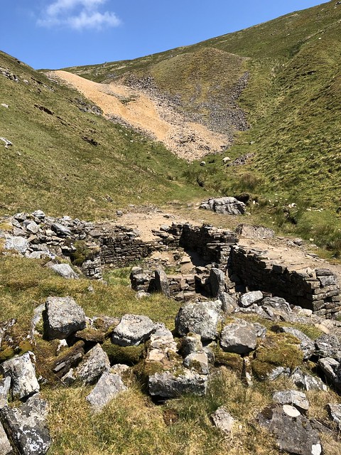
Up ahead the vee of the valley was blocked by a great orange-yellow heap of spoil from the Buckden Lead Mine that once roared and hammered up in this remote spot. We passed broken buildings and rubble-strewn ground scattered with the tiny white flowers of spring sandwort, a metallophyte or plant capable of flourishing on ground polluted with heavy metals – a delicate entity to grace an industrial wasteland, albeit framed by green hills.
Up at the 702m summit of Buckden Pike we sat to catch our breath and take in the view – north over an immense lowland, south towards the Peak District, and west to where the Three Peaks of Yorkshire stood clear in their characteristic shapes – Whernside’s rising ridge, Ingleborough’s tall double hump, and the sloping leonine profile of Penyghent.
The long descent across the moor and through a network of stone walls was glorified by the sunlit westerly prospect up Langstrothdale, the dale sides undulating downward in a smooth succession of limestone ribs and sloping green pasture, an encapsulation of all that makes the Yorkshire Dales such wonderful walking country.
How hard is it? 5 miles; strenuous. NB A walk for agile, sure-footed walkers, properly shod. Narrow path with unguarded drops; some rock scrambling along Buckden Beck.
Start: National Park car park, Buckden BD23 5JA (OS ref SD 943773)
Getting there: Bus 72B (Grassington-Buckden), 874 (Leeds, Ilkley) Sun, BH
Road: Buckden is on B6160 between Cray and Kettlewell (signed from A684 Leyburn-Aysgarth)
Walk (OS Explorer OL30): Leave car park through gate (‘Cray Hill Bridge, Buckden Pike’). Right (‘Buckden Lead Mines’) along wall, then left on path on left bank of Buckden Beck. Path soon becomes narrow and twisting. Just before first tall waterfall, path hairpins back to left (947776 approx), then short scramble up rock outcrop. Same again just before second tall fall (948776 approx). Above second fall, cross fence before changing to path on right bank. In ½ mile at mine site (954781), up left side of spoil heap, on into ruins. Just before arched entrance, left on path (wall on left). In 100m right uphill beside wall on left. Follow this clear path uphill for 800m to angle of wall (961786). Left (ladder stile) to trig pillar on Buckden Pike (961788). Ahead by wall; then follow clear path, slippery and rocky in places, for 2¼ miles back to Buckden.
Lunch/Accommodation: Buck Inn, Buckden BD23 5JA (01756-761933, thebuckinn.com)
Info: National Park Visitor Centre, Grassington (01756-751690, yorkshiredales.org.uk)