Search Results : Bristol

Jan 222011
 

A brisk, blowy, blustering day on the North Devon coast, with a scudding grey sky and big Atlantic waves racing onshore to smash against the wicked black rock teeth of the cliffs. I actually felt the ground quake beneath me as I pushed north into the wind along the line between sea and land, wondering whether leaving the warmth and light of the Hartland Quay Hotel had been a good idea after all.
First published in: The Times Click here to view a map for this walk in a new window
picture picture picture picture picture picture picture
Facebook Link:
Tides are strong and cross-currents treacherous out at Hartland Point, where the Devon coast cuts at right angles from north to east on its outer entrance to the Bristol Channel. Curved and contorted bands of sandstone, ground by the sea into upturned razor edges, lie just below the surface – they have brought thousands of sailing ships to grief down the years. I paused by the lighthouse on the point and took a last breathless prospect of dark sky, dark sea and black rock before heading inland along the high-hedged lanes so characteristic of this part of the world.

In the shelter of the lanes the wind, roaring high overhead, scarcely trembled a leaf. The loom of the ground shut away the hiss and crash of sea against rocks. I threaded the deep holloways past farms with Betjemanic names – Blagdon and Blegberry, Berry and Wargery – with the sounds of trickling water and tentative robin song for company.

In the ridge-top village of Stoke, master craftsmen down the centuries have beautified St Nectan’s Church. I admired the Tudor panelling of the rood screen, all slender ribs and exquisite floral detail, and the roof with its coruscating stars and carved bosses. Then it was out and on along the field lanes, dropping down to the cliffs and the roar of the wind once more.

The great waterfall at Speke’s Mill Mouth was a lace veil blown to rags, the floor of the cove a seethe of white foam among black rock scars. Above the green shark’s tooth of St Catherine’s Tor a raven was struggling unavailingly to fly north, kept at a standstill in mid-air by the counterblast of the wind. I put my head down and shoved on, a midget in motion among the huge forces of nature. Later, sitting in the warm bar of the Hartland Quay Hotel, I found my cup of tea tasted salty – legacy of all the sea wind and spray absorbed by my beard on this wild and entrancing walk.

Getting there: M5 to Jct 27; A361 to Bideford; A39 towards Bude. ¼ mile beyond B3237 Clovelly turning, bear right on minor road to Hartland and Hartland Quay.

Walk (7½ miles, moderate/hard grade, OS Explorer 126): South West Coast Path/SWCP (fingerposts, acorn symbols) north to Hartland Point. Just before radar station, inland. In 100 m, ahead (‘bridleway, Blegberry’) past Blagdon Farm; bridleway for 3/4 mile to road. Right to Blegberry Farm. Left (‘unmetalled road’); green lane for ½ mile to road. Ahead past Berry Farm, across Abbey River; road up to Stoke. Left; immediately right up lane by Rose Cottage. In 200 yards pass ‘Unsuitable for Motors’; keep ahead for a good half-mile. At Wargery, right to road at Kernstone Cross; right (‘Kernstone’) for 450 m to T-junction; left through gate (‘Speke’s Mill Mouth’) on grass path; SWCP north to Hartland Quay Hotel.

NB – Online maps, more walks: www.christophersomerville.co.uk

Conditions
Beware strong wind gusts on exposed cliff tops! Many steps, many climbs and descents. Allow 3-4 hours.

Lunch: Hartland Quay Hotel (01237-441218;
www.hartlandquayhotel.co.uk) – friendly, characterful and welcoming.

More info Bideford TIC (01237-477676);
http://www.visitdevon.co.uk/site/areas-to-visit/north-devon-and-exmoor;
www.ramblers.org.uk;
www.satmap.com

 Posted by at 12:08
Jan 082011
 

'I made out, approaching across the sands, a slow black dot (which) resolved itself into a Ford car. This indomitable thing, rust red, its mudguards tied with string, splashed and slithered towards me; and at the wheel was a handsome young girl with blue eyes and a soft Scots voice … So we splashed over the sands to Lindisfarne.'
First published in: The Times Click here to view a map for this walk in a new window
picture picture picture picture picture picture picture
Facebook Link:
Alas, the famous salt-rusted taxis of Holy Island that so entranced the ultra-romantic H.V. Morton in 1927 are long rotted to pieces. But romantics of all kinds and conditions can do as I did this blowy day on the Northumberland coast – hoist their footgear and follow the ancient pilgrim path barefoot over the wide tidal sands. Tall rough poles mark the straight way, and there are barnacle-encrusted wooden refuge towers for foolish virgins to clamber into if beset by a rising tide.

The ribbed sands felt cold to the sole. Bladder wrack crunched underfoot. It was a good long hour’s walk. The green sandhills and huddled village of the island seemed to draw no closer until the last moment. But this was a heavenly way to cross to Holy Island, or Lindisfarne, to give it an older and lovelier name.

Holy Island village is still partly a fishing community, mostly for crab and lobster these days. Creels lean drying against house walls in the narrow lanes. People come to Lindisfarne for its peace, its small-scale beauty and for its remarkable monastic history. St Aidan of Iona established Lindisfarne’s monastery in the 7th century. St Cuthbert became its hermit Bishop and saintly icon. The ‘most beautiful book in the world’, the illuminated Lindisfarne Gospels, was crafted here. The little island off the Northumbrian coast kept alive the flickering light of Christianity during the Dark Ages; and when Holy Island was reoccupied after the Norman Conquest (the monks having fled Danish raids in 875AD) a wonderful new monastery was built here.

Lindisfarne is full of marvels. Wind and weather have sculpted swirling shapes in the red sandstone walls of the church, whose ‘sky arch’ springs 50 feet in the air, seemingly unsupported. Down by the harbour old herring boats, sawn in half and upturned, make fishermen’s huts. Lindisfarne Castle rides the basalt knoll of Beblowe Crag like a tall ship; Sir Edwin Lutyens redesigned it for drama, and Gertrude Jekyll laid out the walled garden ablaze with colour.

Inland, the humps of the Cheviot Hills began to fade under rain. The island’s strollers vanished into the tea shops, and I was left alone to walk the north shore dunes, savouring wind and showers, the barking of pale-bellied brent geese newly arrived from Svalbard, and the eerie singing of seals on the sands.

Start & finish: Holy Island causeway car park, Northumberland (OS ref NU079427)

Getting there:

Fly Easyjet (www.easyjet.com) to Newcastle from London Stansted, Bristol, Belfast City. Train (www.thetrainline.com; www.railcard.co.uk) to Berwick-upon-Tweed (10 miles). Bus service 477 (www.perrymansbuses.co.uk) from Berwick. Road: Holy Island is signed off A1 between Belford and Haggerstone.

Website version

Walk: (10 miles including sands crossing, 3½ miles island circular; easy; OS Explorer 340): From car park follow causeway, then pilgrim route posts, to Chare Ends on Holy Island (NB see below!). Follow road to Priory ruins (12648 – signposted). Return to Market Square; between Crown & Anchor and Manor House Hotel, follow path to shore. Left round harbour; on to castle (detour to Gertrude Jekyll’s garden – 136419). Continue on coast path, past The Lough and National Nature Reserve notice. Follow path to left along line of dunes for ½ mile to meet fence at NNR notice (129433). For island circular, left through gate, ahead to village. For sands crossing, keep ahead for ½ mile; bear left (122433) with causeway on right, to rejoin posts at Chare End.

NB: Causeway is impassable 2½ hours either side of high tide. Tide times posted both ends of causeway; or visit www.lindisfarne.org.uk.

Lunch: Plenty of options in village

Holy Island Accommodation: Manor House Hotel (01289-389207; www.manorhouselindisfarne.com); Crown & Anchor (01289-389215; www.holyislandcrown.co.uk); Ship Inn (01289-389311; www.theshipinn-holyisland.co.uk)

More info: Berwick-upon-Tweed TIC (01289-330733); www.lindisfarne.org.uk; www.visitnorthumberland.com; www.ramblers.co.uk; www.satmap.com.

 Posted by at 00:00
Mar 132010
 

First published in: The Times Click here to view a map for this walk in a new window
picture picture picture picture picture picture picture
Facebook Link:
There’s definitely something strange about the river country along the Severn Estuary. Whether it’s the influence of the mile-wide tideway, the big overarching skies, or the highly idiosyncratic dwellings and their occupants down the twisty lanes that end abruptly at the river, to walk here is to step away from the everyday into some parallel, Severn-centred universe.

Setting out from Brookend, a few miles north of Bristol on the ‘English bank’, Jane and I found ourselves straight away in a tangle of wide old green lanes. You feel that the landscape must be flat, so close to such a big river, so it comes as a shock to top a rise of ground and find a 20-mile view unrolling. To the east the long South Cotswold ridge, May Hill and the heavy tree cover of the Forest of Dean swelling in the west, and between them the Severn hurrying seaward in a muscular double bend of low-tide tan and silver – we halted to gaze our fill before hurrying down the slope into Purton.

In the early 19th century a 16-mile-long canal was dug from Gloucester down to Sharpness on the lower Severn, cutting out some of the dangerous river bends. Purton, right beside the canal, became a busy little place. Nowadays it’s a sleepy waterside hamlet once more, full of charm and possessed of a true classic of a never-changing pub. No food, no late opening and no nonsense at the Berkeley Arms under the admirable guidance of Mrs Wendy Lord – just a huge fire, stone floors, comfortable old settles, and beer so good it sits up and begs to be drunk. Resistance is useless.

Just down the river path we found an extraordinary elephant’s graveyard of redundant boats – dozens of concrete barges and wooden Severn colliers, rammed into the mud during the late years of the 20th century to stabilise the tide-burrowed bank between river and canal. Lovingly labelled by the ‘Friends of Purton’, they cluster the margins of Severn in death as in life – Orby, Abbey, Huntley and Harriett, their timbers shivered, their sides split, tillers and hawseholes still bravely held aloft, a poignant gathering.

On down the canal, and through the abutments of a mighty railway bridge that once spanned the Severn. On the night of 25 October 1960, in a thick autumn fog and pitch darkness, two tankers – one loaded with oil, the other with petrol – collided with the bridge piers and exploded, sheeting the river in flame and killing five of the eight crewmen. The damaged bridge was eventually demolished, but the remnants of the tankers are still seen on the riverbed at low tide, and plenty of people around the river port of Sharpness retain vivid memories of that awful night.

Sharpness itself is a rare survival, a working port handling cement, fertilizer and scrap metal far up the tidal Severn. We stopped to watch the cranes swinging bags of fertiliser out of the hold of Shetland Trader, then crossed the canal and made for the field path to Brookend with a sharp appetite apiece. ‘Try the antelope and ginger sauce,’ suggested cheery Dan in the Lammastide Inn. I thought he was pulling my leg, till I looked at the menu board. You’re not in Kansas any more, Toto.

Start & finish: Lammastide PH, Brookend, Sharpness GL13 9SF (OS ref SO 684021)

Getting there: Train (www.thetrainline.com; www.railcard.co.uk) to Cam & Dursley (7 miles); several buses to Sharpness (www.carlberry.co.uk). Road: M5 (Jct 14); A38 (‘Gloucester’); B4066 (‘Sharpness’); right to Brookend. Park at Lammastide PH (please ask permission, and give the pub your custom!)

Walk (6½ miles, easy, OS Explorer OL14): From pub, right past phone box; left on bend (‘bridleway’). In 100 yards at gate, keep left on green lane. At T-jct, right (686023 – blue arrow). In 300 yards, opposite gate, left (689022 – ‘footpath’ stone) across fields (gates, yellow arrows/YAs) for 1 mile to Purton. Reach road left of church. (682042). Ahead across canal; left to next bridge (691044); right past Berkeley Arms PH. Riverside path joins canal towpath (687044). NB To see beached boats, detour right here.

Towpath into Sharpness; cross canal (670030). Up steps (‘Severn Way’); ahead past bungalows; right past Dockers’ Club (671029) to road. Left across the taller swing bridge that’s nearer the canal (673029). Ahead to road (677026); right (‘Sharpness’). Left beside Village Hall (674021 – fingerpost); cross stile; left to cross stile in hedge (678021); up hedge, through gate at top; YAs to Brookend.

NB – Online map, more walks: www.christophersomerville.co.uk

Lunch: Lammastide Inn (friendly and handy): 01453-811337

Drink: Berkeley Arms (open Wed-Sun, 7-10; Sat-Sun 12-2).

More info: Stroud TIC (01453-760960)

www.visitbritain.com/en/destinations/england/south-west/gloucestershire

www.ramblers.org.uk

 Posted by at 00:00
Jul 042009
 

First published in: The Times Click here to view a map for this walk in a new window
picture picture picture picture picture picture picture
Facebook Link:
Frederick Hervey, 4th Earl of Bristol, Bishop of Londonderry from 1768-1803, was a remarkably broad-minded man. In that intolerant era of Penal Laws against Catholics, the Bishop allowed the local priest to celebrate Mass in the Mussenden Temple, one of the follies he erected around his preposterously extravagant Downhill Estate on the cliffs outside Castlerock. Hervey was also fabulously red-blooded and eccentric, fond of his wine and the ladies, addicted to foreign travel and art collecting, apt to have himself borne around in a palanquin and to drop spaghetti on the heads of pilgrims passing below his balcony in Rome.

Jane and I entered Downhill on a brisk windy morning under the knowing grins of the ounces or mythic lynx-like beasts that guard the estate’s so-called ‘Lion Gate’. Beyond lay the Bishop’s enormous Palace of Downhill in poignant ruin, its grand fireplaces hollow and stark, its windows blank, state rooms carpeted with grass and open to the sky. In the heyday of Downhill this incredible centre of luxury high on the cliffs had an entrance facade flanked by Corinthian pilasters, with a double stair leading to the door. There was a State Dining Room, a State Drawing Room, and a two-storey gallery for the Bishop’s superb art collection, all covered by a magnificent dome. Facade and double stair still stand, but now the interior walls, once beautified with exquisite plasterwork, are sealed with functional Ministry-of-Works concrete, the elaborate mosaics are gone from the chimney breasts, and buttercups and clover have taken the place of Wilton and Axminster. It’s a strange, uncanny and altogether haunting atmosphere in the empty shell of the Palace of Downhill.

Down on the brink of the basalt cliffs beside the domed Mussenden Temple, we looked out on a most sensational view: the sea shallows creaming on seven clear miles of sand that ran west in a gentle curve towards the mouth of Lough Foyle, with the clouded hills of ‘dark Inishowen’ beckoning from far-off Donegal.

That proved a quite irresistible call. Down on the strand we pushed into the wind. Waves hissed on the tideline, sand particles scudded by. Surfers rode the waves like water demons. The black and green rampart of the cliffs was cut vertically by white strings of waterfalls, the falling cascades blown to rags in mid-plummet. All this vigour and movement whipped us onwards to where the preserved sand dunes of Umbra rose between strand and cliff foot. A complete change of tempo here, sheltered among the sandhills, down on our hands and knees among pyramidal orchids of blazing crimson, yellow kidney vetch, lady’s bedstraw sacred to the Virgin Mary, and tall spikes of common spotted orchids of such a seductive milky pink and blue it was all I could do not to take a surreptitious lick at them.

Lying prone in the dunes, looking back through a screen of marram grass and clovers, we saw the dark pepperpot shape of the temple on the brink of Downhill cliff. Had the bold Bishop of Londonderry kept a mistress in there, as stories say? I rather hope he had, and his palanquin and spaghetti-tureen, too.

Start & finish: Lion Gate car park, Downhill Estate, Castlerock BT51 4RP (OS of NI ref C 757357)

Getting there (www.nirailways.co.uk): rail to Castlerock (½ mile), Ulsterbus service 134. Road: On A2 between Castlerock and Downhill Strand

Walk (6 miles, easy grade, OS of NI Discoverer 04): From Lion Gate car park explore Walled Garden, then Downhill Palace ruin, then Mussenden Temple (758362). Return anti-clockwise along cliff. From Lion Gate cross A2 (take care!); right downhill beside road on pavement. Short stretch with no pavement leads to foot of hill. Right under railway; left along Downhill Strand. After 1 ¼ miles, where river leaves dunes, look left for Ulster Wildlife Trust’s Umbra Dunes notice (732359). Follow fence through dunes to descend on Benone Strand. Continue to Benone (717362 – lavatories, Visitor Centre, sometimes ice cream vans). Return along beach and A2 to Lion gate car park.

NB – Online map, more walks: www.christophersomerville.co.uk

Lunch: Pretty Crafty Studio (signed across A2 from Lion Gate) for a cuppa and cakes

Accommodation: Downhill Hostel (028-7084-9077; www.downhillhostel.com) at foot of hill – dormitory (from £12) or private (from £35 dble, £60 for 4 adults). Whole hostel bookable.

More info:

Downhill (NT): 028-2073-1582; www.nationaltrust.org.uk

Coleraine TIC: 028-7034-4723; www.discovernorthernireland.com

 Posted by at 00:00
Mar 072009
 

First published in: The Times Click here to view a map for this walk in a new window
picture picture picture picture picture
Facebook Link:

A male blackbird, yellow bill a-tremble, was making tentative inquiries of a drab brown female on a bough in the New Inn's garden as I started down the hill towards Blagdon Lake. The celandines were still curled tight and green along the high-banked lane, but there was a breath of warmth in the low sun, more than Somerset had felt for the past three months.

For well over a century Blagdon Lake water has been piped to Bristol's taps, ten miles over the hills to the north. Crossing the broad dam of the lake, I heard the subdued roar of the flood-engorged weir where snowmelt and swollen streams were sending their waters surging down the spillway. I followed the fishermen's path through the trees along the north bank of the lake, then struck out across fields thick with the winter's mud to reach the lane by Bellevue Farm – well named for its prospect of water and hills.

A little way up the lane I was pulled up short by the sight of a large badger squatting on its haunches in a cottage garden. It shouldn't have been out of its sett this early in the year, and it certainly should have fled at sight of me, instead of fixing me with a sleepy stare. It was I who walked away, leaving the badger master of the place.

The southward views grew better and better as the lane rose, until at the top of Awkward Hill I looked down over fields patchworked with green grass and red ploughland, out across the whole expanse of Blagdon Lake to the steep wall of the Mendip Hills beyond in early afternoon shadow.

The late winter light, already beginning to diminish, lay softly on the lake with a blurred sheen more like watered silk than the hard mirrored effect of a summer day's sunshine.

Down by the lake once more, I squelched towards Blagdon over boggy meadows where wild geese went lumbering into the air at my approach, trumpeting reprovingly. It was almost time for them to be off to their mating and brood-rearing, 2,000 miles north of these green Somerset fields.

Back at the New Inn, sitting on the terrace with a cheddar ploughman's and a kingly view over the lake, I heard the love-struck blackbird – or possibly another like him – still singing for spring.

Start & finish New Inn, Blagdon BS40 7SB (OS ref ST 505589)

Getting there M5 Jct 21; A 371, A368; left in Blagdon opposite Live & Let Live PH to New Inn.

Walk (5 miles, easy grade, OS Explorers 141, 154): from New Inn, walk down Park Lane, along the reservoir dam wall. On the far side, go right (504603) beside reservoir for half a mile, then forward (511608) to Bellevue Farm at West Town (517604). Left for 10 yards to road, right for three quarters of a mile; 300 yards past the top of Awkward Hill (nameplate), right over stile (527600), following path over stiles, down across fields to road (529593). Left for 250 yards; just before industrial chimney, right (531591 – footpath sign) into damp fields. Follow the footpath close to the reservoir for 1 miles; 500 yards past Holt Farm, bear left (510591) on an uphill path back to Blagdon.

Lunch New Inn (01761-462475), superb lake views from garden; NB no children indoors.

More info Wells TIC (01749-672552); www.visitsomerset.co.uk


 Posted by at 00:00
Mar 012009
 

Introduction

I have been inspired by writers, painters, musicians, poets; by naturalists, birdwatchers and wildflower experts; by conservationists and their vitally important work. And I have been galvanised by the wildly changing weather of these islands, the beautiful and absorbing manifestations of our four distinct seasons, the splendour and variety of our landscapes, and the company of countless workers, idlers and walkers I have met along the way and what they’ve had to say about a thousand things.

Christopher Somerville’s 100 Best Walks is designed to grab you by the ear and tug you outdoors. Meanwhile, here is a personal Six of the Best …


Aldbury and Ashridge, Chiltern Hills, Herts/Bucks (July 1998)

Up in the beechwoods on the Ashridge slopes above Aldbury, a softly fluting thrush was chief herald of a dawn that had hardly broken yet. I had yawned my way out of bed at two o'clock this morning to enjoy the moment so often read about, so seldom experienced, when the first birds crack the silence of night before traffic roar intrudes to spoil things. To have the whole of the Chiltern ridge entirely to myself, to be able to walk the chalk tracks through the trees without seeing another soul, was a pleasure so intoxicating that I found myself striding along through the half light more like a race walker than a man with time to dawdle and linger.

I turned off the path and sat down on a fallen tree to luxuriate in this unaccustomed sense of time in hand. Light was beginning to touch the beech trunks and leaves, and there was a pearly pink look to the sky in the east. Drifts of mist curled between the trees, and the air in the woods was cold enough to nip my fingers white.

In the treetops the dawn chorus was in full swing. Blackbirds, thrushes, chaffinches; a chiff-chaff repeating its name over and over again; a blackcap bubble-and-squeaking; wrens reeling out chattering streams of notes. From overhead came the chak-chak of rooks passing, and under everything lay a soft foundation of wood pigeons’ throaty cooing. A glorious row, that had me spellbound for half an hour as the daylight slowly broadened.

Barnsley and Bibury, Gloucestershire (January 2001)

The old ridge track, probably a prehistoric route in its origins, lay puddled and rutted. I followed it for a mile or so, head down, buffeted sideways by gusts that leaped with a shriek out of a dramatically darkening sky. Time to get off the ridge, down to more sheltered ground. I made it into St Mary's Church at Bibury just as the storm broke in earnest.

St Mary's is a good place to sit out a rainstorm. There is Saxon, Norman and Early English work to admire, and a fine display of beautifully carved stone foliage. I idled dreamily in a pew until the rain ceased crashing on the windows.

Bibury gleamed as I walked its higgledy-piggledy courts and streets. The Cotswold stone houses shone in a glaze of sunlit rainwater. The River Coln sluiced viciously under the arches of the little stone footbridge that led to the crooked 17th-century weavers' cottages of Arlington Row. The green acres of Rack Isle, where the weavers once hung their wool to dry, lay drowned under four feet of water. 'No-one in the village has ever seen it like this,' said the man laying sandbags on his doorstep. 'Just have to hope for a change in the weather, won't we?'

As I climbed the trickling track of Hay Lane, the western sky was all a purple bruise. One chink of lemon yellow sun broke through, running an electric wire of gold along the upper rim of the cloud bank – a sight I would have braved a dozen rainstorms to witness.

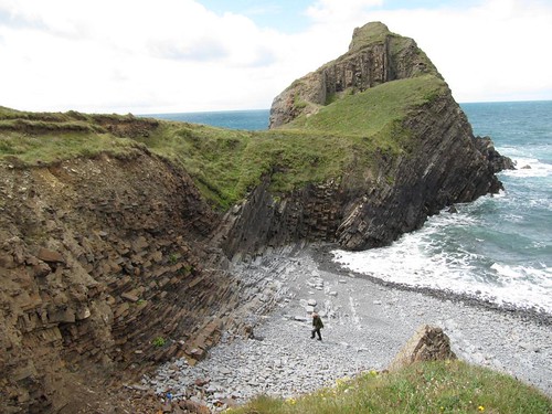
Worm’s Head, Gower, South Wales (June 2000)

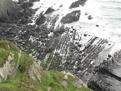
Taking the two-mile scramble to the tip of dragon-shaped Worm’s Head is not as easy as it looks. You have to read your tides right. Currents are fierce here in the widening throat of the Bristol Channel, and many a careless venturer down the centuries has been swept away to death as the rising tides come swirling together.

The rocks of the causeway lay coated with millions of mussel shells that were themselves encrusted with a camel-brown layer of barnacles. In the rock pools blennies flicked from sunlight into the shelter of weed and anemone fringes, and hermit crabs went tip-toeing hastily from one dark crevice to the next as my shadow barred the water round them.

As the falling tide seethed back from the northern and southern edges of the causeway, the pattern of the rocks of Worm’s Head became clear. Hundreds of close-packed parallel lines of strata lay upended in the floor of the sea, ground down flat on the margins of the shore, rising to show through the meagre turf of the Inner Head’s nape like cranium skin peeking between the lines of a comb dragged through thinning hair.

I crunched on over carpets of broken mussel shells, passing a big rusted ship’s anchor lying tines up, and clambered up from the causeway on to the slope of the Inner Head. A strange name, since this 150ft lozenge of grass-grown rock is so obviously the body of the twin-humped promontory that Norse sea-rovers named Wurm or ‘dragon’. I checked my watch as I came ashore. Better be back here in a couple of hour’s time …

Hathersage and Stanage Edge, Peak District, Derbyshire (February 2008)

Stanage Edge, the rocky rim of what was once a gigantic dome of millstone grit, is climbers’ and boulderers’ heaven. The grey adhesive rock, fractured into steps, cracks and layers, offers challenges to test the virgin tyro as well as the complete and utter expert. Famous names from that introverted, macho and phenomenally athletic world, the hardest of the ‘hard man’ school – Don Whillans, Nat Allen, Joe Brown and their ilk – cut their climbing teeth along these modest-looking crags. They and their successors dubbed every climbable crack and interstice with names superbly curt and clipped: Goliath’s Groove, Agony Crack, The Unconquerables, The Vice, Blockhead Direct, Queersville, The Eliminator.

I strode the flat, tricky gritstone pavement along the Edge, face to the cold wind, in a kind of high-level ecstasy. Climbers crouched and sprawled in impossibly heroic poses on every crag, and beyond them a most enormous view opened to the south and west across the frosted fields and shadowy moors and edges of the Dark Peak. To the left ran cream and purple moors, the wind streaming their pale grasses so that the whole wide upland appeared to be in motion, racing north into Yorkshire.

Higger Tor and Carl Wark lay ahead, flat-topped tors like castles. I stormed their walls in an outpouring of supercharged energy. Then, breathless and buffeted, I dropped down through tumbled meadows around Mitchell Field Farm and the mock-baronial miniature fortress of Scraperlow House; down towards Hathersage, the warmth and light of the Scotsman’s Pack inn, and the grey church spire that marks where Little John lies sleeping until Robin’s horn wakes him for one last chase through the glades of the eternal Forest.

Poetry Path, Kirkby Stephen, Cumbria (September 2005)

It was a filthy, gale-torn day, with the rain-swollen River Eden crashing majestically through the woods and milky curtains of wind-rippled rain parting and closing on the Cumbrian fells. But Meg Peacocke was happy to brave the elements with me. It was Meg who created the twelve poems that were carved by sculptor Pip Hall into stones along the Poetry Path.

‘I found it very interesting and challenging,’ Meg told me as we walked the muddy river bank on a carpet of leaves whipped from the trees by the gale. ‘I wanted the poems to communicate themselves to anyone, non-poets really, and in particular these local farmers and farming people whom they celebrate.’

The poems are subtly located – January in an angle of bank by the Swingy Bridge, February on a pile of blocks opposite a lovely old stone barn, March in a pool below a natural spillway of tiny waterfalls. The carved cameos include April lambs butting milk from their mother’s udder, July haymakers hefting a bale, brawny farmers inspecting sheep at an October sale.

In Kirkby Stephen this afternoon the local farmers would still be hanging over the pen gates at the mart, or driving the Swaledales they’d chosen in the auction ring back up to the fellside farms. Down here in the valley I ran my hand over Pip Hall’s sculpture of sheep in a pen, and savoured Meg Peacocke’s words:

‘Penned in a huddle, the great tups

are clints of panting stone. The shepherd lifts

a sideways glance from the labour

of dagging tails. His hands are seamed with muck

and the sweat runs into his eyes.

Above us, a silent plane has needled

the clear blue. Paling behind it

a crimped double strand of wool unravels.’

Glen Esk, Angus, Scotland (May 2005)

The world of science lost a great botanist when music sank its fatal talons into Dave Richardson. I would have seen nothing on the ascent from Glen Esk if it hadn’t been for my sharp-eyed friend. ‘Broad buckler fern under the rock here,’ mused Dave, his restless curiosity all fired up, ‘and, let me see … yes, green spleenwort. Yellow mountain saxifrage, not really open yet of course – and purple saxifrage … hmm, cloudberry, Rubus chamaemorus, yes …’ The bare rocks seemed to flower as he pointed out their spring glories.

Up in the broad glen of upper Glen Unich we picnicked, dangling our legs from the footbridge upstream of the Falls of Damff. Tracks, rocks and open patches of moorland glittered with mica in the weak sunshine of early spring. Away to the north the three thousand foot crest of Mount Keen rose above all its sister peaks. Scuds of cloud swept up and across the steady blue field of the sky. This was spring in Angus as I had imagined it while coming north through grey weather from a stale southern city – cold, clean and entirely captivating.

We licked the last of the Arbroath smokie pâté from our fingers, swigged the remnants of the tea, and made off along the Water of Unich among stubbly peat hags and the black channels of hill burns. Mountain hares in snow-white coats went bouncing away over the dark heather as we descended to Inchgrundle farmhouse. A scimitar-winged shape skimmed close over the waters of Loch Lee – the first swallow of spring. I made up my mind that tonight I would get out the melodeon and persuade Dave to help me nail for good and all that tricky turn in ‘Out On The Ocean’.

 Posted by at 00:00
Mar 312007
 

Driving north across the plains of Extremadura I ran into an army of dust devils. Whipped up by the cold winds of spring, they rushed bowing and whirling across the flat landscape. In the vast fields the tiny figures of Extremaduran farmers, digging and hoeing in timeless labour, hardly bothered to look up as the spirals of dust and last year’s holm oak leaves sped by them.


Groves of crusty-barked cork trees, orchards foaming with pink and white blossom, rows of stumpy vines pruned hard back to the dark earth, brimming ditches lined with thrashing reed beds and whistling willows – these signs of a fruitful land were suddenly extinguished by a slate-grey curtain of rain marching in from the low dark sierras on the western horizon. All was blotted out. Five minutes later Extremadura re-emerged, arched over by a superb double rainbow in front of which flew a leisurely line of cranes, their ragged wings taking them north to their boggy breeding grounds thousands of miles from Spain. Rain, cranes, sharp winds and labouring farmers – all was exactly as my friend Frank Caňada, born-and-bred Extremaduran exiled to Britain, had described when he urged me to spend a few days of early spring in his native village of Navalvillar de Pela.


Spring and autumn bring the rains that turn the soil rich and the grass green, and they also see birds by the million on migration. Yet the regional name of Extremadura (‘extremely tough’) has been hard earned. This is a place that bakes in 40o of heat in summer and freezes in sub-zero temperatures when winter strikes. And tough describes its people, often forced by poverty to emigrate, fiercely proud of their traditions, conservative to the backbone.


Ten minutes after knocking at the door of Frank’s parents, Antonio and Petra Caňada, I was sitting at their dining table, eating Petra’s home-killed pork and drinking tiny tumblers of Antonio’s home-made wine, with my rain-chilled feet perched to warm on the rim of a giant bowl of glowing embers. This was central heating, Navalvillar de Pela style, and I couldn’t get enough of it.


Conversation spat and sparked as my Spanish phrase book took a battering. Antonio smiled ferociously at me from under his brows, an expression I well remembered from my previous visit to Navalvillar. That had been on a frosty January night, on the occasion of the village’s horse-centred Festival of San Anton. A confirmed and cowardly non-rider, I had found myself galloping recklessly between bonfires through the town’s narrow streets, under a starry sky. It was Antonio who had grasped me by collar and waistband and thrown me bodily up onto the horse before I could demur. Now, recalling my terror on that distant night, he smacked his legs and roared with laughter.


I lodged in the Casa Rural La Lozana in a back lane of Navalvillar – one of those splendid Spanish rural guesthouses that for neatness, stylishness and sense of welcome put most British B&Bs to shame – and spent every waking hour with the Caňada family. One day we picnicked by a lake in the Sierra de Pela, and I climbed with Antonio to a peak jewelled with violets and daisies. On Sunday, a beautiful cold day of blue sky, we went to church among flocks of black-clad crones, and I recognised the priest as the one who had stood with holy water on the Feast of San Anton to bless the cattle, horses, dogs, hamsters, cats and goldfish brought to the church by members of his congregation.


One day I spent on my own, venturing north through another rainstorm to the Monastery of Santa Maria at Guadalupe. This is arguably Spain’s most famous place of veneration. The huge walled monastery contains glittering treasure – paintings by El Greco and Goya, embroidered altar cloths, jewelled crosses; also an ivory Crucifixion, said to have been carved by Michelangelo, whose miniature Christ I saw kissed with great reverence by a young, black-clad woman. The monastery is also the setting for a tiny statue of our Lady of Guadalupe, so reverenced in medieval Spain that the Virgin of Guadalupe became patron saint of all Spain’s territories in the Americas. Dwarfed by angels, saints and pinnacles in her fabulously elaborate altarpiece, the Virgin stares serenely over the heads of tourists, guides and worshippers alike.


On a cold, cloudless morning I left Navalvillar and drove north. Fertile fields gave way to the harsher rock of the Sierra Brava. Snow capped the peaks, and the stone walls of the city of Trujillo shone pale on their high saddle of ground. Here I met up with Martin Kelsey, an expatriate Englishman who runs the Birding Extremadura company. Martin, I’d heard, might be able to get me within sight of that giant elusive bird of the open grasslands, the great bustard. Ever since learning in childhood of the extinction of Britain’s great bustards – hunted to non-existence on Salisbury Plain by 1832 – I had longed to catch sight of the big turkey-like birds with their handsome chestnut breasts and flashing white wings. The wide grassy plains of Extremadura, where male great bustards meet in spring to ‘lek’ (join in communal display) and mate with the rather drab females of their species, seemed my best bet, especially under the expert tutelage of a guide as experienced and passionate as Martin.


First, though, we took a swing through the city of Trujillo. It is just the right size to walk around in half a day, an evocative jumble of medieval houses and tight, steep lanes centred round a square where Francesco Pizarro stands a-triumph in statue form. The ruthless conquistador, who with his 180 men suppressed the Inca nation in the 1530s, inspired others to grow rich on the blood of South American peoples. Trujillo owed its prosperity to Pizarro and his followers. Nowadays he poses in the town square, sword on hip, staring from beneath his coal-scuttle helmet at the snogging teenagers and hurrying housewives of Trujillo.


My day with Martin yielded ornithological wonders – hen harriers flapping over the pastures, a colony of storks in a clump of dead trees, golden-plumaged griffon vultures and a rare black stork in cliffs above the River Tagus. It was nearer Trujillo, out in the broad green expanses of the Belen plain, that we went looking for my dream birds.


‘These are steppes,’ Martin pointed out as we drove down a bumpy road, ‘grasslands that have never been irrigated or intensively managed. They’re full of flowers and insects, and therefore of birds. Great Bustards do very well here – I reckon there might be five or six thousand in Extremadura.’


A stunning view opened out towards the snowy mountains. On a grass ridge not far away, chestnut-coloured dots were moving. Five magnificent male great bustards paced the ridge with long, powerful strides. Their white underparts, glossy brown necks and fox-red backs showed up dramatically against the sunlit green of the grass. We watched through Martin’s telescope as two of the birds bowed to each other, fluffing up their chest plumage and flicking their wings upside down to display the brilliance of the white under-feathers.


‘They’re practising lekking,’ said Martin. ‘In a few weeks’ time the females will be here, and these boys will have their work cut out to make their mark.’


Spring seemed stirring all over the steppes and sierras of Extremadura. Breaking free of its winter chains, the hard land felt full of vigour, full of life. I stood holding my breath, watching the great bustards flick from white to chestnut and back to white, and marvelled at my luck.


TRAVEL: FACT FILE


Getting there: Easyjet (www.easyjet.com) fly to Madrid from London Gatwick, Luton, Bristol and Liverpool; Ryanair (www.ryanair.com) from East Midlands to Madrid and Granada, and London Stansted and Liverpool to Seville; Iberia (www.iberia.com) from Madrid to Badajoz   


STAYING: Navalvillar de Pela – Casa Rural La Lozana, Calle Moreno Nogales 18, 06760 Navalvillar de Pela (Badajoz). Tel 00-34-924-824-291/924-860-428; www.lalozana.com. Dble B&B from around £42.


Trujillo – Casa Rural El Recuerdo (Martin and Claudia Kelsey), Pago de San Clemente, Apartado de Correos 28, 10200 Trujillo (Càceres). Tel 00-34-927-319-349; mobile 609-684-719/609-684-631; www.birdingextremadura.com. Dble B&B from £45; evening meal inc. wine £12.


BIRDING EXTREMADURA: www.birdingextremadura.com. Guided tour including packed lunch: £75 (1 person), £85 (2), £90 (3).


INFORMATION: www.spain.info

 Posted by at 00:00