Search Results : Snowdonia

Nov 252023


First published in: The Times Click here to view a map for this walk in a new window
Llyn Cynwch Cadair Idris from the Precipice Walk Foel Offrwm Iron Age fort wall at summit of Foel Offrwm resting bench looking west towards Afon Mawddach, on path to Foel Offrwm summit Precipice Walk, with Afon Mawddach below 1 Cadair Idris from the Precipice Walk 2 Llyn Cynwch 2 Precipice Walk, with Afon Mawddach below 2

The thrush seemed completely unafraid. It stood its ground under the silver birches on the forest path, its beak full of grubs, as I approached. It wasn’t until we were almost in touching distance of one another that it flew off among the trees. I watched it go, then moved on to where the steely flat waters of Llyn Cynwch made a dull mirror of the upland valley.

This portion of woodland, fellside and upland grazing a few miles north of Dolgellau belongs to the Nannau Estate. Since Victorian times the public has enjoyed the estate’s permission to wander a network of paths. I was setting out on this brisk day to explore the Precipice Walk high above the steep, glacier-scoured valley where the Afon Mawddach widens towards what George Borrow in his classic 1862 travel book Wild Wales termed its ‘disemboguement’ in Barmouth Bay.

A rocky path, clear on the ground but tricky to find footing on, led round the northern nose of a tall ridge before edging back along the brink of the precipice. The slope down to the river 700 feet below was steep and tree-hung, vertiginous in a couple of spots. But the views were quite sensational, out to the estuary below its headland, south to where Cadair Idris sprawled in full majesty of ridges, cliffs, corries and peaks against the clouds.

The Precipice Walk rounded the southern end of the ridge and fell away to the lake shore and a level stroll back to the car park. But I wasn’t quite satisfied. On the other side of the road rose Foel Offrwm, the ‘Hill of Sacrifice’, a tall knobbly eminence crowned with an Iron Age hill fort. The views from up there ought to be sensational too.

And so they were, once I had slogged up the zigzag path, past a tempting resting bench and on up to the tumble of stones that once formed a strong defensive wall for the ancient stronghold at the summit. By the curious square cairn I revolved slowly, taking in one of Snowdonia’s finest prospects – the lumpy Rhinogs and the serpentine Mawddach to the west, the Arans and Arennig to the east where I had climbed last year, the long tented back of Cadair Idris capturing the whole of the southern skyline, and away to the north a hint of the tall mountains that form the roof of Snowdonia.

How hard is it? 5½ miles in total. (Precipice Walk 3½ miles; Foel Offrwm 2 miles up-and-down). Precipice Walk mostly level, but rocky, stumbly path; Foel Offrwm a strenuous hill climb.

Start: Precipice Walk car park, near Dolgellau, LL40 2NG (OS ref SH 745211)

Getting there: Bus 33 (Dolgellau – Llanfachreth)
Road – On Llanfachreth road, signed off A494 between Dolgellau and Rhydymain.

Walk (OS Explorer OL23): Turn right along marked path at top of car park. In ½ mile through gate marked ‘Danger; Deep Drops’ (741212); in 100m uphill along wall. Follow it to right, then follow the obvious ‘Precipice Walk’ circuit. Watch your feet on this rocky path!
Back at car park, cross road and follow lower track parallel with road. In 250m, before gate, fork right (748212, ‘Foel Offrwm’ on marker stone) up side path, through gate and on. In 250m fork right up path (‘Copa Foel Offrwm’). In 100m bend right with the path, and keep climbing in same direction. At bench, fork back left (750213 approx) on path to summit cairn (750209). Return same way.

Lunch: Picnic

Accommodation: Afon Rhaiadr Country House, Rhaiadr Wnion, Dolgellau LL40 2AH (01341-450777, afonrhaiadr.co.uk) – very comfortable and welcoming B&B.

Info: snowdonia.gov.wales/walk/precipicewalk
visitwales.com

Walking the Bones of Britain – a 3 Billion Year Journey by Christopher Somerville is published by Doubleday.

 Posted by at 01:14
Oct 112014


First published in: The Times Click here to view a map for this walk in a new window
picture picture picture picture picture picture picture picture picture picture picture picture picture
Facebook Link:
Capel Curig on a cloudless morning, the sky upturned like a blue porcelain bowl above Snowdonia, the air as fresh as spring water, full of light and clarity. In the west Snowdon thrust up its crown of peaks round a shadowy hollow. Moel Siabod rose like a rocket to the south. What a morning for exploring the rugged uplands that lie north of Capel Curig, the walkers’ and climbers’ mecca in the mountains.

We crossed the stile by the chapel and were away up the fields with tumbled rocks and hillocks rising all round. A well-trodden path led through a mossy oakwood and out into a patch of sun-warmed bog myrtle. We picked a handful of the olive-shaped leaves and sniffed their sweetly spicy fragrance as we climbed on round a great bog in a rocky hollow, northwards towards the pass under the peak of Crimpiau.

‘Go on a bit down the other side, there’s a great view,’ the man in Capel Curig’s Moel Siabod café had urged us. We did so, and were rewarded with a wonderful prospect north-east over the blue waters of Llyn Crafnant framed in a cleft of hills. Back up to the pass, and a meandering climb up to the pale quartz rocks of Crimpiau’s summit. Snowdon stood up dramatically in the west, with Tryfan’s stegosaurus back arched to the sky alongside.

Mountains and uplands were all lit as though by a stage designer granting the dearest wish of every walker out in the hills today. ‘Tryfan,’ said a cheery man as we sat drinking it all in like thirsty travellers in a bar. ‘Up there yesterday, and couldn’t see a thing. Wayfinding was… interesting.’ He smiled. ‘Back to Bedfordshire tomorrow – worst place in the world if you love hills!’

A very rugged and rough path led south off the ridge and down past Llyn y Coryn gleaming in its dark peaty bed like a splash of mercury. A pair of mating dragonflies flew away, banking like biplanes. We descended through heather and gorse, with Snowdon and its cohorts beyond the double lakes of Mymbyr a feast for eyes and soul the whole way down.

Start: Car park behind Pinnacle Stores, Capel Curig, LL24 0EN (OS ref SH 721582)

Getting there: Bus – Snowdon Sherpa S2 (Llanberis to Bettws-y-Coed), S6 (Bangor to Bettws-y-Coed)
Road – Pinnacle Stores is at crossroads of A5 (Bettws-y-Coed to Bangor) and A4086 (Llanberis).

Walk (4½ and a half miles, strenuous, OS Explorer OL17. NB: online maps, more walks at christophersomerville.co.uk): Cross A5; stile beside chapel (‘Crafnant’ fingerpost). In 200m, between trees, ahead on stony path. Gate/stile into wood (725582); out of trees to gate/stile (729581); on to cross wooden footbridge (732581). Left (‘walking man’ waymark); on (stiles) for 1¼ miles, up to pass beside large boulder (738596). On downhill for 200m to Llyn Crafnant viewpoint (738598). Back to pass and boulder; right up path to Crimpiau summit (733596). Path descends south along ridge, aiming for figure-of-eight lakes (Llynnau Mymbyr). Llyn y Coryn soon in sight; keep left of lake (731591) to fence on saddle beyond (731590). Keeping fence on right, down to cross stile (730587). Steeply down to cross stile by stone wall in hollow (729586). Turn right between fence and stone wall; follow fence to cross 2 more stiles (727583). Steeply down to path (727582); right to Capel Curig.

Conditions: steep and rough in places

Lunch: picnic

Accommodation: Tyn-y-Coed Hotel, Capel Curig, LL24 0EE (01690-720331; tyn-y-coed.co.uk) – comfortable, helpful, walker-friendly

Info/maps/walk directions: www.eryri-npa.gov.uk; visitsnowdonia.info/walking-85.aspx

Snowdonia Walking Festival, 25/6 Oct: snowdoniawalkingfestival.co.uk

www.satmap.com; ramblers.org.uk; www.LogMyTrip.co.uk

 Posted by at 00:30
Sep 212013
 

Cwm Idwal is a very popular place and here was the proof in a procession of sturdy bare calves, red rolled-down socks, big boots and sticks clattering up the stone-pitched path towards Llyn Idwal lying hidden in its dark dramatic bowl of cliffs.
First published in: The Times Click here to view a map for this walk in a new window
picture picture picture picture picture picture picture picture picture picture picture picture picture picture picture picture
Facebook Link:
Soon we struck off the main path and followed a stony trod across bog feathery with cotton grass, then up the steep mountain cleft where Nant Bochlwyd came jumping down from rock to rock in a rush of foam and flying water. Up over the rim of the cleft we found Llyn Bochlwyd lying flat under the sombre cliffs of Glyder Fach, a wind-rippled mountain lake in a hollow of green bilberry, as quiet and lonely as could be.

The outline of Llyn Bochlwyd mirrors almost exactly that of Australia. We took great delight in walking the Gold Coast from Sydney to Cairns – so to speak – before making for the saddle of ground that looks down on Llyn Idwal lying as dark as tarnished copper 600 feet below. A sudden harsh rattle of alarm brought both our heads up, and there was a ring ouzel, a rarely seen mountain blackbird with a big white bib, alert on a rock as it waited for us to clear out of its high and wild territory.

A very steep rocky chute of a path landed us on the shore of Llyn Idwal, and from there we took the high road south, a slanting path rising under the tremendous crags of Glyder Fawr to reach a tumbled boulder field. Delicate starry saxifrages grew here, their white flowers powdered with bright scarlet dots of anthers. Along with royal blue butterwort and tiny green stars of alpine lady’s mantle, they made a really delightful mountain meadow to walk through before we descended the rough path to Llyn Idwal.

Some say that Prince Idwal the Bald was drowned here by his foster-father Nefydd the Handsome; others that the prince was cremated on its shores in 942 AD after falling in battle against the Saxon foe. We walked its gritty beach and looked our last on the Glyder cliffs, now wreathed in curls of mist, before turning down the homeward path in a whirl of flitting meadow pipits.

Start: Ogwen Warden Centre, Nant Ffrancon, Cwm Idwal car park, LL57 3LZ (OS ref SH 649603).

Getting there: Bus – Snowdon Sherpa (gwynedd.gov.uk) service S6
Road – on A5 between Capel Curig and Bethesda

Walk (4½ miles, hard, OS Explorer OL 17. NB: online map, more walks: christophersomerville.co.uk). Up stone-pitched path at left side of Warden Centre. In 350m path bends right (652601); ahead here on stony track across bog; steeply up right side of Nant Bochlwyd to Llyn Bochlwyd (655594). Right (west) on path for 400m to saddle (652594); pitched path to Gribin climbs to left, but you keep ahead, then very steeply down to Llyn Idwal (647596). Left along lake. At south end take higher path (646593) slanting up to boulder field; take care fording torrent at 642589!

Arriving face to face with a big 20-ft boulder (640589), go right down side of boulder, then left across rocky grass to find downward path (640590), steep in places, to Llyn Idwal and Visitor Centre.

Conditions: Steep and slippery in places; a strenuous hike for sure-footed and confident hill walkers.

Lunch: Picnic

Accommodation: Tyn-y-Coed Inn, Capel Curig (01690-720331; tyn-y-coed.co.uk) – really helpful, walker-friendly inn

Information: Ogwen Warden Centre (01248-602080) or Betws-y-Coed Information Centre (01690-710426); eryri-npa.gov.uk

Snowdonia Walking Festival (26, 27 October; snowdoniawalkingfestival.co.uk) – walks for all
www.ramblers.org.uk www.satmap.com www.LogMyTrip.co.uk

 Posted by at 01:18
Oct 032009
 

First published in: The Times Click here to view a map for this walk in a new window
picture picture picture picture picture picture picture
Facebook Link:

A cold autumn morning, with the Snowdonia mountains smoking with cloud. We were looking for a high and handsome walk, something tastily mountain-flavoured but without actually ascending too far. ‘Going in the Carneddau? Tops are all covered, rain’s on the way,’ predicted a tough-looking hero of the hills in the Betws-y-Coed sports shop. As so often in the mountains of Wales, however, he’d reckoned without the effects of local weather. We started under gloomy morning skies, and finished in glorious afternoon sunshine. In between, there were the two secret lakes of Melynllyn and Dulyn.

You can’t see either Melynllyn or Dulyn from the upland car park at Llyn Eigiau, high above the Conwy Valley and bang in the middle of the Carneddau range. In fact they lay well hidden until we had climbed the old quarry track round the shoulder of the tongue-tinglingly named Clogwynyreryr, and were deep in the hidden valley behind. Dulyn was the first to slide into view across the cleft, a dark sliver of water in a bowl of rock-scabbed cliffs 500 feet high. But it was Melynllyn we came to first, skirting an old quarry building where a great cast-iron flywheel stood buried up to its axle in rubble. The slate around Melynllyn is studded with tiny particles of abrasive quartz, and first-class hones or whetstones were quarried here to sharpen the scythes and sickles of Victorian Britain.

The clear water of Melynllyn lay hidden until the last moment. As we gazed, a fish jumped and disappeared with a little plosive plop and a ringburst of ripples. A steep track led down to Dulyn, black and still under its cliffs. The twisted fingers of an aeroplane propeller reached out of the water like a demon hand in a Tolkien setting. As many as 20 planes have crashed into the cliffs above Dulyn over the years, and their engines and wing parts still litter the rocks and waters. It was a solemn, hauntingly beautiful place to sit on a rock and eat our sandwiches before taking the long and squelchy homeward path.

Start & finish: Llyn Eigiau car park (OS ref SH 731662)

Getting there: Train (www.thetrainline.com; www.railcard.co.uk) to Dolgarrog Halt (4½ miles by footpath). Road: A5/A470 to Betws-y-Coed; B5106 to Tal-y-Bont; left at Talybont Farmhouse (just before bus shelter and Y Bedol/The Lamb PH); mountain road for 3 miles to car park.

Walk (6 miles, moderate/difficult, OS Explorer OL17): Cross stile at east end of parking place (732663); follow paved path. Cross stile (727666); follow track past sheepfold and up shoulder of Clogwynyreryr for 1¾ miles to ruin near Melynllyn Reservoir (706656). Ignore footpath on map; continue along track to SE corner of reservoir (703658). Follow track skirting to right of crags, steeply down to reach Dulyn Reservoir. Follow path above bothy (707664), along hillside above Afon Dulyn. Pass Scots pine clump; cross first stream (709669), then fence by ladder stile. Cross Ffrwd Cerriguniaun (713671), and another ladder stile (715673). Cross Afon Garreg-wen (718675); then head a little right, aiming downhill for white dam 1/3 mile away. Ford Afon Dulyn below dam (725675); follow track to Maeneira farm ruin (728673) and on to re-cross stile below sheepfold (727666) and return to car park.

Conditions: A mountain walk – hill-walking clothes, boots, gear. Homeward path could be tricky in mist.

NB – Online map, more walks: www.christophersomerville.co.uk

Lunch: Picnic

Accommodation: Mairlys B&B, Betws-y-Coed (01690-710190; www.mairlys.co.uk; from £60 dble), or Acorns B&B, Betws-y-Coed (01690-710395; www.betws-y-coed-breaks.co.uk; from £60)

Snowdonia Walking Festival: 16-18 October 2009 (www.snowdoniawalkingfestival.co.uk)

More info: Betws-y-Coed TIC (01690-710426; www.visitwales.co.uk); www.ramblers.org.uk

 Posted by at 00:00
Nov 122022


First published in: The Times Click here to view a map for this walk in a new window
view beyond the Pigeon Tower View from Crooked Edge Hill towards Rivington Pike 1 View from Crooked Edge Hill towards Rivington Pike 2 looking back over Belmont from path to Winter Hill track across Winter Hill moorland climbing up from Belmont beside the old wall view over Belmont Winter Hill air disaster memorial Memorial to George Henderson, traveller 'barbarously murdered' on Rivington Moor. Belmont Road Pigeon Tower on Belmont Road 1 Pigeon Tower on Belmont Road 2 View from Crooked Edge Hill towards Rivington Pike 3 Pike Snack Shack

Aiming for the thousand-foot needle of Winter Hill TV mast on a chilly morning, we made out a network of paths coming from every direction, climbing to converge at the summit of the hill. Skylarks sang over the boggy track we chose, and meadow pipits gave out their sudden sharp ‘snip-snip’. We sat for a sip of water and a good stare round, out across the West Pennine moors, bleached by the onset of winter, opening northwards towards the distant sun-brushed hills of the Forest of Bowland.

At the summit of Winter Hill a cold wind whistled and groaned through the skeletal radio towers. To the west the promised view over Morecambe Bay, Blackpool Tower and out to the mountains of Snowdonia was hazed out to a milky blur under a streaky blue sky. Other walkers were out and about, striding purposefully across the moor.

Winter Hill has an ominous name. Memorials are widespread, one to a Scots traveller murdered here in 1838, another to the victims of an aeroplane crash in a snowstorm in 1958. Down at the southern brink of the hill we came to Two Lads, a pair of cylindrical cairns commemorating two boys who were lost here – or perhaps raised in honour of the two sons of King Edgar of the Saxons.

A broad braided track dropped down from Crooked Edge Hill to the cheerful Pike Snack Shack, where a cuppa and a sticky slab fortified us for the homeward trek. A rocky road led away west below the dark castellated bulk of the tower on Rivington Pike, an 18th-century hunting lodge, to reach the wonderful folly of the Pigeon Tower, a slender rocket of a building that called out for a Rapunzel to let down her hair. It was built by Lord Leverhulme as part of his remarkable project early last century to lay out Italianate and Japanese terraced gardens on the slopes below.

Rich men’s foibles notwithstanding, Rivington Moor and Winter Hill are democratic places. Bolton, Bury, Wigan and Blackburn lie below, the hill and its open spaces tantalisingly in sight. A mass trespass in 1896 saw 10,000 people break down private gates and occupy the ground. It would take another hundred years for the moor and hill to be declared open access land for all, but today the folk from all around can walk where they will.

How hard is it? 7½ miles; easy with one steady climb; moorland paths (can be soggy) and cobbled lanes.

Start: Black Dog Inn, Church Street, Belmont, Bolton BL7 8AB (OS ref SD 674158)

Getting there: Bus 535 (Bolton)
Road: Belmont is on A675, Bolton-Preston

Walk (OS Explorer 276): Up Church Road. In 400m, left on path round Ward’s Reservoir. In 700m, just before car park up on right, left across stream (666158). Uphill beside tumbledown wall. Where it bends left (665155), ahead up path, aiming for tall TV mast. At top of Winter Hill, bear right around fence to road (661148). Left and follow road. In ¾ mile on left bend, right at fingerpost (657136). Cross footbridge; ahead to reach Two Lads cairns on Crooked Edge Hill (655133). Right on broad path (ignore yellow arrow waymark post!), descending to Pike Cottage and Pike Snack Shack (649132). Right along stony roadway for 1¼ miles to Pigeon Tower (640143). Fork right here along stony Belmont Road for 1½ miles to meet Rivington Road (653158). Right to car park (665159) and reservoir path back to Belmont.

Lunch: Pike Snack Shack, Pike Cottage BL6 6RU (07949-338820, m.facebook.com/thepikesnackshack)

Accommodation: Black Dog Inn, Belmont (01204-811218, joseph-holt.com)

Info: visitlancashire.com; rivingtonterracedgardens.org.uk

 Posted by at 01:06
Sep 182021


First published in: The Times Click here to view a map for this walk in a new window
picture picture picture picture picture picture picture picture picture

Arenig Fawr, ‘Great High Ground’, the summit of a curving ridge at 2,802 ft (854 m), stands at the eastern edge of the National Park, some way apart from the more celebrated peaks of Snowdonia.

Other than the beauty of Arenig Fawr’s own surroundings, the special attraction of the summit is that from it you can see an unbeatable panorama of the mountains of North Wales spread out all round you. First, though, you need a clear day on those tops, not so common in this part of the world.

Three times over the years we’d had Arenig Fawr in our sights, and three times we’d been rained off. Now here we were at the foot of the track on a beautiful morning. The well-found track led us across thistly hillsides to our first sighting of Llyn Arenig Fawr, a sheet of wind-stippled water, steel-blue in the shadow of a tall corrie of dark crags with pink screes chuting down towards the lake.

By the dam a little one-room bothy, immaculately clean, offered basic shelter – a wooden plank bed, a fireplace still warm from the previous night’s occupants, a kettle, a broom, a bottle of chilli sauce, and naturally The Bible in both English and Welsh. Judging by the ecstatic comments in the visitors’ book, walkers love this spartan refuge beside the lonely lake.

From the bothy the track steepened beside the corrie, a good old puff upwards on a path whose rocks sparkled in the sunshine. A couple of fences to hop and we were out into a wild upland, the path undulating through boggy patches and curving across slopes before turning up loose screes and rocky steps towards the ridge.

The slope of the climb hid the conical summit of Arenig Fawr till we were nearly there. Up at the trig pillar we found a stone-walled shelter and a poignant memorial to the eight-man crew of a USAF Flying Fortress bomber, killed when their plane crashed here on a night training flight in 1943.

The promised mountains stood clear and dramatic all round – the dinosaur spine of the Clwydian Hills and the four billows of the Berwyns to the east, Cadair Idris looming like a hunchbacked beast in the southwest, and away to the northwest the shoulders and pointed head of Snowdon just brushing the gathering cloud.

How hard is it? 7¼ miles there and back, 1720ft/530m climb. Strenuous mountain expedition for fit, sure-footed walkers, properly clothed and shod.

Start: Car parking space just east of Arenig, near Bala, LL23 7PA approx. (OS ref SH 846395)

Getting there: Arenig is signed off A4212 (Trawsfynydd-Bala). Drive through hamlet; car parking space is another ⅔ mile on left, opposite gate signed ‘Farmland’.

Walk (OS Explorer OL18): Through gate, follow track for 1½ miles to Llyn Arenig Fawr. Cross ladder stile by bothy (850379); follow path, gentle gradient at first, then a rocky and steep climb from 400m at bothy to 600m at fence (‘Y Castell’ on map). Cross fence (842373); up to cross second fence 40m beyond corner where you join it (839374). From here on, path rocky and stumbly – watch your step! Path bears right round rocky outcrops, then makes long leftward curve across slope. In ½ mile path bends right and climbs (832372), a few cairns mark it from here. Near the summit, aim for a prominent post above, then the trig pillar at 2,802ft/854m (827369).
Return same way.

Lunch: Picnic

Accommodation: Bothy at Llyn Arenig Fawr (mountainbothies.org.uk); or Plas Yn Dre, 23 High St, Bala LL23 7LU (01678-521256, plasyndre.co.uk)

Info: walkingbritain.co.uk; snowdonia.gov.wales
@somerville_c

 Posted by at 01:50
Sep 052020


First published in: The Times Click here to view a map for this walk in a new window
picture picture picture picture picture picture picture picture
Facebook Link:

Harlech Castle is a lowering presence, there’s no getting away from it. The great turreted stronghold, one of the seven ‘Ring of Iron’ fortresses sited around north Wales in the 1280s by King Edward I, was planted on its rock above the Dwyryd Estuary to dominate and subdue the rebellious locals.

Dark and ominous-looking, the castle frowned down on us as we left Harlech railway station. Soon enough the Wales Coast Path signs pointed us away across the pasture of Morfa Harlech where shiny brown cattle munched, muzzle to grass.

The seaward view was obscured by a line of woodland, but once past the tattered farm of Glan-y-mor the path rose to a most sensational view. Ahead stood the rugged outliers of southern Snowdonia, all scoops and hollows and sharp ridges. Off in the west the mountains declined to the tumbled hills of the Lleyn peninsula lying out on the sea horizon. Sunlight chased dark blue shadows across this dramatic landscape.

The prospect across the Dwyryd estuary was even better. It was the turn of low tide, the river no more than a glinting coil through wide sandbanks. Just opposite rose the fantasy village of Portmeirion, architect Clough Williams Ellis’s dream collection of towers, turrets, cupolas and campaniles, their pinks and blues thrown into prominence by the backdrop of dark woods.

Far beyond, perfectly placed by celestial hands, the tall grey cone of Snowdon’s peak lifted into a blue sky scudding with clouds. A sensational view to all quarters.

We sat and shared an orange and stared our fill, then went on around the lumpy hill of Ynys Llanfihangel-y-Traethau, the ‘Isle of St Michael on the Shore.’ Round on the far side we found the neat little church of St Michael, Victorian in appearance, but actually built more than a century before Harlech Castle, when this hill was a tidal island and horsemen rode across the sands to worship here.

The Wales Coast Path led on towards Llandecwyn Station, dipping down to run north beside the slowly filling marsh creeks through drifts of pale pink thrift. A farmer sheared his ewes under the sea wall, and a sandpiper alighted on the black slate rocks for a moment before dipping its white breast and skimming off on scimitar wings.

Start: Harlech Station, LL46 2UL (OS ref SH 581314)

Getting there: Rail to Harlech. Bus 38, 39 (Dolgellau-Porthmadog)
Road – Harlech station is on A496, just below Harlech Castle. Car park behind station (‘No Through Road’).

Walk (6¾ miles, easy, OS Explorer OL18): From station, right along A496. In 600m, left (582320, ‘Wales Coast Path’/WCP fingerpost) on path to gate. Left along side of housing estate; follow WCP signs. In ½ mile, half left (WCP, 580327); through 3 gates to edge of wood (578332), Right, following WCP. In ¾ mile, approaching Glan-y-mor Farm, half-left across fields to gate by farmhouse (580345). Right along WCP. In 1½ miles at Llanfihangel y Traethau church (595354), anticlockwise round churchyard wall to gate, then right along wall to gate with WCP. Follow WCP to cross road (599355); in 300m, left across watercourse (603353); follow WCP on seawall path for 1¾ miles to cross railway (617373). Left round base of Bryn Glâs hill; in 300m, right through gate (618376, WCP), past cottages, down drive to road (620376); left to Llandecwyn station. Return by train to Harlech.

Lunch: Old Cheese Market, Harlech (07483-316228)
(open)

Accommodation: Crown Lodge, Ffordd Isaf, Harlech, Gwynedd LL46 2PR (01745-817289, thecrownlodge.uk) – characterful stopover with tremendous views.

Info: visitwales.com; walescoastpath.gov.uk

Harlech Castle: cadw.gov.wales; harlech.com; satmap.com; ramblers.org.uk

 Posted by at 01:13
May 062020
 

picture picture picture picture picture picture picture picture picture picture picture picture picture picture picture picture picture picture picture picture picture picture picture picture picture picture picture picture picture picture picture picture picture picture
Facebook Like:

1. St Ives and Zennor, Cornwall
11 miles; OS Explorer 102

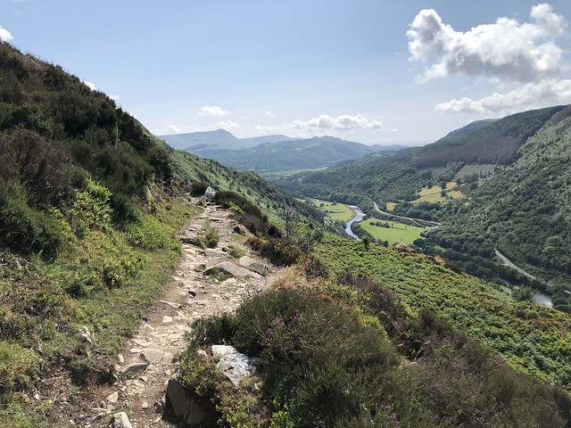
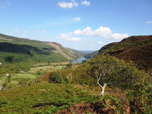
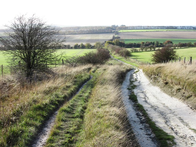
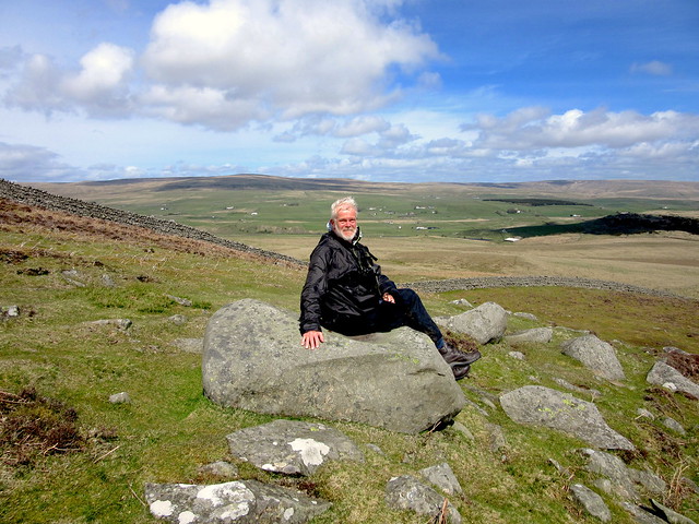
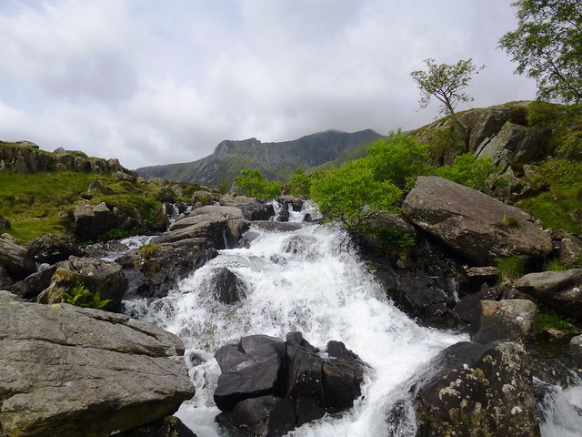
The outward leg from St Ives is one of the finest stretches of the South West Coast Path, a beautiful westward run of heath-covered headlands, granite cliffs and rocky coves where seals bob and fulmars wheel. Wild thyme lends a bitter-sweet fragrance to the grassy banks. Opposite the village of Zennor the coast path swings out onto Gurnard’s Head, a wild dragon-headed promontory with sheer cliffs that fall to sea-sculpted caves where the waves crash and boom. At Zennor, St Senara’s Church is home to the mermaid of Zennor, stiff and stark after 600 years as a carved bench end.

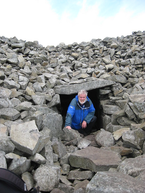
The homeward path follows the old Corpse Road footpath through the fields. This former route for bodies to be borne to Christian burial passes through a farming landscape that remembers its Bronze Age origins in the tiny size of the fields and the immense sturdiness and thickness of their walls. Each field is linked to its neighbour by a Cornish stile, a row of four or five well-spaced bars of granite set over a pit. It forms a grid barrier that baffles cattle and sheep – but not the sagacious local pigs, apparently.

Start/finish: Porthmeor Beach, St. Ives, TR26 1TG, (OS ref SW 516408)
Directions: SW Coast Path to Zennor; return by field path via Tremedda, Tregerthen and Wicca to Boscubben (473395); then Trevessa (481396), Trevega Wartha, Trevalgan (489402) and Trowan (494403) to Venton Vision (506407) and St Ives.

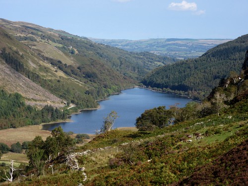
2. Corton Denham and Cadbury Castle, Somerset
7½ miles; OS Explorer 129

Not just a stroll through the green lanes and hills of south Somerset, this is a walk in the ghostly presence of King Arthur. The Macmillan Way lies just west of Corton Denham, and takes a northward course with an enormous view over a wooded vale leading to Glastonbury Tor, the summit tower a tiny pimple at the apex. The long line of the Mendip Hills closes the vista, with the green wedge of Brent Knoll 25 miles away in the west.

A clockwise loop around the mellow stone houses of Sutton Montis, and you follow the old greenway of Folly Lane across the medieval ridge-and-furrow to South Cadbury, tucked in the lee of Cadbury Castle’s great ramparted hill fort. A stony cart track climbs through the Iron Age ramparts to the wide, sloping summit of the hill. Did King Arthur, the ‘once-and-future King’, ever feast here with his warriors and his treacherous queen? An excavation in 1966-70 brought to light the foundations of a great aisled feasting hall, built in the early Dark Ages at the crown of Cadbury Castle. And spectral riders still sally forth from the fort at midnight, local stories say, their horses shod with silver that flashes in the starlight.

Start/finish: Corton Denham, Somerset DT9 4LR (OS ref ST 635225)
Directions: From Middle Ridge Lane (opposite church) footpath west to Corton Ridge (626224). North (Monarch’s Way) for 1 mile to road at Kember’s Hill (629241). Footpath through Sutton Montis to meet Leland Trail/LT (620252). LT to South Cadbury; right (632256), then right again, up to Cadbury Castle. Return to road; right; 100m past Crang’s Lane, path (633249, yellow arrow/YA) south to Whitcombe Farm and road (631237). Path below Corton Hill (‘Corton Denham’) back to Corton Denham.

3. Kingley Vale, near East Ashling, West Sussex
3 miles; OS Explorer OL8

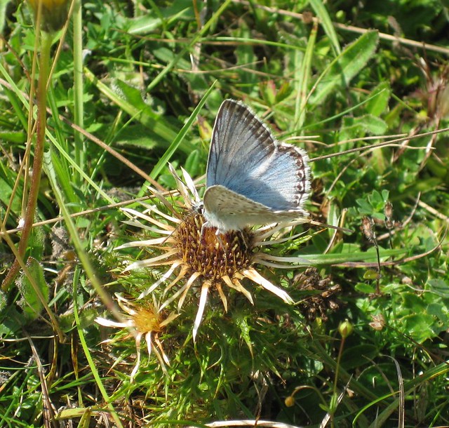
Every summer I look forward to a lazy walk in warm sunshine, up the track from West Stoke car park and round the waymarked circuit of Kingley Vale National Nature Reserve. It takes all afternoon to stroll these three miles, because Kingley Vale’s preserved chalk grassland is made for lingering and looking. It’s composed more of flowering plants than of grasses, a tight-packed sward rich in thyme and marjoram, with scabious, harebells, pink centaury, bird’s foot trefoil and dozens more species attracting clouds of blues, coppers, argus, browns and other butterflies.

By contrast, the sombre yew grove that colonises the steep east-facing slope on the west edge of the reserve seems barren of all life except that of its ancient occupants. This great grove, protected on its chalk slope, is a rare survival. The yew crowns are a green so dark it is almost black, but once in among them you find that their limbs are pale, brittle and twisted, like dried muscles. How old are these sombre, knotted trees? At least 500 years, but some of them are old enough to have seen druidical worship. Some could already have been standing many centuries at Kingley Vale when the upstart Romans came invading.

Start/finish: West Stoke car park (OS ref SU 825088), near East Ashling on B2178 near Chichester.
Directions: Through kissing gate; follow track north to kissing gate into NNR. Bear left on footpath just inside fence; follow uphill for 1/3 mile to yew grove on right (819105). Continue along waymarked path to make clockwise circuit of reserve.

4. Alfriston, Jevington and the South Downs, East Sussex
8½ miles; OS Explorer 123

Some walks just grab you so hard that you know you’ll be back to enjoy them again and again. I can never get enough of this beautiful circuit of East Sussex villages in the shadow of the South Downs.

Alfriston’s houses and inns are rich in carved timbers. On a sunny day the village lies in bright brick reds, acid greens and indigos. A flinty track runs east to pass below the Long Man of Wilmington, an ancient giant two hundred feet tall, his outline cut out of a chalk downland slope. A rutted woodland path leads on to Folkington, where pioneer celebrity chef Elizabeth David lies in the churchyard under a gravestone carved with aubergines, peppers and cloves of garlic. Then you head south on a snaking track to Jevington with its thousand-year-old church tower built like a fortress against Viking marauders. A Saxon Christ adorns the wall, victorious over a puny, wriggling serpent.

Crossing the downs on the homeward stretch, one marvels at how a corner of countryside with such a vigorous and bloody history – Viking and French raids, coastguard battles with the smuggling gangs, Second World War bombs and doodlebugs – has settled to a tranquillity as smooth as the applewood smoke rising from Alfriston’s chimneys into the blue Sussex sky.

Start/finish: Alfriston, East Sussex BN26 5UQ (OS ref TQ 521033)
Directions: Downland track east via Long Man of Wilmington (542034); Wealdway path via The Holt (551040) and Folkington church (559038) to St Andrew’s Church, Jevington (562015). South Downs Way west to Holt Brow (553019); Lullington Heath NNR via Winchester’s Pond (540020) to Litlington (523021). Left past Litlington church; just before Plough & Harrow PH, right (523017 – ‘Vanguard Way’) to Cuckmere River; right to Alfriston.

5. Latimer, Chenies and the Chess Valley, Bucks/Herts border
7 miles; OS Explorer 172

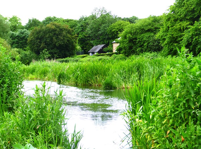
Of all the gorgeous walks within easy reach of London, this one never palls in any season. From Chalfont & Latimer tube station (Metropolitan line), Bedford Avenue and Chenies Avenue lead north into West Wood, where the Chess Valley Walk trail descends to cross the River Chess in its beautiful green valley under the neat estate village of Latimer. From here it’s a clockwise circuit, following the Chess Valley Walk above the shallow, winding river. ‘Mr William Liberty of Chorleywood, nonconformist brickmaker’ (died 1777), having refused a church burial, lies by the field path with his wife Alice in a brick-built tomb. Further on, you can buy a peppery, crunchy bunch of watercress from Tyler’s farm, before reaching Church End where astonishing 14th-century paintings adorn the village church.

Back across the River Chess, the Chiltern Way leads across lush wet pastures, then through woods of hornbeam and cherry to Chenies village. History lies thick on the great Tudor mansion of Chenies; and in the adjacent church generations of Russells, Dukes and Duchesses of Bedford, lie entombed. From here you follow a ridge path back to Chalfont, with glorious views across the Chess Valley.

Start/finish: Chalfont & Latimer tube station, Bucks, HP7 9PR (OS ref SU 997975)
Directions: Bedford Avenue; Chenies Avenue (996976); at Beechwood Avenue (996981), ahead into West Wood. Follow Chess Valley Walk downhill to leave wood and cross road (999985), then river (000986). Right to cross road (004987; ‘Chess Valley Walk’/CVW, fish waymark). Follow CVW for 1¾ miles to road (031990); on Sarratt Church (039984). Chiltern Way west to road (021980) and Chenies (016983); west via Walk Wood and West Wood to return to station.

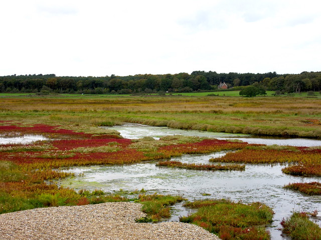
6. Dunwich and Dingle Marshes, Suffolk
6¾ miles; OS Explorer 231

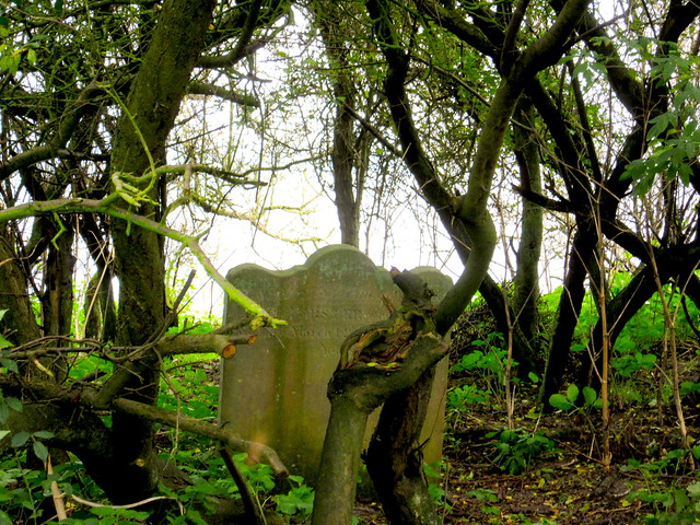
A perfect encapsulation of the moody magnetism of the Suffolk Coast. Dunwich was a great trading port whose churches, hospitals, squares and houses were utterly consumed by the sea. A path leads up to the solitary curly-topped headstone of Jacob Forster, still clinging to the cliff edge, the last relic of the church of All Saints that toppled to the beach in 1922.

The Suffolk Coast & Heaths Path runs north through copses of old oak and pine trees. Grazing marshes, dotted with black cattle, stretch away towards the long straight bar of the sea wall. Soon you are in among the great reedbeds of Westwood Marshes where tiny bearded tits bounce and flit through the reeds, trailing their long tails low behind them and emitting pinging noises like overstretched wire fences. There’s no view whatsoever of the nearby sea, just a haunting feeling of country walked by many, but known by very few.

Once across the Dunwich River, you top the shingle bank. Here is an instant switch of view and perspective, out over a slate grey sea and round the curve of the bay, as you follow the pebbly beach back to Dunwich under its sloping cliff.

Start/finish: Dunwich car park, Suffolk, IP17 3EN (OS ref TM 478706)
Directions: Ship Inn – St James’s Church and Leper Hospital (475706) – Bridge Farm (474707; ‘Suffolk Coast Path’/SCP). Little Dingle (475717) – Dingle Stone House (476724) to Great Dingle Farm (483730). Follow SCP arrows through Westwood Marshes to footbridge (495742, SCP) to shingle bank; right to Dunwich.

7. Lakenheath Fen, Norfolk/Suffolk border
7¾ miles; OS Explorer 228

All the famed dampness and richness of unspoilt Fenland are perfectly caught in this walk around Lakenheath Fen nature reserve. The path from Hockwold-cum-Wilton is by way of Church Lane, Moor Drove and the sluices and banks of the Little Ouse River, heading west into the reserve via its excellent Visitor Centre.

It’s hard to credit that this green and fertile fen landscape was intensively farmed carrot fields not so long ago. Dug out, planted with fen vegetation and provided with plenty of water, it has burst into life. Various waymarked trails lead through the reserve, with the Main Circular Trail as the spine. Otters thrive here, bitterns boom in spring among the reedbeds, kingfishers and water voles scud about. Cranes are nesting for the first time in centuries. Marsh harriers hunt the reedbeds and ditches on long dark wings, sailing the air with effortless mastery. Along the trail, detours lead to hides with privilege viewpoints over meres where great crested grebes perform their elaborate courtship rituals.

At Joist Fen the walk bears right to follow the bank of the Little Ouse back to Hockwold. A bunch of lucky cattle graze here, up to their chins in the lushest grass in East Anglia.

Start/finish: Hockwold-cum-Wilton, Norfolk IP26 4NB (OS ref TL 735880)
Directions: Church Lane; Moor Drove East (734876); cross sluice (731870); right along riverbank to B1112 (724868). Left; in 300m, right to Lakenheath Fen Nature Reserve Visitor Centre (718863). Follow Main Circular Trail/MCT (white arrows/WA) clockwise as far as Little Ouse river bank (698861). Right (Hereward Way) for 2 miles back to B1112 (724866). Left (take care!); retrace steps to Hockwold.

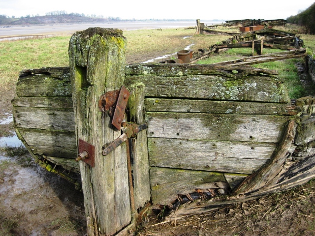
8. Purton and the Ships Graveyard, Gloucestershire
6½ miles; OS Explorer OL14

The River Severn comes down through west Gloucestershire in great wide loops, slowly broadening into its estuary. Boats that ply the river are few and far between these days, and the skeletons of some old Severn craft are one of the features of this fascinating walk.

From Brookend near Sharpness, field paths run north across the swell of the land to the tiny village of Purton on the edge of a big bend in the Severn. Through the village runs the long silver streak of the Gloucester & Sharpness Canal, dug across country at the turn of the 19th century to bypass some of the most difficult and dangerous bends of the river.

Dozens of old coal and cargo boats were brought here to Purton at the end of their working lives and rammed into the soft mud of the Severn’s east bank, to stiffen it and protect the adjacent canal against the fierce sweep of the tides. It’s a poignant walk back to Sharpness among the ribs and sternposts, tillers and rudders of these former river queens. And Sharpness itself is a fascinating rarity, a working river port where cranes clank as they unload cement and fertiliser from rusty old sea-going boats.

Start/finish: Brookend, Sharpness GL13 9SF (OS ref SO 684021)
Directions: Footpath north across fields for 1½ miles to Purton (682042). Cross canal; past Berkeley Arms PH (691045). Riverside path joins canal towpath (687044). Detour right along riverbank through Ships Graveyard, then canal towpath into Sharpness. Cross canal (670030); ‘Severn Way’ up steps; ahead past Dockers’ Club (671029) to road. Left across left-hand of 2 swing bridges (673029). Ahead to road (677026); right (‘Sharpness’). Left beside Village Hall (674021 – fingerpost); paths via Buckett’s Hill Farm to Brookend.

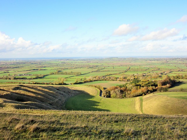
9. White Horse and Wayland’s Smithy, Oxfordshire
6 miles; OS Explorer 170

If you want to savour the deep history and mythology of these islands, you can’t do better than tramp the ancient Ridgeway across the chalk downs of Oxfordshire. Start from Woolstone, tucked in below the hills, and follow the field paths southwest via Knighton and Compton Beauchamp. From here you glimpse the White Horse that was cut out of the chalk turf high above some 3,000 years ago, still beautiful and enigmatic in her disjointed, futuristic form.

From Odstone Farm a sunken track leads uphill to reach the Ridgeway, already ancient when the White Horse was made, a rutted upland thoroughfare curving with the crest of the downs. Turning east along the Ridgeway you soon come to a remarkable monument, the great Neolithic long barrow of Wayland’s Smithy, its huge portal stones and grassy mound surrounded by a ring of tall old beeches. Wayland was a blacksmith in Norse mythology, and local tales say he’ll shoe your horse if you leave it overnight along with a silver coin. You don’t have to be a New Age devotee to sense the power and presence of the far past here.

A long mile along the Ridgeway brings you to the White Horse herself, and a descent down a steep breast of downland called The Manger to reach Woolstone.

Start/finish: Woolstone, Faringdon, Oxfordshire SN7 7QL (OS ref SU 293878)
Directions: cross Hardwell Lane – Compton House – just before Odstone Farm, left up Odstone Hill – left along Ridgeway. Wayland’s Smithy – detour to Uffington Castle and White Horse – continue on Ridgeway for ½ mile – left (308864) – Britchcombe Farm – cross B4507. On for ½ mile – left (308880) – path to Woolstone.

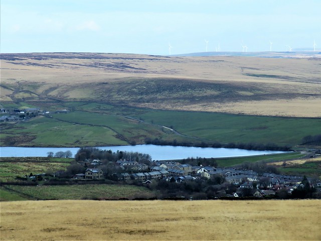
10. The Stiperstones, Shropshire
5 miles; OS Explorer 216
The Stiperstones stand stark and jagged. These quartzite outcrops rise from a heathery ridge at the northern end of the Long Mynd, Shropshire’s great whaleback of a hill. They are the focus of some of the most bizarre folk tales and superstitions in these islands.

The Shropshire Way leads up and past the Stones, heading north across heather moorland where cranberries make scarlet splashes of colour. This upland heath is carefully preserved for its wildlife value, with cowberry and crowberry among the great swathes of purple heather. You pass Cranberry Rock and Manstone Rock to reach the largest outcrop, the Devil’s Chair. When mist envelops the Stones, the Devil is in his Chair, waiting for Old England to sink beneath the earth. Impossible to tell how all these Gothic notions gained ground, but they lend the Stiperstones a very peculiar aura.

Views from the ridge are superb over the Shropshire hills and woods, east to the long green bar of Wenlock Edge, west as far as the borderlands of Wales. From Shepherd Rock a steep grassy path leaves the hill, descending steeply Past old lead-mine workings to Stiperstones village far below. From here a lower track leads back below the Stones, hard-edged and ominous along the eastern skyline.

Start/finish: Bog Centre car park, Stiperstones (OS ref SO 355979)
Directions: Shropshire Way from road (362976) past Cranberry Rock (365981), Manstone Rock (367986), Devil’s Chair (368991). From cairn just before Shepherd’s Rock (374000), steep descent to Stiperstones village (363004) and Stiperstones Inn. Return to Bog Centre via 361002, 359999, 361996 and lane parallel to the Stiperstones.

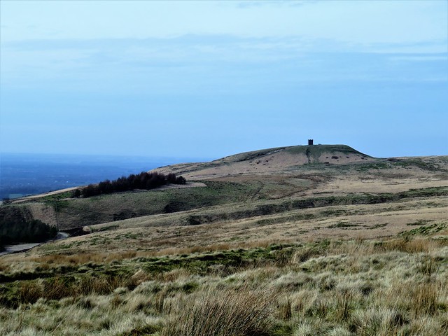
11. Kinder Edge, Derbyshire
9 miles; OS Explorer OL1

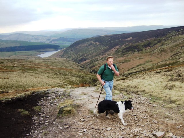
A hugely popular walk, and deservedly so. This is the ultimate memorial hike, commemorating the crowd of left-wing, working class youngsters from the industrial sprawls of Manchester and Sheffield who in 1932 initiated an incursion known as the Mass Trespass onto the privately owned moorland of Kinder. Some were imprisoned, others vilified. Without the impetus of their bold action, we wouldn’t have the right to roam over wild upland country that we enjoy today.

From Bowden Bridge near Hayfield you head north above Kinder Reservoir, looking across the valley to the long upstanding line of crags that form Kinder Edge. A steep climb beside the beck in rocky William Clough leads to the peat bogs of Ashop Head, where gamekeepers with sticks tried and failed to stem the mass trespass of 1932.

From here it’s a long and exhilarating stride south along the Pennine Way at the very edge of the gritstone escarpment, with magnificent views to Manchester and the distant hills of Wales. Across the watersplash of Kinder Downfall, and on to where the homeward path turns west off the Pennine Way at ancient Edale Cross and starts its descent down the long, long lane to Bowden Bridge.

Start/finish: Bowden Bridge car park, Hayfield, Derbyshire, SK22 2LH approx (OS ref SK 049870)

Directions: Continue up road. At Booth Sheepwash cross river (051876); in 100m, take path (yellow arrow). In 250m, left to reservoir gates; up cobbled bridleway on left. In 300m, left (054882, metal ‘bridleway’ sign) up to gate. Right (‘Snake Inn’) for 1½ miles (White Brow, William’s Clough) up to Ashop Head (065900). Right on Pennine Way along Kinder Edge for 3½ miles. Beyond Edale Rocks where PW turns left for Edale, right (081861) through gate; lane for 2¾ miles down to Kinder Road and car park.

12. Muker and Keld, Swaledale, N. Yorkshire
6½ miles; OS Explorer OL30

A classic walk in the Yorkshire Dales from the picture-book village of Muker. An old road, stone-surfaced and stone-walled, leads up the sloping fellsides. It heads northwest through sheep pastures to skirt the big open rise of Kisdon Hill before dropping gently down to Skeb Skeugh ford and the huddle of grey stone houses at Keld. I remember, many years ago, stumbling into Keld after a miserable day of rain and mist on the Pennine Way, and the bliss of a cup of tea and a pair of dry socks there.

From Keld the homeward path crosses the River Swale at the hissing waterfall of East Gill Force. A little further on and you pass tumbledown Crackpot Hall, undermined by subsidence in the lead mines of Swinner Gill. This is a sombre spot, resonant with history, a maze of spoil heaps, arched stone mine levels, and the precarious hillside trods or tracks of the miners.

It’s a remarkable contrast, walking south from these dolorous ruins above the fast-rushing Swale, down into the delightful green lushness of Swaledale and the stone-walled sheep pastures around Muker.

Start/finish: Muker, Richmond, N Yorks DL11 6QG (OS ref SO 910979)
Directions: Up lane by Muker Literary Institute. Forward; up right side of Grange Farm (‘footpath Keld’). Follow lane; then ‘Bridleway Keld’ (909982) up walled lane for ½ mile. Cross Pennine Way/PW and on (903986; ‘Keld 2 miles’) along bridleway to ford and B6270 (892006). Right into Keld. Right down lane (893012; ‘footpath Muker’). In 300 yards, left downhill (‘PW’) across River Swale, up to waterfall. Right (896011; ‘bridleway’) for ½ mile. 150m past stone barn, left (904009) to Crackpot Hall; path into Swinner Gill, to fingerpost (911012) opposite mine buildings. Sharp right (‘Muker’) to ford beck (911008); follow track down Swaledale for 1 mile. Cross Swale (910986); meadow path to Muker.

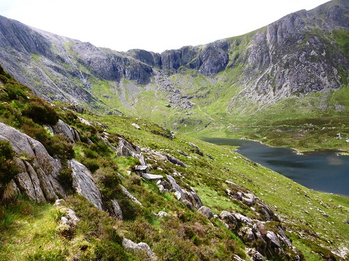
13. Cronkley Fell, Upper Teesdale, Durham Dales
7 miles; OS Explorer OL31

For its wonderful flowers and birds, this is my favourite springtime walk of all. You set off from Forest-in-Teesdale to cross the River Tees near Cronkley Farm. The peat-brown Tees comes charging down its rocky bed, roaring loudly and rumbling the stones as it races by. The valley meadows are full of nesting birds – lapwing, redshank and curlew – each with its own haunting cry, the very voice of spring in this wild place. Snipe go rocketing about the sky, divebombing with a drumming rattle of outspread tail feathers.

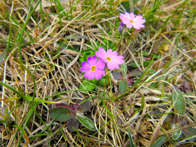
From Cronkley Farm the Pennine Way climbs southward to meet the old lead-miners’ road called the Green Trod. Turning west along this grassy broad track, you are soon in flowery heaven up on the nape of Cronkley Fell. Tiny white flowers of lead-resistant spring sandwort flourish in abandoned mine workings. Higher up you find the real jewels of this rugged, enchanting valley – tiny, delicate Teesdale violets, miniature bird’s-eye primroses as shocking pink as a starlet’s fingernails, and royal blue trumpets of spring gentians.
A picnic pause to contemplate the forward view over the basalt crags of Falcon Clints, and you descend through pungent-smelling juniper bushes to turn for home along the brawling Tees once more.

Start/finish: Forest-in-Teesdale car park, near Langdon Beck, Co. Durham DL12 0HA (OS ref NY 867298)
Directions: Right along B6277; in 100m, left down farm track via Wat Garth, to cross River Tees by Cronkley Bridge (862294). Follow Pennine Way (PW) past Cronkley Farm, up rocky slope of High Crag and on along paved track. In 500m, left across stile (861283). PW bears left, but continue ahead uphill by fence. Through kissing gate (861281); in 100m, right along wide grassy trackway. Follow it for 2 miles west across Cronkley Fell (occasional cairns). Descend at Man Gate to River Tees (830283); right along river for 2½ miles. At High House barn (857294), half-left across pasture to Cronkley Bridge; return to car park.

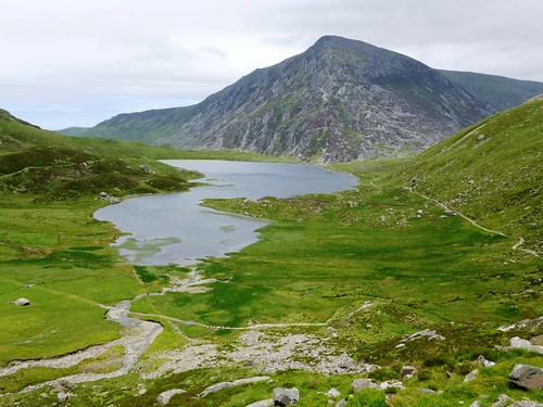
14. Mellbreak, Mosedale and Crummock Water, Lake District
6 miles; OS Explorer OL4

This delectable circuit offers all the delights of Lakeland in one go – a steep (but not too steep) fell, a little-visited side dale, and a gorgeous lakeside stroll back to one of the best pubs in Cumbria.

From the Kirkstile Inn a country road runs south. A little way past Kirkgate Farm a path heads off, straight up the northern face of Mellbreak. The fell looks tremendously steep; but in fact the path is clear once you’re on it, and with a bit of zigzagging and a modicum of hard breathing you’re on the top of this rugged mini-mountain almost before you know it. The view is one of the finest in the Lake District – north across the Solway Firth to the distant hills of Galloway, east to the pink screes of Grasmoor across Crummock Water, south to the magnificent humpy spine of Red Pike, High Stile and High Crag.

Gaze your fill; then drop down west into green and silent Mosedale, boggy and orchid-spattered. ‘Dreary,’ opined Alfred Wainwright. For once, the Master was wrong. Head south along Mosedale, round the end of Mellbreak, and finish with a glorious stroll north up the side of Crummock Water with a feast of fells all round.

Start/finish: Kirkstile Inn, Loweswater, Cumbria CA13 0RU (OS ref NY 141209)
Directions: From Kirkstile Inn, south on lane past Kirkgate Farm for ½ mile. At gate (139202), up through trees, then to foot of scree (141199). Bear left; zigzag steeply up to Mellbreak’s northern summit (143195). Forward for 500m to dip and fork in path (145190); bear right, steeply down to path in Mosedale (141186). Left (south) for ¾ mile to gate in fence (146175); down to track by Black Beck (146174); left (east) to Crummock Water. Left (north) to north end of lake. Bear left (149197) to wall (148199); follow to Highpark Farm (145202). On to cross Park Bridge (145205); fork left to Kirkstile Inn.

15. Holy Island, Northumberland
10 miles, OS Explorer 340
NB Causeway and Pilgrim Path are impassable 2½ hours either side of high tide. Tide times posted by causeway; also at lindisfarne.org.uk

Pilgrims have been crossing the sands for a thousand years to reach Lindisfarne or Holy Island,  monastic retreat of the 7th century hermit bishop St Cuthbert. The pilgrim path to Lindisfarne, marked out by tall poles, diverges from the causeway road to cross the murky sands. It’s a squelching walk, windy and redolent of salt mud and seaweed, passing a long-legged refuge tower for unwary travellers caught by the incoming tide. Often you can hear the eerie singing of seals on the distant sands.

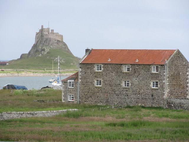
Once ashore on Holy Island, the little village with its great red sandstone monastic ruins is fascinating to explore. Down off the southwest corner lies tiny, tidal Hobthrush Island, with the sparse remains of an ancient chapel marking the site of the cell where Cuthbert sought even greater privacy.

A circular walk round Holy Island by way of Lindisfarne Castle on its dolerite crag and the nearby garden laid out by Gertrude Jekyll, and then back along the pilgrim path to the mainland, savouring the solitude of this vast expanse of tidal sand under enormous skies.

Start/finish: Holy Island causeway car park, Northumberland (OS ref NU079427)
Directions: Follow sands route (post markers) to Holy Island. Right to village and monastery. Walk anti-clockwise round island: harbour, castle, Gertrude Jekyll’s Garden (136419), The Lough, path west beside dunes. At gate by NNR notice (129433), left down track to village, or ahead for ½ mile, then left (122433) to causeway and sands route.

16. Worm’s Head, Gower Peninsula, South Wales
4 miles there-and-back; OS Explorer 164
NB Causeway is accessible for 2½ hours either side of low tide. Tide times at tides.willyweather.co.uk. Please don’t venture as far as Outer Head between 1 March and 31 August – nesting birds!

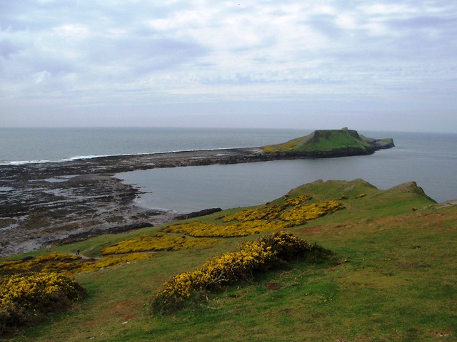
Norsemen named Gower’s double-humped promontory ‘wurm’, meaning dragon or serpent, and Worm’s Head does resemble a massive green monster heading out to sea. This is a wildly exhilarating scramble, spiced by the knowledge that you have to get your tide timings right. If you don’t, you’re in good company – Dylan Thomas once got himself marooned here.

From the National Trust car park at the western tip of the Gower peninsula you follow the cliffs out to the rough and rugged causeway crossing. There are blennies and crabs in the rock pools, and canted blades of barnacle-encrusted rock to cross before you can scramble up onto Inner Head, the middle section of the promontory. A path leads among pink flowerheads of thrift to the square wave-cut arch of the Devil’s Bridge, across which you make your way (but not in nesting season) onto the furthest hummock, Outer Head. Here kittiwakes, fulmars, guillemots, razorbills and puffins fill air and sea with their cries, flights and incredible guano stink.

Start/finish: Rhossili car park, Gower (OS ref SS 415880)
Directions: Walk ahead past National Trust information centre, following track and descending to cross causeway. Follow path round south side of Inner Head, across Devil’s Bridge (389877), round south side of Low Neck, out to Outer Head.

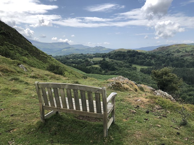
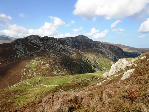
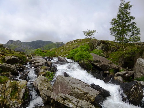
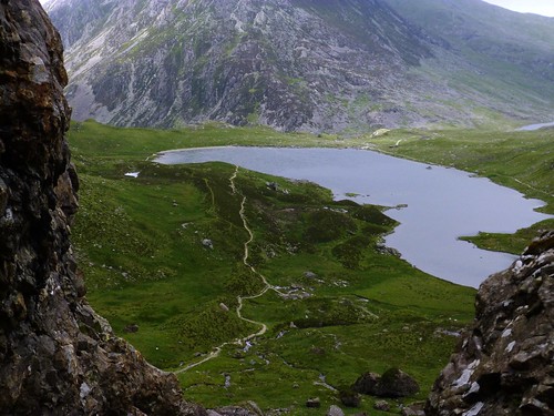
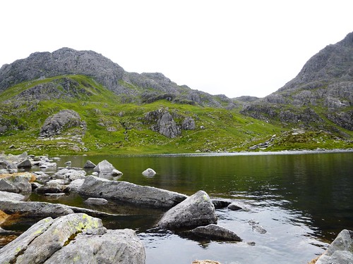
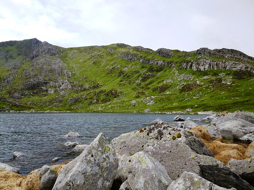
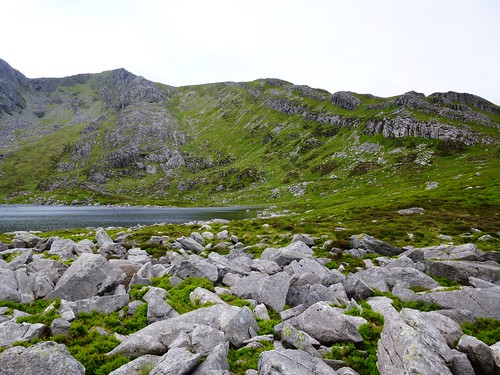
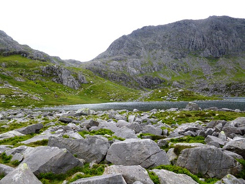
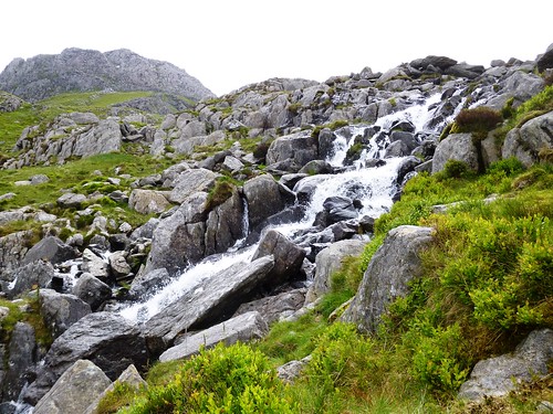
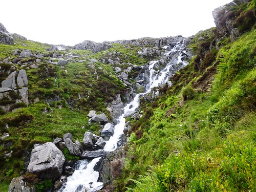
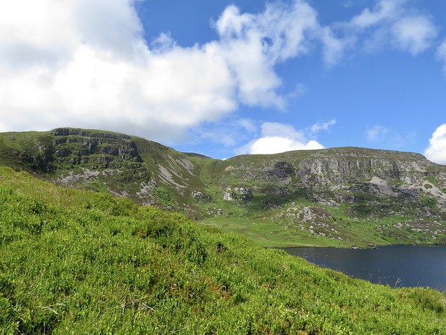
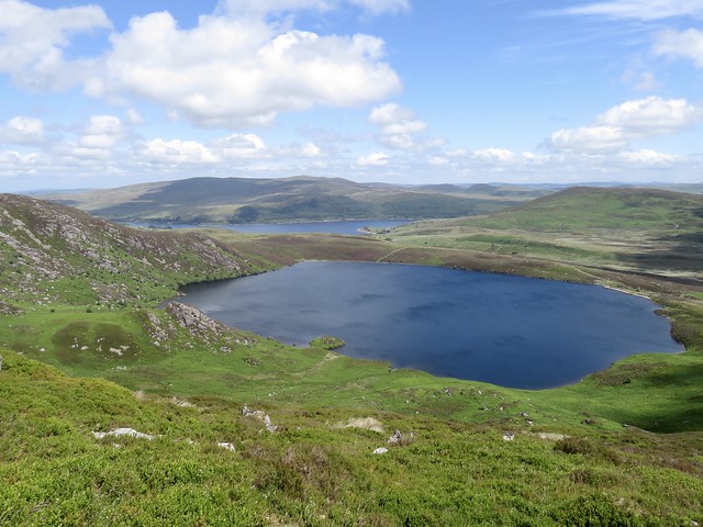
17. Llyn Bochnant and Cwm Idwal, Snowdonia, North Wales
6½ miles; OS Explorer OL17

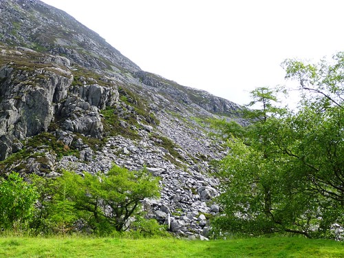
Cwm Idwal is justifiably one of the most popular spots in Snowdonia – a readily accessible, highly dramatic bowl of crags cradling the dark lake of Llyn Idwal. Just above in a hidden valley lies another lake, Llyn Bochlwyd, far less frequented, from which you descend into Cwm Idwal by a steep and beautiful path.

The trail starts from Cwm Idwal car park (on A5 between Capel Curig and Bethesda) up a stone-pitched track. After 400m you leave the crowds behind, forking left onto a path that climbs the steep chute of Nant Bochlwyd beside a tumbling stream. Up at the top under the grim crags of Glyder Fach lies Llyn Bochlwyd, in a silent hollow of bilberry and grass. A spot to sit and savour before skeltering down the precipitous path to Llyn Idwal far below. Look out hereabouts for the white bib and harsh rattling chirrup of the ring ouzel, a mountain blackbird rarely seen.

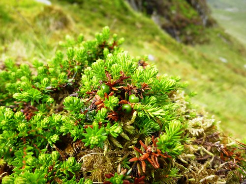
A path circles Llyn Idwal, running high up under the crags of Glyder Fawr. Among the big boulders here grows starry saxifrage, delicate and white, and the miniature green blooms of alpine lady’s mantle, a lovely carpet of mountain flowers.

Start/finish: Cwm Idwal car park, Nant Ffrancon, LL57 3LZ (OS ref SH 649603)
Directions: Up stone-pitched path at left side of Warden Centre. In 350m path bends right (652601); ahead here on stony track across bog; steeply up right side of Nant Bochlwyd to Llyn Bochlwyd (655594). Right (west) on path for 400m to saddle (652594); then steeply down to Llyn Idwal (647596). Left along lake. At south end take higher path (646593) slanting up to boulder field; take care fording torrent at 642589! At big 20-ft boulder (640589), go right down side of boulder; left across rocky grass to homeward path (640590), steep in places.

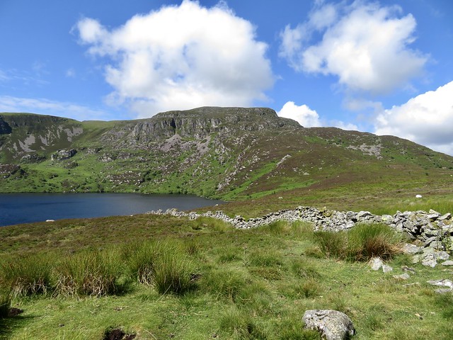
18. Creag Meagaidh NNR, Inverness-shire, Scotland
8½ miles; OS Explorer 401

A classic there-and-back walk among the Scottish mountains, rising up a flowery glen to a hidden corrie. If you’re longing for the day you can take a picnic out among the hills again, squirrel this splendid walk away in your wish list.

Creag Meagaidh National Nature Reserve car park lies on the A86 between Spean Bridge and Kinloch Laggan. A trail marked with otter symbols leads past buildings and up steps to a sign for ‘Coire Adair’, the start of the walk up the bow-shaped glen. At first the path runs among woods of young birch, alder and oak. The boggy hillsides are dotted with heath spotted orchids, the hair-like stems and bright blue flowers of insectivorous butterwort, and purple blooms of wood cranesbill.

Once beyond the trees, mountains hem you round, the Allt Coire Adair burn tumbles down its snaky bed, and the path rises gently across open moorland tufted with bog cotton. At the top of the glen you surmount the hummock of a glacial moraine, and a prospect opens down onto the little glassy lakelet of Lochan a’Choire under a curving wall of black cliffs, lonely, wild and utterly silent.

Start/finish: Creag Meagaidh NNR car park, PH20 1BX (OS ref NN 483873)
Directions: From car park follow red trail (otter symbol). In 500m pass to right of toilets/buildings (479876). Follow path on the level, then up steps; fork right at top (474879; ‘Coire Ardair’) on clear stony path for 3 miles to Lochan a’ Choire (439883). Return same way.

19. Hermaness, Isle of Unst, Shetland
5 miles; OS Explorer 470

One of the most dramatic springtime walks I know, and certainly one of the remotest, Hermaness is a place apart. This blunt headland forms the northernmost tip of the Isle of Unst, itself the most northerly island in Britain. You set out literally from the end of the road, climbing a well-marked path that circles round the headland. The first inhabitants you meet will be the bonxies or great skuas, big clumsy gull-like birds that defend their nests and fluffy chicks by screaming and flying at you – though a stick upheld will deflect them.

It’s a rugged welcome to Hermaness, but this is a rugged place of bog, tiny lochs and tremendously craggy cliffs. The dramatic showpiece suddenly appears as you breast the rise and look down over a line of enormous sea stacks, great canted blades of rock jutting out of the sea. Their sheer dark slopes are whitened by the tens of thousands of gulls, fulmars, kittiwakes and guillemots that circle restlessly far below. Rumblings, Vesta Skerry, Tipta Skerry, Muckle Flugga with its stumpy lighthouse, and the little round button of Out Stack – these are the full stops that top off the mighty travelogue of Britain.

Start/finish: The Ness parking place, Burrafirth, Isle of Unst (OS ref HP612147)
Directions: From Ness parking place at end of road, follow marked circular path (green-topped posts) round Hermaness. Allow 2-3 hours. Remote, windy, boggy and slippery underfoot: dress warm and dry; walking boots. Take great care on cliff edges. Bring binoculars and stick. Information leaflets in metal box at start of path. NB: Great Skua (‘bonxie’) dive-bombs during chick-rearing season, generally late May until July, coming close but rarely striking. To deter, hold stick above head. Please avoid Sothers Brecks nesting area, May-July.

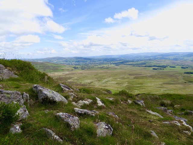
20. Slieve Gullion, Co. Armagh, Northern Ireland
5 miles there-and-back; OSNI Discoverer 29; walkni.com

Slieve Gullion rises over South Armagh, a kingly mountain, a great volcanic plug that dominates the landscape for miles around. This is a mountain of myth and legend, with a sensational 100-mile view from the summit as a reward for the not-very-demanding climb.

From Slieve Gullion Forest Park car park (signposted on the Drumintee Road between Newry and Forkhill) there’s a well-walked trail (‘Ring of Gullion’ waymarks) rising in stages via forest roads and tracks, clockwise round the southern slopes of Slieve Gullion. In a couple of miles you bear right at an upper car park, a short steep upward puff that lands you on the south peak of the mountain.

The prospect is simply sublime. A great volcanic ridge of hills encircles the mountain, with views beyond as far as the Mourne Mountains, the Antrim hills, the billowy Sperrins, and the green and brown midland plain running south to the tiny silhouettes of the Wicklow Hills beyond Dublin, a hundred miles away.

Explore the Neolithic passage grave on the peak, then picnic by the Lake of Sorrows. But don’t touch the enchanted millstone that lies half-submerged there. It might bring forth the dreaded magical hag, the Cailleach Beara, and you wouldn’t want that.

Start/finish: Slieve Gullion Forest Park car park, Drumintee Road, Killeavy, Newry, Co. Armagh BT35 8SW (OS of NI ref J 040196)
Directions: From top left corner of car park, left up path through trees. In ¼ mile join Forest Drive (038191), up slope, then level, for ¼ mile to ‘Ring of Gullion Way’ post on left (035190). Right up drive, past metal barrier; left uphill for 1½ miles to car park (018200). Beyond picnic table, right at white post, steeply uphill. South Cairn (025203) – Lake of Sorrows – North Cairn (021211); then return.

 Posted by at 15:30
Nov 112017


First published in: The Times Click here to view a map for this walk in a new window
picture picture picture picture picture picture picture picture picture picture picture picture picture picture picture
Facebook Link:

Llandudno is a great traditional seaside resort, and proud of it. Giciante Ferrari and his Performing Birds and high diver Walter Beaumont share equal billing with Sir Malcolm Sargent and Matthew Arnold on a ‘Notable People Who’ve Stayed Here’ plaque on the promenade. The high Victorian hotels stand draw up in a long line around the curve of the bay, buttressed by the two bulbous headlands of Great and Little Orme and backed by the distant mountains of Snowdonia. It all made a fine setting for our walk to explore the rugged charms of Great Orme, where the National Trust own a major piece of land, Parc Farm, at the heart of the Great Orme Country Park.

The peace of a cold, cloudy morning lay over Happy Valley gardens as we climbed their pathways, then on up steps to the crest of a natural limestone amphitheatre. How proud those Victorian holidaymakers must have felt of their civilisation as they wandered the gardens among Scots pine, palm trees, rockeries and flower borders, looking down over the pier to the sparkling white arc of the town, and up to the mountainous Orme above, all ‘savage nature wild and rude’.

Great Orme is a giant lump of limestone, in profile like a barking dog with muzzle raised to the northwest. Paths and tracks crisscross it, legacy of leisure walking and of the quarrymen and copper miners who dug it for stone and ore since back in the Bronze Age. We set out on an anticlockwise circuit of the top in the teeth of a strengthening wind, past the farmhouse of Penmynydd Isa and Powell’s Well, down to St Tudno’s church perched above the sea. In the sprawling graveyard the names of Jones and Davies, Williams, Roberts and Evans adorn black slate slabs. Inside we found intricate medieval Celtic stonework, and a fine dragon snarling in the shadows above the chancel window.

We headed west from St Tudno’s towards the Orme’s seaward snout over a moor patched with limestone pavement and scattered with big erratic boulders left there by the retreating glaciers ten thousand years ago. The fat sheep of Parc Farm stood munching heads down in a walled beanfield. The wild goats of the headland were keeping out of sight today, but close under the cable car station at the summit we caught their pungent whiff.

On over the brow of Bishop’s Quarry where hundreds of lovers, rogues and wanderers have spelt out their names in white limestone fragments. A sensational view over the Conwy estuary to the packed mountains of Snowdonia, stamped on a stormy sky in flat grey-blue silhouettes as though cut in profile from the lead and slate they are founded on. And then the skeltering path of the Zig Zag Trail, steeply down through windblown heather, rocks and cliffs to the gentle pathways of Haulfre Gardens and Llandudno’s promenade once more.
Start: Happy Valley Road, Llandudno Promenade, LL30 2LR (OS ref SH 782828)

Getting there: Rail to Llandudno.
Road – Llandudno is signposted off A55 between Colwyn Bay and Conwy

Walk (6 miles, moderate, OS Explorer OL17): Opposite Grand Hotel front door (782828), up Alex Munro Way to Happy Valley Gardens. Path up left side of lawns; follow Happy Valley Summit Trail (‘To Summit’/TS arrows, blue-ringed posts/BP) to top of gardens (780831). Up steps beside ski slope area; on across heath to Penmynydd Isa farmhouse (774834). On to St Tudno’s Church (770838). Up road towards summit; 100m beyond top of graveyard, fork right (TS, BP). In 150m (768836) right along gravel track, then grassy path, keeping wall on your left, for 1½ miles anti-clockwise to SE corner of wall (765831), just below summit station. Bear left to see pebble signatures and Bishop’s Quarry; return to wall corner; follow track past yellow-ringed post to brow of hill. Bear half right over ridge; aim half left for post near erratic boulder (769828). From here follow Zig Zag Trail (‘To Town’, black-ringed posts) steeply down to tarmac path by shelter near sea level (772823). Left via Haulfre Gardens to Promenade.

Lunch: Haulfre Tearooms, Haulfre Gardens LL30 2HT (01492-876731)

Accommodation: St George’s Hotel, The Promenade, Llandudno LL30 2LG (01492-877544, stgeorgeswales.co.uk) – welcoming, traditional seafront hotel.

Parc Farm: nationaltrust.org.uk/projects/wildlife-and-farming-on-the-great-orme

Great Orme: greatorme.org.uk; conwy.gov.uk/thegreatorme

Info: visitllandudno.org.uk; satmap.com; ramblers.org.uk

 Posted by at 02:45

Books


Walking the Bones of Britain is the story of a thousand-mile journey through the rocks and landscapes of the British Isles, unrolling over three billion years. It starts in the Outer Hebrides at the northwest tip of Scotland among the most ancient rocks in the land, formed in fire and fury when the world was still molten. And it finishes a thousand miles away in the southeast corner of England, where nature and man are collaborating to build new land.

In between, an incredible journey along footpaths and byways, moving from melted rock to volcanic upheaval, the clash of continents, mountain ranges rising and falling, seas invading and retreating, lands ripped apart and oceans snapping shut. In the evidence of the rocks under our feet and the landscapes around us we find life forming and flourishing, snuffed out by crashing asteroids, sent packing by ice sheets a mile thick, flooding back by land and sea.


In my workroom is a case of shelves that holds 450 notebooks. Their pages are creased and stained with mud, blood, flattened insect corpses, beer glass rings, smears of plant juice and gallons of sweat. Everything I’ve written about walking the British countryside has had its origin among these little black-and-red books.

During the lockdowns and enforced idleness of the Covid-19 pandemic, I began to revisit this rough treasury of notes, spanning forty years of exploring these islands on foot. The View from the Hill pulls together the cream of this well-seasoned crop, following the cycle of the seasons from a freezing January on the Severn Estuary to the sight of sunrise on Christmas morning from inside a prehistoric burial mound. In between are hundreds of walks to discover randy natterjack toads in a Cumbrian spring, trout in a Hampshire chalk stream in lazy midsummer, a lordly red stag at the autumn rut on the Isle of Mull, and three thousand geese at full gabble in the wintry Norfolk sky.
https://www.hauspublishing.com/product/the-view-from-the-hill/


Our War Paperback – Unabridged
‘Our War – How the British Commonwealth Fought the Second World War’ tells the extraordinary story of the men and women of the British Commonwealth, from many nations all over the world, who volunteered to fight alongside Britain during World War Two.

How did people of all kinds, races, religions and ways of thinking come together like this? Why did young men and women from Trinidad and Australia, India and Canada, Seychelles, Kenya and New Zealand put themselves at risk thousands of miles from home? Why did they feel so strongly attached to Britain, the ‘mother country’? And how were their lives and attitudes changed by their experiences?

From the jungles of Burma and the night skies over Berlin to the icy waves of the Arctic convoys, the blitzed streets of London and the hellish PoW camps of Borneo and Poland we follow them. Survivor’s guilt, immense pride, PTSD, stoicism and bitter anger: all these are here, in the words of people who never dreamed they would find themselves at the cutting edge of war.

I travelled round the world in the nick of time to catch the experiences of these elderly survivors of many nations. This is the one and only only record of their service and its aftermath.

‘Our War – How the British Commonwealth Fought the Second World War’, published by Weidenfeld & Nicolson 16 April 2020 in paperback and audio.

Our War


Ships of Heaven – The Private Life of Britain’s Cathedrals is the story of Britain’s flotilla of cathedrals, tossed on waves of power and glory, scandal and mayhem for a thousand years. Nowadays these great stone ships seem as solid and unshakeable as any Rock of Ages. But they are leaky old vessels in uncharted waters. They creak and groan, they fail and founder, then resurface against all odds. Theirs is a thrilling saga of crisis and boldness, of ruin and revival.

Ships


The January Man (paperback edition)
The January Man (shortlisted for Wainwright and Richard Jefferies prizes) – Christopher’s much-praised account of a year’s walking and nature watching in Britain, out in paperback.

JanMan
The January Man
The January Man is the story of a year of walks that was inspired by a song, Dave Goulder’s ‘The January Man’. Christopher describes the circle of the seasons around the British Isles, each month in its own unique setting – January in the winter floodlands of the River Severn where he grew up, March in the lambing pastures of Nidderdale, May amid the rare spring flowers of Teesdale, June along towering seabird cliffs on the remote Shetland island of Foula, September among the ancient oaks of Sherwood Forest. Flowers and birds, sensational landscapes and remote corners of country, winter and rough weather, shepherds, musicians and farmers, Robin Hood and the Green Man – they’re all here in this powerful evocation of the countryside, its treasures and secrets, and its cycle of life, death and rebirth.

The walks and landscapes of The January Man are interwoven with meditations on the relationships between people of Christopher Somerville’s post-war generation and their reticent fathers. Christopher’s father John, a senior civil servant at the secret GCHQ establishment in Cheltenham, never spoke about his work or his wartime experiences. But he was a great walker during his lifetime, and it was through walking and talking that he began to open up to his son as they drew closer to one another. As he walks the land through the cycle of the seasons, ten years after John’s death, Christopher comes to appreciate and understand the man that his father really was, as he reflects on the circle of his life.

JanMan


Times Britain’s Best Walks (paperback edition)
Times Britain’s Best Walks – 200 walks all over these islands, this paperback edition offers the cream of Christopher’s long-running ‘A Good Walk’ column in The Times.

BBW
The Times Britain’s Best Walks
At long, long last! – 200 of the best of Christopher’s ‘A Good Walk’ walks from The Times, gathered between covers. Lovely photos (many by Christopher’s wife Jane), maps, detailed directions, where to eat/drink etc., how to get there – and of course, Christopher’s lyrical descriptions of landscape, nature, history and people.
TTBBW

Traveler Ireland
A 4th edition of this top-selling guidebook to Ireland is just out.
‘This book and Map was amazing!! It had EVERTHING on it. I took 4 guide books with us; Rick Steve’s, Ireland for Dummies, Back Roads of Ireland, and this one. I never used any of the other books but this one. It have everything we needed and more. The other books seemed to be promoting areas that were not that great, This book highlighted some of the most amazing places that were off the beaten path of the main tourist areas.’ – Amazon review of 3rd edition by ‘Samantha’, 1 July 2014.

travi

Somerville’s 100 Best Walks
Hooray! Haus Publishing have produced a new paperback of ‘Somerville’s 100 Best Walks’, a collection (first published in 2009) of some of the best walks I did during my 17-year stint as Walking Correspondent of The Daily Telegraph. Entitled ‘Somerville’s 100 Best British Walks’, the new version (in weatherproof laminated covers) is smaller, lighter and more handy, but still contains all the walks complete with their wonderful hand-drawn illustrated maps by Claire Littlejohn.

100

Where To See Wildlife In Britain And Ireland
‘Where To See Wildlife …’ brings together the very best places you can see wildlife in Britain and Ireland – 826 of them, from famous national nature reserves to local sites, hillsides, woodlands, marshes and mountains.

The wildlife of the British Isles is just about the most diverse and fascinating in the world for such a small archipelago. Chalkhill blue butterflies, early purple orchids, golden eagles, spawning salmon, otters, thousands of insects and fungi … We value and admire these beautiful creatures and plants – but where can we actually find them? Where, near your house or your holiday cottage or campsite, can you go to smell a fragrant orchid, see a rare large blue butterfly mating, or hear the roar of a rutting stag or the babble of ten thousand dunlin on a tideline? ‘Where To See Wildlife …’ tells you exactly where.

Each of these sites is individually and evocatively described, and enhanced with how-to-get-there directions, conservation designations, and information on facilities, refreshments and much else. Superb colour photos and maps, too.


This book is a practical tool as much as a treasure-chest of descriptions. Keep it in the car or by the bed; take it with you on holiday or work trips; put it in with the bird-watching binoculars and walking boots.

Wildlife

Traveler Great Britain
A new edition (the 3rd), part of the very highly respected National Geographic Traveler series, which I’ve updated and enhanced with lots of ‘Experience’ and ‘Tips’ panels – how and where to experience everything from watching a cricket match to joining in a Scottish ceilidh, hunting for Ice Age flora to taking a guided walk in Snowdonia.

Great Britain

Traveler Ireland
A new edition (the 3rd), part of the very highly respected National Geographic Traveler series, which I’ve updated and enhanced with lots of ‘Experience’ and ‘Tips’ panels – how and where to experience everything from
discovering Dublin’s great pubs to viewing the gable-end murals of Belfast, and from cookery classes at famed Ballymaloe in Counbty Cork to taking a seaweed bath in County Mayo!

Ireland

The Golden Step
Christopher’s much-acclaimed account of his 300-mile walk across Crete has gone into another, larger-format edition.

Golden Step

Walks in the Country near London
New and improved – 25 walks from railway stations (4 of them new, all of them re-walked – thank you for your help, Ruth!) in the beautiful countryside just outside London. Kentish apple blossom, Surrey lanes, Buckinghamshire beech woods, Essex wildfowl creeks – they’re all here.

walksnearlondon.jpg

Somerville’s Travels’ (AA Publishing – see below), Christopher’s account of 20 journeys at slow pace through Britain from Land’s End to Shetland, has been reissued as an ebook with a new and maybe better title – ‘Slow Travels Around Britain’. Here’s your chance to kick back with Christopher on your Kindle!

slowtravels.jpg

Britain and Ireland’s Best Wild Places
‘A gloriously idiosyncratic guide … Reading him, you want to get out, get walking, get looking’ (Robert Macfarlane, Sunday Times)
‘Brilliant and heartfelt … magnificent … an extraordinary work’ (Sunday Telegraph)
‘An excellent survey .. informative and poetic’ (Financial Times)
‘Utterly charming … a wonderful book and elegant reference guide’ (Irish Times)


That’s what the critics said about Christopher’s best-selling guide to 500 wild excursions, ‘Britain and Ireland’s Best Wild Places’. Now it’s out in paperback!

500.jpg

Never Eat Shredded Wheat, Christopher’s acclaimed gallop through the Geography of the British Isles (complete with Pub Quiz, naturally), is out in paperback! Here’s what the critics said:

‘This is geography not as a dry academic subject full of jargon and terminology, but as the natural history of a living, evolving landscape.’ (Economist )

‘This neat and engaging book will remind you of the geography of our green and pleasant isle, and, aside from anything else, will ensure you are never without the correct fact again’ (The Oldie )

‘Let’s lift our heads from the flat, mechanical, simplistic world inside the video screens and feast our five senses on the earthly delights of real geography where it rules supreme: out there.’ (Sunday Express )

‘An amusing and informative read.’ (Sunday Telegraph )

‘Packed with a wealth of information – making it a must for fans of pub quizzes. And it’s good to know someone else was taught that Great Britain looks like an old lady riding a pig’ (Press Association )

‘This book is brilliant…you will find explanations and descriptions of every nook and cranny of our nation.’ (The Sentinel )


‘A sort of Lynne Truss for our geography, by the author of COAST.’ (The Bookseller )

Never Eat Shredded Wheat

Walking has never been a more popular pastime and nowhere is more beautiful for walkers to explore than Ireland. In this beautifully written and superbly researched guide, Christopher Somerville draws on his very popular column for the “Irish Independent”, to present 50 of the very best walks in Ireland – from the Nephin Beg Mountains in Sligo in the North to Dingle Way in Kerry in the South. Practical instructions for the walks are married with evocative and informative passages on the history, flora and fauna, culture and topography of the land. Whether it’s exploring the Burren in its floral glory or seeing the Walls of Derry, or even sitting at home in your armchair planning your next walk, this book will prove popular with walkers, holiday makers and anyone who loves the Irish landscape.

Walking in Ireland.jpg

I’ve written Never Eat Shredded Wheat for everyone who – like me – found schoolroom Geography a boring parade of facts and figures, or who has forgotten most of what they did learn, or who has come to rely so heavily on Sat Nav that they’ve stopped noticing the landmarks that make our wonderful country such a pleasure to explore. We are so insulated from the real world when we’re in the car, plane or train, so plugged into iPods, stereos, CDs, phones and laptops, that we are in danger of becoming the best-travelled and worst-orientated Britons ever known. Let’s reconnect with the Geography of our islands – their look and feel, what made them and shaped them, where everything is, and why it’s there. Let’s celebrate the journey, and let’s arrive enriched and bewitched, with all our five senses tingling!
Never Eat Shredded Wheat takes you exploring the coasts and islands, the rivers and rocks, the cities and counties of Britain, from the Thames Estuary to the Irish Sea and from Rockall to Land’s End. It’s packed with facts and stories, anecdotes and jokes and ‘did-you-know’s. There’s a huge, 200-question Pub Quiz to test your knowledge and get one up on your friends. And the whole book is delightfully illustrated with maps and cartoons by my long-term collaborator Claire Littlejohn.

nesw.jpg


This book tells the story of 20 journeys- mostly on foot, but also by bicycle, branch line train, bus, narrowboat and ferry – across very special areas of Britain. Here are remarkable landscapes, travelled by the unfrequented ways that reveal their unique characters – the ancient Cornish coast wrapped in mist, the South Country downs threaded by the oldest road in Britain, post-industrial Birmingham and Stoke explored by canal, the Cheviot Hills on the tracks of cattle-thieves, musicians and murderers, the Shetland Isles and the northernmost point of our idiosyncratic archipelago. Illustrated throughout with colour photos, most taken by Christopher on his journeys.

travels.jpg


Christopher Somerville has been walking, exploring and writing all over the world for 30 years, and as the Walking Correspondent of the “Daily Telegraph” has written the “Walk of the Month” for over 15 years. This is his selection of his 100 favourite walks. They are to be read individually, as they are a true traveller’s observations of people, places, moods and reflections as they strike him. As a collection, they take the reader on a vivid, moving and unforgettable adventure through Britain, from the A of Angus Glens to not quite the Z but at least Y of York City Walls.

DT100.jpg

I have had the pleasure of writing the text, the captions and a long poem for this pictorial journey round the coast of Britain by way of sublime aerial photos by Adrian Warren and his wife Dae Sasitorn. These have to be seen to be believed – some of the rock, estuary and shoreline shots are more like collages or sculptures than photos. A real work of art, and it was a tremendous challenge for me to find the words that would enhance rather than weigh down such /images. ‘The Living Coast’ is published by Adrian and Dae’s publishing house, Last Refuge.

the-living-coast.jpg

Christopher’s acclaimed account of his end-to-end walk through Crete is now out in paperback!

gs.jpg


My second collection of poems – 100 of them, all inspired by my travels over the past 10 years. Thank you, Haus Publishing, for taking this on! It isn’t just a solid block of indigestible poems – here are notes and comments to give the context in which each poem was written, so that readers who’d normally run a mile at the thought of reading poetry can enjoy these, while the mystery and magic inherent in poems stays intact.

greenwooddark.jpg


This is a keenly-anticipated treasury of a book, illustrated with over 150 colour photographs and hand-drawn maps, the fruit of Christopher’s 30 years of exploring out-of-the-way places all over Britain and Ireland. Here are 500 Wild Places – overgrown city cemeteries, stormy cliffs and mountains, old quarries filled with orchids, ancient woods loud with nightingales, remote isles off the coasts of Wales, Scotland and Ireland. Lyrical descriptions combine with practical where-to and how-to instructions to make this a unique, indispensable guide to the Wild in these islands in all its forms, out in the wild blue yonder or right there on your doorstep.

NB – one of the 500 doesn’t really exist! Can you spot which it is? Visit www.penguin.co.uk/static/cs/uk/0/callofthewild/ to see how you can win a prize … !

wild.jpg


The Golden Step: A Walk Through the Heart of Crete (Haus Publishing 2007) The story of Christopher’s 300-mile walk from end to end of the magical Mediterranean island of Crete – across some of the toughest mountain terrain in Europe, among some of the world’s most fiercely hospitable people.

GoldenStep.jpg


Coast – The Journey Continues Following the smash hit success of COAST, this new book accompanies the second and third BBC TV series, exploring new regions and uncovering yet more fascinating stories around our British and Irish coasts (BBC Books 2006)

coast2.jpg

Coast – A Celebration of Britain’s Coastal Heritage Accompanies the major television series (BBC Books 2005)

coast1.jpg


The Story of Where You Live – Uncover the history of your home, neighbourhood and countryside (The Reader’s Digest Association Ltd)

tsowyl.jpg

OUR WAR – How the British Commonwealth Fought the Second World War
(Cassell Military Paperbacks 2005)

pbwar.jpg

AA Key Guide Ireland (AA Key Guide 2005)

keyIreland.jpg

Ireland (National Geographic Traveler 2005)

tIreland.jpg

Britain’s Most Amazing Places (The Reader’s Digest Association Ltd)

amazing.jpg

Walks in the Country Near London (Globetrotter Walking Guides)

globwalksnl.jpg

/images OF RURAL BRITAIN (New Holland 2001)

rural.jpg

THE SPIRIT OF RURAL IRELAND
(New Holland 2001)

rurali.jpg

AAA BRITAIN TRAVEL BOOK (2001 – Edition)

aaabrit.jpg

AA SPIRAL IRELAND (AA Books 2000)

ireland.jpg

EXTRAORDINARY FLIGHT – collection of poems (Rockingham Press 2000)

flight.jpg

AA BOOK OF BRITAIN’S WALKS (1999 – contributions)

brit.jpg

NATIONAL GEOGRAPHIC TRAVELER BRITAIN (National Geographic/AA Books 1999)

britain.jpg

OUR WAR – How the British Commonwealth Fought the Second World War (Weidenfeld & Nicolson 1998)

war.jpg

AA EXPLORER CRETE (AA Books 1995)

crete.jpg

COUNTRY WALKS NEAR LONDON (Simon & Schuster 1994)

london.jpg

DAILY TELEGRAPH WEEKEND WALKS (Pan Books 1993)

teleww.jpg

THE ROAD TO ROARINGWATER – A Walk down the West of Ireland
(Harper Collins 1993; p/b 1994)

rr.jpg

THE GREAT BRITISH COUNTRYSIDE (David & Charles 1992)

gbside.jpg

WELSH BORDERS (George Philip 1991)

welsh.jpg

THE BEDSIDE RAMBLER (Harper Collins 1991)

bed.jpg

THE OTHER BRITISH ISLES (Grafton 1990)

other.jpg

ENGLISH HARBOURS & COASTAL VILLAGES (Weidenfeld & Nicolson 1989/93)

harbour.jpg

BRITAIN BESIDE THE SEA (Grafton 1989)

beside.jpg

FIFTY BEST RIVER WALKS (Webb & Bower 1988)

50.jpg

COASTAL WALKS IN ENGLAND AND WALES (Grafton 1988)

coast.jpg

SOUTH SEA STORIES (WH Allen 1985)

southsea.jpg

TWELVE LITERARY WALKS (WH Allen 1985)

12.jpg

WALKING WEST COUNTRY RAILWAYS (David & Charles 1982)

wrail.jpg

WALKING OLD RAILWAYS (David & Charles 1979)

rail.jpg
 Posted by at 14:48