Search Results : sutherland

Jan 262019


First published in: The Times Click here to view a map for this walk in a new window

picture picture picture picture picture picture picture picture picture picture picture picture picture

Facebook Link:

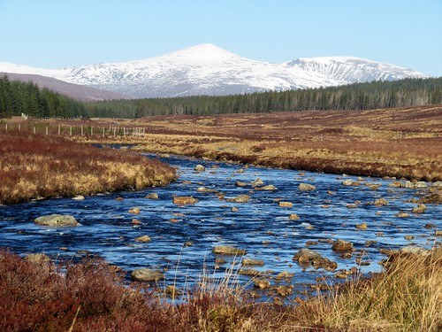
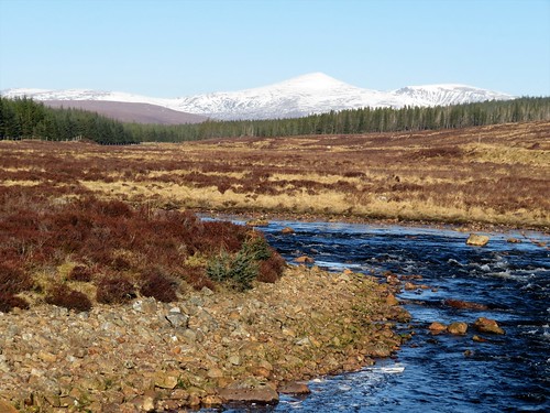
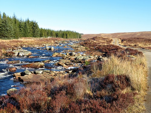
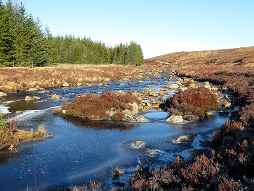
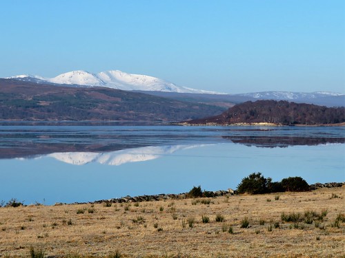
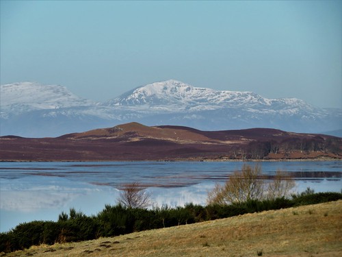
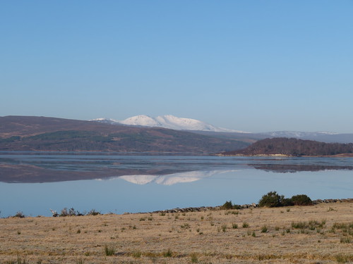
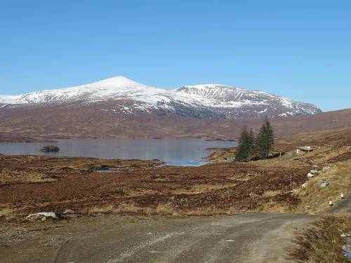
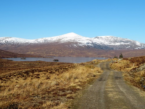
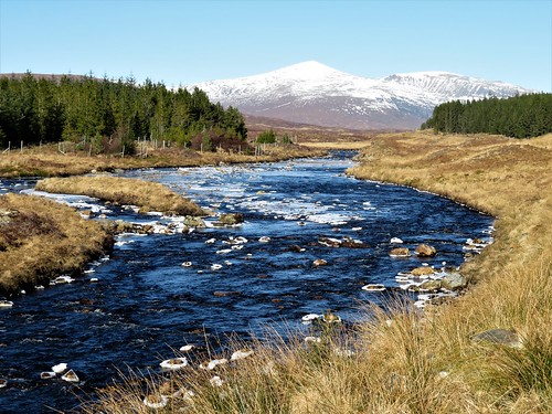
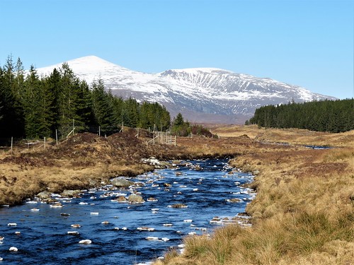
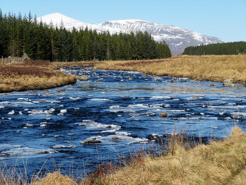
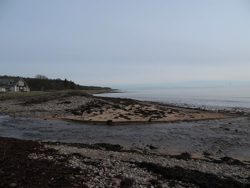
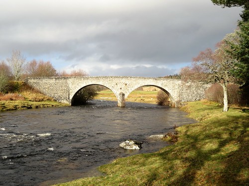
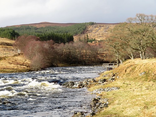
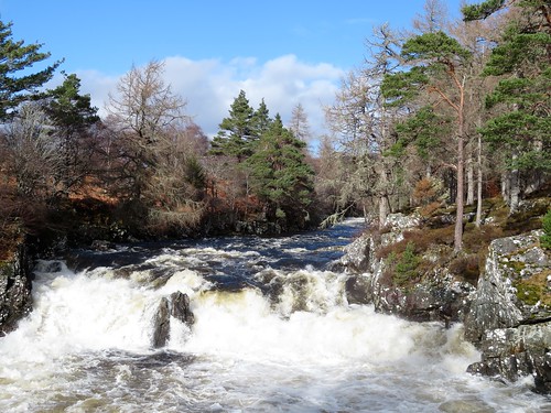
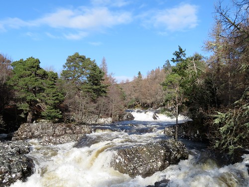
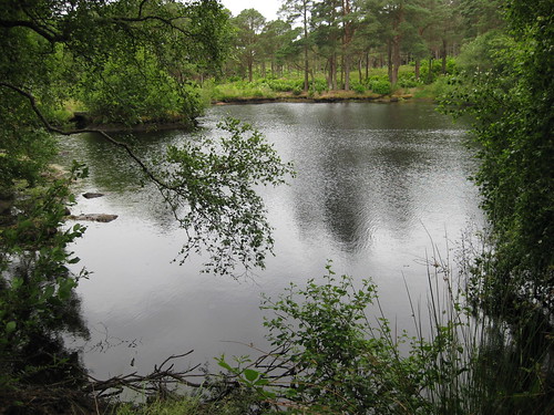
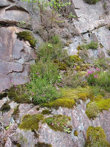
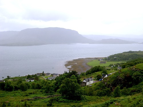
A peerless winter day in the north of Scotland, cold and clear. A cloudless blue sky, the lightest of winds. Snow on all the mountains, and none in the glens. Perfect weather for a walk up lonely Glen Fiag to even lonelier Loch Fiag, a remote mountain lake I’d often visited on wings of the imagination; one of those map walks you trace and hoard as soon as you spot it, saving it up like treasure for a beautiful day such as this. Ben Mor Assynt stood beyond Loch Shin, a white crumple of mountain reflected in the kingfisher-blue water. What a sight to turn your back on. But as soon as I’d rounded the corner of the broad stony track up the glen, there was the seductive shape of Ben Hee ahead to draw me on – a graceful pinnacle of dazzling white, with a humpy shoulder of rock half turned away on its flank as though repelling any thought of climbing. The River Fiag came rushing down between heather banks, a welter of indigo water among rocks, carrying miniature floes of ice that bumped and tussled over the rapids. Some of the rocks had grown lacy skirts of wafer-thin ice; others carried crests of old snow. I tracked the progress of a half-submerged floe through binoculars, mistaking its silvery-grey colour and spiny shape for the back and dorsal fin of some large fish. Loch Fiag has frustrated more than one attempt to stock it. Early in the 20th century one hopeful tenant put 10,000 rainbow trout in. They promptly escaped, fleeing downriver into Loch Shin where grateful anglers and herons had a field day. Glen Fiag lay silent. No birds stirred in the pine forests. The cottage of Fiag stood in ruins high on a bank, its lawn still green and grassy. Two sika deer were grazing there. Although 400 metres away, and with only a smidgeon of wind to carry my scent to them, they both sprang alert as soon as I appeared out of the trees, freezing stock still to watch the distant human figure pass by. The river was my constant companion today, a lively chatterbox, occasional veering away before hurrying back alongside. Another great mountain shape rose from behind the long brown shoulders of the glen’s moor tops – Beinn Leoid, a scoop of corries all dressed in snow. The track began a gentle climb, snaking over a mound to reveal long-imagined Loch Fiag. The lake lay steely grey today, entirely iced over save for a wriggle of royal blue where its water coursed out into the river. Beyond rose the pristine white slopes of Ben Hee. Fiag Lodge on the shore has been rebuilt from ruin in a futuristic style, like the hangout of a James Bond villain. Blofeld or no, what a truly sensational view the lucky occupants command. Start: Fiag Bridge, near Overscaig, Lairg, Sutherland IV27 4NY approx. (OS ref NC 468205) Getting there: Follow A838 Durness road from Lairg for 12 miles. 100m before Fiag Bridge, part at estate gate (‘Fiag’) on right. Room for 2 or 3 carefully parked cars – do not obstruct road or gate. Walk (10½ miles, easy, OS Explorer 440): Follow estate road for 5 miles north to Loch Fiag (455280). Return same way. Please respect privacy of Fiag Lodge. Lunch: Picnic at Loch Fiag. Accommodation: Oak Lodge B&B, Overscaig, near Lairg, Sutherland IV27 4NY (01549-431255, oaklodgebandb.co.uk) – lovely loch-side setting; excellent stopover.

Info: Inverness TIC (01463-252401); visitscotland.com; satmap.com

 Posted by at 01:29
Jan 132018


First published in: The Times Click here to view a map for this walk in a new window
picture picture picture picture picture picture picture picture picture picture picture picture picture picture picture picture
Facebook Link:

The two-car train rattled and squeaked its way out of Golspie, heading north-east to Brora along the outer edge of the Moray Firth. The woods and fields of the Sutherland coast flickered past the windows in bright morning sunshine, the winter sun casting a silver track across a sea as thick and slow-wrinkling as oil.

Setting off to walk back from Brora’s neat little station, we passed the village’s barrel-roofed ice house, and the tiny fishing pier laden with crabbing creels. Down on the shore we headed south-west along a pebbly strand that soon turned rocky, with slabs of pale ochre sandstone moulded into sculptural shapes by the sea. A pair of black-tailed godwits with bills like slender broadswords stalked the tideline, and a flight of oystercatchers took off in a scrabble of piping and wailing.

The pebbles of the shore were wonderfully coloured – orange and jet, speckly grey and jade green. Among them our boots scraped and tinkled, the noise drawing the round-eyed stares of a coven of grey seals. They lay as fat and glistening as slugs, their hind flippers twitched up like bluetit tails, waiting out the falling tide, each on its chosen slab of rock.

We crossed a skein of fords below Sputie, whose double waterfall cascaded down the cliff into a smoking pool. Beyond the fall the coast took a more westerly curve, opening up a handsome prospect of snowy mountains beyond the long east-trending arm of the lower Moray coast.

Above the shore stood a thick circle of stone walls, the remnant of the 2,000-year-old broch or Pictish tower known as Carn Liath, ‘the grey stone-heap’. Beyond again, the roofs and turrets of Dunrobin Castle rose above the treetops, a fairytale castle fit for a sleeping princess. This classic Scottish Baronial mansion was built for the 1st Duke of Sutherland. The Duke gained immortal notoriety for the harshness with which his orders of eviction were carried out on the hill herders and subsistence farmers of his enormous estates early in the 19th century.

Many of those clearance victims ended up on the coast at Golspie, forced to adopt new lives as fisherfolk. The 1st Duke stands in gigantic statue form at the summit of Ben Bhraggie behind the village, still dominant over the coasts and hills he once controlled with an iron hand.
Start: Brora railway station, KW98 6PY (OS ref 907041).

Getting there: Rail to Brora. Bus: service X99 (Inverness-Thurso). Road – Brora is on A9 between Golspie and Helmsdale.

Walk (8 miles, easy, OS Explorer 441): From Brora station, left along A9; 2nd left down Harbour Road. In 300m, bear left and follow ‘Back Shore & Beach Car Park’ to slipway down to shore (909035). Right along shore for 3¼ miles to Carn Liath broch (870014). Continue along shore for 1¼ miles. Opposite Dunrobin Castle walled garden, right inland (852006) up inclined road. Near top, opposite castle, left (850008, waymark post) on path through castle woodlands (occasional ‘village’ signs) for ¾ mile to cross Golspie Burn footbridge by Tower Lodge (839002). Left along shore path for 1 mile; 200m beyond pier, right inland up roadway (828995) to Ferry Road (825996). In 200m, left at B&B sign up laneway; right to Golspie station (824998). Return to Brora by train.

Conditions: Best done on a falling tide; some slippery rocks on shore

Lunch/Accommodation: Royal Marine Hotel, 7 Golf Road, Brora KW9 6QS (01408-621252; royalmarinebrora.com)

Info: Inverness TIC (01463-252401)
visitscotland.com; satmap.com; ramblers.org.uk

 Posted by at 01:00
Apr 222017


First published in: The Times Click here to view a map for this walk in a new window
picture picture picture picture picture picture picture picture picture picture picture picture picture
Facebook Link:

The old house of Rosehall drooped on its mossy terrace like a faded socialite the morning after the night before. Standing on the driveway looking out over the tussocky parkland and along the beautiful wild strath of the River Oykel, we pictured the grand heyday of Rosehall in the 1920s as the Highland love-nest of the Duke of Westminster and his glamorous paramour, Coco Chanel. The French couturière and designer, by the way, was no drooping lily. She walked, rode and fished as hard as anyone.

We strolled the carriage driveway under great beech, their trunks as pale and smooth as chalk. The brawling and rushing River Cassley, a tributary of the Oykel, winds through the park, and we walked upstream against its rain-swollen flow.

A crook of the river, barred across with enormous rocks and ledges, swung in a tight roaring curve below a little mossy graveyard spattered with snowdrops, its stone wall beautifully mended and maintained. Here landlord Neil Walter Graesser lies buried with his beloved fly rod. Nearby lies William Munro, the Rosehall gardener who died in 1821 at the not inconsiderable age of one hundred and four.

Above the graveyard a handy bench overlooked the thundering chaos of the River Cassley’s falls, the river foaming and jumping, vibrating the rocks under our boots, the water rearing back on itself in glass-grey surges around submerged snags in the riverbed.

We tore ourselves away at last, following a sedgy path that threaded the pines and birches of Rosehall Forest, rising steadily uphill in snaking curves between banks of ferns and mosses. These forest paths don’t look after themselves; it takes the sharp eyes and constant attention of many willing locals to keep them clear and passable.

Walkers are the beneficiaries. From the waymarked trail we looked out across the valley, over the roofs of Rosehall and away to a high ridge of hills over which peeped the snow-streaked peaks of the Sutherland mountains.

We descended towards the Achness Hotel, promising ourselves one of their piping hot bowls of cullen skink and a mighty session of music. It’s doubtful whether Coco and her Duke ever looked forward to their champagne and foie gras at Rosehall with keener relish.

Start: Rosehall Forest car park, near Lairg, IV27 4BD approx. (OS ref NC 479019)

Getting there: Car park is on A837 Rosehall-Ullapool road, ¼ of a mile before Achness Hotel, Rosehall

Walk (5 miles, easy, OS Explorer 440): From car park cross A837, through lodge gates opposite, down gorsy path to bridge and carriage drive (478015). Right; in 250m fork left past Rosehall House and follow drive. In 500m, at small stone bridge, fork sharp left (473020) and bear right along River Cassley to A837 bridge (472023). Cross road; down steps, cross footbridge and continue along river bank. In 600m, at graveyard (468028), pass entrance gate and follow wall, then path up to falls viewpoint of the River Cassley. Cross footbridge; on along river bank. In 200m, bear right at wooden gate (469029) with fence on right to road (470028). Right; in 50m, left through gate; path uphill (blue stripe posts). In 550m reach lookout bench and forest road (474030). Left; follow Deerpark & Wildwood Trail (yellow stripe posts). In ¾ of a mile, bear left up Achness Burn Trail (479030, brown stripes) for 250m to viewpoint (483031) and return to Deerpark & Wildwood Trail. Left to return to car park.

Lunch/Accommodation: Achness Hotel, Rosehall, Lairg IV27 4BD (01549-441239, achnesshotel.co.uk) – friendly, informal hotel with music sessions.

Info: scotland.forestry.gov.uk/visit/rosehall

visitscotland.com; satmap.com; ramblers.org.uk
The January Man – A Year of Walking Britain by Christopher Somerville (Doubleday, £14.99).

 Posted by at 01:21
Oct 222011
 

‘I award this walk,’ wrote Peter Barton in his wonderful guidebook Walking in Torridon, ‘the Golden Rose for its beauty, variability and grandeur.
First published in: The Times Click here to view a map for this walk in a new window
picture picture picture picture picture picture picture picture
Facebook Link:
I have walked widely in the Torridon region and have been to the summits of all its mountains, but I still rate this walk the loveliest of all.’

Powerful words. You could go a long way on them; all the way out to Torridon in westernmost Scotland in my case, spurred there by the promised magic of mountain, loch and wide empty country. I was lucky enough to be walking with Jim Sutherland of the Nine One Six mountain adventure company, who with his co-author Chris Lowe has updated what’s certainly the best guidebook a hillwalker in the sublime Torridon region could want. The weather might have been better (wind and rain – what’s new in west Scotland?), but at least it kept the damned midgies at bay, and it didn’t interfere with our enjoyment of the day at all.

Inveralligin village lies isolated on the north shore of Upper Loch Torridon, a sea loch under beautiful towering hills. The walk started with a mountain view of impossible majesty: the three summits of the Beinn Alligin horseshoe standing tall and formidable to the north, and across the racing whitecaps of the loch a dark uplift of ridges, corries and peaks centred on Beinn Damph. On a sunny day that prospect could easily have you trapped like a fly in a silken web; but not with half the North Sea trying to reach the Atlantic in the form of rain on a tree-shaking easterly.

We got down to the loch shore and were soon in the shelter of big beeches and limes, walking seaward with the rain at our backs. On a promontory beyond Torridon House stood a little church and a tall Celtic cross to the memory of a Victorian Laird of Torridon, Duncan Darroch. His tenants thought well of their landlord; after his death a hundred of them escorted his body over the mountains to its burial, a courtesy normally reserved for a clan chief. From the headland in the loch, more mountain heads revealed themselves: Sgurr Ruadh, the Red Peak; Beinn Liath Mhor, the Big Grey Mountain; Sgurr an Lochan Uaine, the Peak of the Green Lakelet.

Inveralligin lay beyond, a handful of white houses scattered along the shore, a tiny pier stacked with creels. There are communities even more remote than this along the coasts of western Scotland, but on this wild day we could have been well on the way to the end of the earth. A Golden Rose of a walk: Peter Barton had it just right.

Start & finish: Beinn Alligin car park, Torridon (OS ref NG 869576)

Getting there: Follow Inveralligin signs from Torridon village (on A896 between Kinlochewe and Shieldaig). Car park on left, 2½ miles west of Torridon.

Walk: (7½ miles, easy, OS Explorer 433): From car park, right along road, down to loch shore. Right along loch. In ¾ mile, fork left (870572, ‘Stables Cottage’); follow track past houses. Left in front of Stables Cottage (868573); over stile and on to pass track to church (863572). Continue to Inveralligin. Fork right by phone box; right along upper road (837579) to car park.

Refreshments: Torridon Stores Café (01445-791400) – try those amazing cakes!

Accommodation: Kinlochewe Hotel, by Achnasheen, IV22 2PA (01445-760253; www.kinlochewehotel.co.uk)

Nine One Six mountain guiding: 01520-755358; www.nineonesix.co.uk.

Walking In Torridon by Peter Barton, updated by Chris Lowe and Jim Sutherland (pub. Cicerone – www.cicerone.co.uk) – Walk EW7.

Info: www.visitscotland.com/surprise
www.ramblers.org.uk www.satmap.com
www.LogMyTrip.co.uk

 Posted by at 04:37
Oct 102009
 

First published in: The Times Click here to view a map for this walk in a new window
picture picture picture picture picture picture picture
Facebook Link:

The two-car train clacked and rattled its way up the Strath of Kildonan from the Sutherland coast, the landscape on either hand becoming increasingly high, wide and wild. Brown and grey bog-land swept away to hilly horizons on all sides. No green fields, no cosy farms, no settlements. Stepping down onto the platform at Forsinard Station, way out in the middle of these vast peatlands, I watched the train groan off towards Wick and felt a very long way from anywhere familiar.

The Flow Country occupies about a million acres of the northernmost Scottish mainland. This is the wettest and wildest landscape in Britain, lumpy with mountains and overspread with enormous swathes of sphagnum bog, apparently dead and bare, in fact seething with rare and extraordinary wildlife. The RSPB’s Forsinard Flows National Nature Reserve, based on its visitor centre in the former station buildings at Forsinard, preserves nearly 40,000 acres of this fragile and sombrely beautiful country from encroachments that threaten it in the shape of forests planted for investment purposes, agricultural ‘improvements’, wind-farms and other disturbances. It’s the pleasure of Colin Mair, the Forsinard reserve warden, to take visitors out walking across the reserve and give them a precious insight into an ecosystem whose treasures might escape the notice of uninstructed wanderers.

‘Greenshank, greylag goose, cuckoo …’ Colin recited the ‘recently spotted’ list as we tramped west across the squelchy sphagnum towards the dark peak of Ben Griam Beg, closely watched by three red deer hinds. ‘Golden plover, osprey, black-throated and red-throated diver – and golden eagle, though I haven’t seen that one myself.’ The divers are rarities nationally, but nothing unusual to birdwatchers in the Flows.

Meadow pipits flitted from sprig to sprig of the heather, common scoter (not so common, actually) and teal bobbed on the dark lakelets or ‘dubh lochans’ that formed a watery maze on the top of the rise. The dubh lochans get their name from their peat-shaded water, and peat is the keynote here – ten feet deep of unrotted vegetation that has been lying on the acid rock below ever since the last Ice Age. From the flat bog surface rose tuffets of emerald and ruby sphagnum. I bent to plunge my fingers deep into a pale grey velvet cushion of woolly fringe moss, and found myself looking at a tiny scarlet sundew, an insectivorous plant with a marbled fly trapped fast in its sticky hairs.

Up on the ridge we crept towards Gull Loch. There were no divers there today; just a solitary greenshank who got up and flew quickly away, his scarlet back a dazzling white spot against slate-grey clouds, his piercing ‘tew-tew-tew!’ coming back to us – a perfect expression of the wild spirit of this haunting and remarkable place.

Start & finish: Forsinard Flows National Nature Reserve Visitor Centre, Forsinard station, Sutherland KW13 6YT (OS ref NC 891425)

Getting there: Train (www.thetrainline.com) to Forsinard.

Road: A897 Helmsdale-Melvich road to Forsinard.

Walks:

  • Dubh Lochan Trail (1 mile, easy grade, leaflet guide): paved walkway to pools near Visitor Centre.

  • Forsinard Trail (4 miles, easy grade, leaflet guide): self-guided circular walk – fields, bog, pools, woods – riverbank, from car park on A897 (904485), 4 miles north of Forsinard.

  • Guided Walk (3–4 miles, moderate grade, Tuesdays and Thursdays, 1 May-31 August each year): walk with Reserve Warden to pools west of Visitor Centre. Wet and boggy – wear Wellingtons / waterproof shoes.

NB: online maps, more walks: www.christophersomerville.co.uk.

Lunch: Forsinard Hotel (01641-571221; www.theforsinard.co.uk)

Accommodation: Station Cottage, Forsinard (01641-571262;

http://www.scotland-index.co.uk/station_cottage/station_cottage.htm) – from &40 dble B&B

More information: Forsinard Flows NNR visitor centre (01641-571225; www.rspb.org.uk; www.nnr-scotland.org.uk); www.visitscotland.com/perfectwalks or ring 0845 22 55 121

 Posted by at 00:00