Search Results : warwickshire

Nov 272010
 

First published in: The Times Click here to view a map for this walk in a new window
picture picture picture picture picture picture picture
Facebook Link:
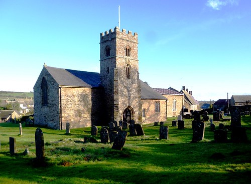
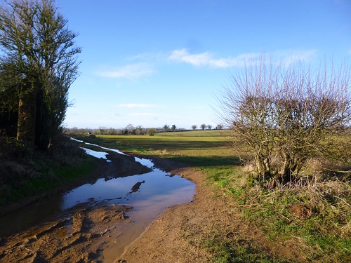
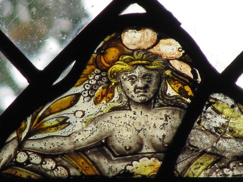
A cold breeze and a milky sky foretold winter, but the trees of Warwickshire still rustled autumn coats of gold and russet. St Lawrence’s Church stood squarely at the nape of Napton Hill, its iron-rich stonework smoothed and hollowed by eight centuries of wind and weather. Inside, a fragment of old stained glass showed a stern-faced and bare-breasted goddess crowned with a head-dress of harvest fruits. Along the lane to Napton windmill the hedges were bright with rose hips and haw berries. If autumn was being shoved to one side by winter, she was evidently still resisting pretty stoutly.

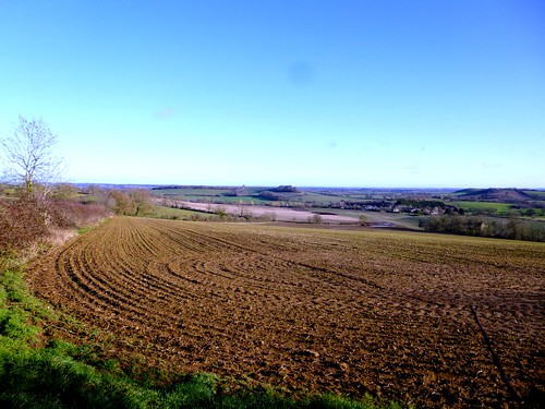
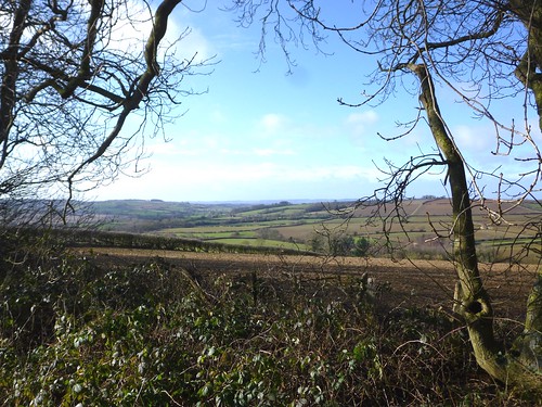
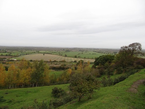
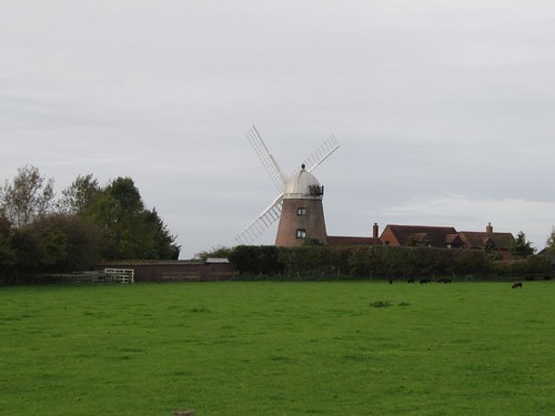
The old tower mill holds a vantage point right in the path of the wind on the escarpment edge. We looked out west across the tumbled ground and pools of the former village brickyard, away over many miles of Warwickshire. Then we dropped down the hill to follow the Oxford Canal to its confluence with the Grand Union on the northern outskirts of Napton

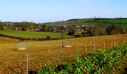
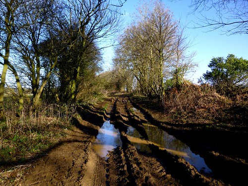
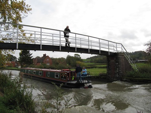
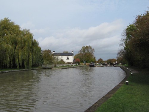
Canals shaped the Midlands early in the Industrial Revolution, snaking their way from town to town through the low-lying countryside. From the towpaths of the two man-made waterways the views were telescoped, an intimate prospect of grazing ponies, green and scarlet hedges and wind-ruffled water. Narrowboats with aspirational names – Free Spirit, Dancer to the Drum went puttering by. A tang of woodsmoke from the chimney of Kelly Lee, a waft of music from Saucy Lady.

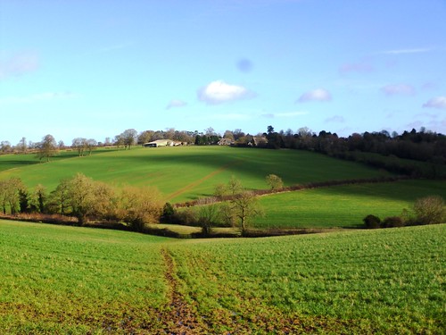
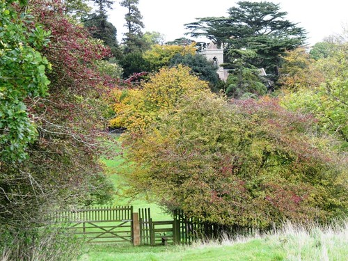
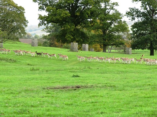
How many worlds one slips into and out of during a country walk! Up in the Shuckburgh Hills, eight centuries of residency by the Shuckburgh family have left their mark in a landscaped park full of fallow deer, islanded lakes and beautiful woods, a hall and church peeping among sheltering trees. One family’s gradually developed vision of heaven on earth, sublime at any season, today the park lay drenched in a spectrum of autumn colour from pale lemon to fiery crimson.

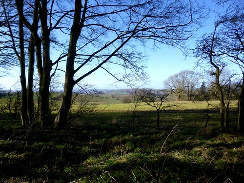
We followed the wood edge up to the peak of Beacon Hill, then descended the slope into the green vale once more. A streaky afternoon sky, the rackety shout of pheasants, and a brisk wind to nudge us back towards Napton-on-the-Hill, spread below church and windmill along its patchwork hillside.

Start & finish: St Lawrence’s Church, Napton-on-the-Hill CV47 8NP (OS ref SP 463613)

Getting there: Train (www.thetrainline.com; www.railcard.co.uk) to Leamington Spa (10 miles). Bus 214, 503. Road: ‘Napton village’ from A425 Leamington-Daventry; then ‘church only’.

Walk (7½ miles, moderate, OS Explorer 222): From church, track west to windmill; yellow arrows (YA) down scarp, across stile, bear left to road. Right across Oxford Canal; right to towpath, left for 1¼ miles to Napton Junction. Left up Grand Union Canal to Calcutt Locks. Right (YA) through hedge and gate; left up hedge to kissing gate; right for 1¼ miles, south of Calcutt House Farm, to Oxford Canal. Left to footbridge; right to Lower Shuckburgh church. Cross A425; YAs diagonally left uphill across fields, aiming SE between woods. Through gate by lake; at crest, right over stile (arrow); follow wood edge to Beacon Hill. Through gate; right along wood edge; YAs to road at Halls Barn Farm. Left through gate; right through double gates. Follow YAs due west, keeping same line, through fields for 1¼ miles, crossing 2 roads, to road in Napton. At foot of School Hill opposite, footpath (white notice) uphill; left at top to church.

Lunch: Napton Bridge Inn on canal (01926-812466), King’s Head on A425 (01926-812202), Crown Inn, Napton village green (01926-812484)

More info: Leamington Spa TIC (01926-742762); www.enjoywarwickshire.com;

www.visitcoventryandwarwickshire.co.uk

www.ramblers.org.uk; www.satmap.com

 Posted by at 00:00
May 292010
 

First published in: The Times Click here to view a map for this walk in a new window
picture picture picture picture picture picture picture
Facebook Link:

On the afternoon of 23 October 1642 two nervous and inexperienced armies, each of about 15,000 men, faced each other at Edgehill on the Warwickshire/Oxfordshire border. It was the first serious confrontation of the Civil War between Royalists and Parliamentarians. The Royalists occupied the great north-south ridge that dominates the Warwickshire plain where the Parliamentary army was deployed; but they forsook that advantage, descending the slope to fight it out in the fields below. By nightfall both sides were claiming victory in an inconclusive battle; a thousand men lay dead among the hedges and ditches, and three times that number were nursing wounds.

On a gale-tossed morning, looking out of my bedroom window in the Castle Inn on the edge of the escarpment, I was lord of a fifty-mile view, with the battlefield directly below. The fields where a thousand men died were striped with medieval ridge-and-furrow. The village of Radway, all golden stone and deep thatch, lay alongside the killing grounds. In the church I found the effigy of a Royalist officer in curly wig and knee-coat: Henry Kingsmill, Captain of Foot, ‘unhappily slaine by a Cannon Bullett.’ His grieving mother waited nearly 30 years after her son’s death, only erecting his memorial once the monarchy was firmly back on the throne and in popular favour.

I crossed the ridge-and-furrow and struggled back up the escarpment by way of steep King John’s Lane (what was that wicked monarch doing here?). Two long-distance paths, Centenary Way and Macmillan Way, run the length of Edgehill ridge and provide a wonderful grandstand view over the plain to the far hills. I walked for miles, pushing into the wind and savouring the prospect. ‘Mornin’!’ hailed an Ancient Mariner, stumping by on a stick. ‘Bit breezy!’

At last the path edged away from the ridge. I crossed the county boundary, turning my back on the windy heights of Warwickshire and descending into the calm of a hidden cleft in the Oxfordshire wolds. In a sunken lane going down to Hornton I met two shifty gents and their lurchers. ‘Hungry, mate? You’re only five minutes from the Dun Cow.’ Ha, ha, very funny – that delightful inn doesn’t open on a weekday lunchtime. But the beauties of Hornton’s thatched houses, their rich gold stone and air of deep-sunk contentment seemed refreshment enough on this vigorous day.

There was laughter in the Rose & Crown along the way in Ratley, thrush song in the yew outside the square-built church. Some kind of spring-time God must be in his heaven, I thought, as I stole a pinch of sage from a wayside bush and made up the fields towards Edgehill.


Start & finish: Castle Inn, Edgehill, Banbury, Oxon OX15 6DJ (OS ref SP 374474)

Getting there: Bus (www.johnsonscoaches.co.uk) service 269 Banbury-Stratford. Road: M40 Jct 12; B4451 to Gaydon; B4100 towards Warmington; right to Edgehill.


Walk (10 miles, moderate grade, OS Explorer 206): Go down footpath by inn (‘Battlefields Trail’/BT). In 30 yards, right (blue arrow/BA) down woodland path. Right at bottom (BA). In ¼ mile, left (377478; kissing gate, yellow arrow/YA) down field to Radway. Left along road. Opposite church, left down Westend. At Church Farm, right fork of footpath past right end of cottage (‘King John’s Lane’ fingerpost). On for ¼ mile; left (366475) up King John’s Lane.

At top of ridge, forward (‘Centenary Way/CW, Macmillan Way/MW’). In ½ mile cross farm lane at Edgehill Farm. In ⅔ mile, left up A422 at Sun Rising (very dangerous blind bend! Take care!); right along CW/MW. In ⅔ mile CW forks right (356450), but follow MW ahead, down to lane. Left (354446; MW) to cross road. Continue with fence and hedge on your right (MW) down into valley for 1 mile to pass barn (371440). At end of 2nd large field past barn, where MW passes through gate as broad track, leave MW, turning left uphill to cross stile on skyline (376435). Diagonally left across fields (YA; ‘D’Arcy Dalton Way’/DDW). At road, left to cross A422; right along its verge; in 300 yards, left (382439; DDW) for 1 mile along bridleway past Hornton Grounds into Hornton. (Dun Cow PH to your left – see note below on opening times!).

Forward past school; follow Millers Lane uphill to cross road (392455). Bridleway (BA, fingerposts) for 1 ¼ miles to Ratley (NB – very muddy around Poplars Farm – 390461!). In Ratley, left down Featherbed Lane past Rose & Crown; left past church; left opposite Old Post Office, past Manor Farm (stone stile); on across fields (YAs). At top of rise, over stile (379471); right (BT) to road. Right for 50 yards; left (YA, BT) to Castle Inn.

NB – Online map, more walks: www.christophersomerville.co.uk

Note: some very muddy parts – boots/gaiters advised!

Lunch: Dun Cow, Hornton (01295-670524; open every evening, but lunchtimes Sat, Sun only; open weekday lunchtimes by prior arrangement; please phone); Rose & Crown, Ratley (01295-678148; www.roseandcrownratley.co.uk)

More info: Banbury TIC (01295-753752);

www.visitcoventryandwarwickshire.co.uk; www.ramblers.org.uk


 Posted by at 00:00

Ships of Heaven – talks and events coming up round the country


2020 Dates:

23 January, 6.45 pm – Henleaze Library, 30 Northumbria Drive, Bristol BS9 4HP

30 January, 1pm – Stanfords Travel Writers Festival, Olympia, Hammersmith Rd, Hammersmith, London W14 8UX – www.stanfords.co.uk/Destinations-Show-Travel-Writers-Festival

17 March, 7.00pm – Southwark Cathedral, London – cathedral.southwark.anglican.org

28 March, 2pm – Balliol Hall, Church Rd, West Huntspill, Highbridge, Somerset TA9 3RN

10 May, 11am – Chiddingstone Castle Literary Festival, Kent – chiddingstonecastle.org.uk

12 May, 4pm – Stratford-on-Avon Literary Festival, Warwickshire – stratfordliteraryfestival.co.uk

29 May-6 June (date TBC) – Derby Book Festival – derbybookfestival.co.uk

25 June – Reform Club, Pall Mall, London

5 September, 3pm – Friends Day, Salisbury Cathedral – salisburycathedralfriends.co.uk

 Posted by at 08:15
Mar 012014
 

A beautiful winter morning, piercingly cold, under a blue porcelain sky spread across the gently undulating landscape where northernmost Oxfordshire runs hand-in-hand with Warwickshire. First published in: The Times Click here to view a map for this walk in a new window
picture picture picture picture picture picture picture picture picture picture picture picture picture picture picture picture
Facebook Link:
This is ironstone country, reflected in the burnt orange hue of the cottage walls in Sibford Gower. As we left the village, the low wintry sun washed the fields. Every leafless tree stood footed in a giant shadow. It was a morning to savour, and we felt more than ready for it – incessant rainstorms had been drowning the country for the past month, and another was forecast for this afternoon.

Green ranks of winter wheat squelched underfoot, and a stodge of puddles flanked every stile and gateway. We strode out with all the energy that a brisk wind lends, across stubble gleaming with sunlight in gold and cream. A flock of sheep lay at ease in a turnip field, slicing and chewing the sweet white flesh of the roots with their strong yellow teeth. Down in Epwell we leaned on the churchyard gate and admired the scene, everyone’s dream of an English village setting, the mellow stone church with centrally placed tower leading the eye along to a row of sunlit cottages.

Little hard green crab apples spattered the hedged path that took us on from Epwell over the fields to find the rutted thoroughfare of Beggar’s Lane. This ancient trackway runs under many names – Ditchedge Lane and Traitor’s Ford Lane are two more – connecting with other old green roads oriented from north-east to south-west, reputedly linking York and the west country at its extremities. Hereabouts it runs as a snaking lane 18 yards broad between hedges of oak and sycamore, devoid of leaves in this cold season, but with tiny scarlet buds on every twig as a promise of spring.

A horse came dashing by with a clatter of hooves and a splatter of divots, its rider’s crab-claw profile reddened with wind and weather. ‘Hope you don’t mind us cantering past,’ he called, ‘only it’s nice to give him practice at not shying at everyone he meets!’ We didn’t mind at all – it seemed a timeless image, the muddy horse and rider pelting along the ancient greenway, a moment snatched from any winter’s day in the past five thousand years.
Start: Wykham Arms, Sibford Gower, Banbury, Oxon, OX15 5RX (OS ref SP 352378). Park at pub – please give them your custom.

Getting there: Bus – Service 55A (www.stagecoachbus.com/), Stratford-upon-Avon to Chipping Norton
Road – Sibford Gower is signposted from B4035 between Lower Brailes and Swalcliffe

Walk (6 miles, easy, OS Explorer 191): From Sibford Gower follow road to Burdrop. Left (‘Swalcliffe’); in 100m, take footpath by Cubbs Cottage (358379); follow well-marked D’Arcy Dalton Way (DDW) north via B4035 for 1½ miles to road in Epwell (354403). Left past Chandlers Arms PH; on left bend, right (DDW) to road by church (352405). Left round right bend; left (‘Macmillan Way’/MW; fingerpost) up path. Through gate (MW); right to another gate (350404); don’t go through, but bear left up field edge to road (348401). Right for 50m; left (‘Beggar’s Lane’) across field, aiming for stile to right of communications tower (345401). Left (MW) along Beggar’s Lane to B4035 (344394). Right for 250m; left (MW) along Ditchedge Lane for 1¼ miles. Where lane begins to descend towards Traitor’s Ford, turn left (339373, yellow-top post, blue arrow) across field. 50m beyond Haynes’s Barn, left through hedge (342372, fingerpost); follow path (yellow arrows/YA) down to cross stream (345376), up far side to top of field (349378). Bear left along field edge; in 100m, right over stile (YA) into lane. Left; immediately right through gateway; follow lane into Sibford Gower.

Lunch: Wykham Arms, Sibford Gower (01295-788808; wykhamarms.co.uk) – well-kept, friendly pub.

Accommodation: Gate Hangs High Inn, Hook Norton (01608-737387; gatehangshigh.co.uk)

Information: Banbury TIC (01295-753752; visitnorthoxfordshire.com)
Crickhowell Walking Festival, Wales, 1-9 March: www.crickhowellfestival.com

www.ramblers.org.uk www.satmap.com www.LogMyTrip.co.uk visitengland.com

 Posted by at 01:11