Dec 202008
 

It was a beautiful winter morning, shortly before Christmas – one of those crisp, smoky mornings with ice skinning the puddles and a sky of unbroken blue over the leafless woods.

Nature calls you imperiously out of doors, then smacks you in the face when it has got you there. Setting off from The Swan Inn in the West Berkshire hamlet of Lower Green, eyes running with chilly tears, breath pluming out like a leaky locomotive, I gasped with cold. Five days ago I had been basking in 35°C heat in tropical north Australia, and this thermometer plunge into the minus zone was a shock to the system.

Out in the fields rooks strutted the stubble rows, their fat feathery thighs making them roll like drunken sailors. My boots cracked milky panes of ice in the ruts; brambles hung whitened and stiff in the hedges, each spiny leaf tipped with a droplet of half-melted frost. All the pleasures of walking in the English countryside in winter suddenly came flooding in on me. After weeks of energy-sapping heat on baking Queensland beaches I welcomed the rough embrace of winter stinging my cheeks, a brisk exhortation to stride out and get the blood coursing round the body.

Up the steep breast of Inkpen Hill I slogged, puffing out steam, stripping off scarf and then woolly hat as the interior radiators were turned on full by the hard exercise. Up at the top there was time to pause, pour a cup of coffee from the flask and take in the quite stupendous view. I gazed north, 20 or 30 miles across the plains of Berkshire and Wiltshire towards the White Horse Downs and the distant Cotswolds. The windows of country houses flashed among spinneys and copses that in the full leaf of summer would shield them from sight. Sheep moved slowly along the crest of the down, their fleeces turned to gold in the sunlight.

The black T-bar of sinister Combe Gibbet, by contrast, stood stark on the humped back of a Neolithic burial mound. The original hanging scaffold, set here on the skyline so that everyone for miles around would see it, was used only once. In 1676 the bodies of George Broomham of Combe and his lover, Dorothy Newman of Inkpen, were suspended from each cross-piece and left to rot as a grim warning, after the pair had been hanged for murdering Broomham's wife Martha and his son, Robert. It was Mad Thomas, a barefoot village idiot, who blurted out that he'd seen the victims being drowned in a pond. They had stumbled by chance across the lovers, in flagrante delicto, on the down.

Beyond Combe Gibbet rose the green inverted bowl of Walbury Hill, bisected by the ancient trackway I was following. The works of our distant ancestors litter the long ridge of the downs hereabouts: burial mounds, ditches, rutted tracks and the high-piled ramparts of Walbury Camp. It is easy to see why Iron Age men fortified this hilltop – at 974ft above sea level, Walbury is the highest chalk hill in Britain. Anyone commanding this site would be able to see strangers, friendly or otherwise, approaching from any direction in plenty of time to prepare an appropriate reception.

From the old hilltop stronghold I dropped down into the sheltered valley where Combe hamlet sits. In the south wall of the flint-built Church of St Swithun, shadowed by yews, I found a tiny stone head carved by some humorous-minded medieval mason, an imp-like homunculid with crazed feline eyes and the cheekiest of smiles. The narrow interior with its fine Victorian glass and elaborate Georgian graveslabs of black marble breathed peace and stability, a fixed point in a whirling world.

Up on the back of the downs once more, I faced into the wind and forged northwards. Pheasants exploded out of the hedge roots, and meadow pipits flew swooping and squeaking across the track. Back at the crest of Inkpen Hill I took a deep breath and went half-running down the slope, through a tunnel of pale elder suckers and back into Lower Green, heading for the door of the The Swan Inn.

There are certain pubs that you'd cheerfully take root in. The Swan is one of them: a firelit winter pub par excellence that brews its own bitter and serves its own organic beef. Cheerful barman Tomas, a Prague boy very much at home in the Berkshire countryside, pulled me a pint of the sort Australians will never understand. I sat by the log fire, feet well out in front of me, fingers a-tingle as they thawed; I felt my cheeks reddening and my grin widening. It was good to be home.


 Posted by at 00:00
Dec 142008
 

A blowy Sunday morning in westernmost Pembrokeshire after a week of grey, horizontal weather – and boy, were we keen to see the sun. When the clouds began to shred away off the moor tops and the hint of a tint of blue shone through, we were out of our holiday cottage and down in St David's before you could blink.

St David's is one of those neat little towns you don't want to leave in a hurry. We slipped into the Cathedral between Holy Communion and Parish Eucharist to admire the beautiful Norman pillars of purple slate, the chisel marks of the masons still plain beneath the patina of 800 years' smoothing by hands, backs and shoulders. I ducked into the choir to indulge my passion for medieval misericord carvings. There were some beauties, including two very fine leafy Green Men, a curly dragon, and a crafty fox in a clerical cowl preaching to some trusting inhabitants of the farmyard. The light was low and muted in the church, built deep in a hollow so that – legend says – marauding Vikings might pass by without suspecting it was there.

We caught the little Celtic Coaster bus and went rattling down the twisting, high-banked lane to St Justinian's. From the cliff we gazed across the mile-wide strip of Ramsey Sound to the twin peaks of Ramsey Island RSPB Reserve. The solitary farmhouse stood above the landing slip, a tiny gleaming cube of white. Here was a pure drop of nostalgia for me. Twenty years ago I had waited on this cliff above the cream-and-crimson corrugated tin shed of the lifeboat, looking out to the ferocious tide-rips of Ramsey Sound through which a rubber boat was bouncing and smacking its way towards me. It had been a bumpy and spray-drenched old journey to the island, and a strangely enthusiastic welcome on arrival. I soon found out why – I had arrived just in time for the annual sheep shearing, and Ramsey was short-staffed.

What a hell of a weekend that turned out to be. Ramsey back then had been privately owned, under covenant of the National Trust, and its flock of sheep had been let run completely wild. Six of us, "assisted" by a half-trained pup called Spot, set out to gather them off the hills and slippery cliffs of the two-mile-long island. The tough guys sheared them in the stuffy shed, between glugs of beer and puffs of tobacco. I was appointed tallyman/door wallah, and scored a mark in purple wax crayon on the shed wall for each bucking, tittuping beast that sprang past me from the hands of the shearers. By the end of the day there were 198 strokes on the shed wall. I have never been sworn and shouted at so much, laughed so hard or ended the day in such a drunken daze of exhaustion and triumph. Sheer anarchic magic.

Holidaymakers who had booked a boat trip round the island were waiting at the lifeboat shed today, staring across the white horses of Ramsey Sound and cracking nervous jokes about losing their breakfast. Jane and I, turning along the cliff path where the wind was shaking the clumps of thrift and toadflax, felt glad to be keeping to terra firma. Sea wind is a constant here on the coast of Pembrokeshire, streaming the hedges of sea buckthorn inland and sculpting the gorse sprigs into rounded yellow clubs. The sharply canted cliffs fell away to the waves in weather-smoothed flanks of green and mauve, and a sparrowhawk hung in the wind a few feet above our craning faces.

Looking ahead into the long curve of Whitesands Bay, we saw the sands between the rocky headlands of Point St John and St David's Head covered in short figures, most of them in suits of black, running, screaming and leaping. It looked like a painting by LS Lowry with added glee. Down on the beach we discovered it was Young Life-Savers Day. In spite of the barking instructors and their gung-ho exhortations, most of the wet-suited youngsters looked as though what they were out for was a good splash in the pounding surf.

Among the dunes lay a humpy green mound, all that remains of the little Chapel of St Patrick where newly landed seafarers of the Dark Ages would kneel and give thanks for deliverance from the dangers of the twin headlands. Others, outward bound, would pray before embarkation for the saint's protection amid the hazards of the sea. St Patrick was felt likely to lend a sympathetic ear, since stories said that it was from Whitesands Bay that he himself had set sail in AD432 to bring the Word across the sea to the heathen Irish.

Did the great patron saints of Ireland and Wales, Patrick and David, ever meet each other on Ramsey Island, as other tales tell? Certainly the rugged island had its own macho 5th-century saint in the person of Justinian, a nobly-born Breton both misogynistic and imperious, who expelled two holy women from Ramsey so that he could live there, and so infuriated his own monks that they cut his head off. Nothing daunted, Justinian marched across the Sound to his burial place on the mainland with his head under his arm. They seem to have made them tough back then.

Out on the windy extremity of St David's Head we passed through the double wall of Clawdd-y-Milwyr, the Warrior's Dyke, built 15 feet high by the Iron Age farmers who lived out here behind this formidable barrier. Who was it that they feared so greatly? Now their great wall lies less than man height, scattered and tumbled among blue feathery buttons of scabious and white bells of sea campion. Nearby along the cliff path loomed Arthur's Quoit, a giant stone slab propped up by a slender upright. Our ancestors raised it as the capstone of a kingly tomb nearly 6,000 years ago. Or was it mighty Arthur, hero-giant of Welsh folklore, who hurled it here from Moelfre Hill? The head urges one story, the heart another, when one walks these rocky moors and cliffs so drenched in the mythological past.

The clink of rock-climbing harness recalled us to the practical present as a breath of warm sunlight stole along the coast. Climbers were inching their way down to the rocks of Ogof Coetan, the Cave of the Quoit, where the waves leapt fitfully and tongues of foam came licking up at the adventurers. Jane and I moved on along the path, threading our way through beautiful coastal heath of gorse and heather whose topmost sprigs held black-capped and russet-breasted stonechats. Time for a little climbing on our own account.

By tip of boot and finger we scrambled up the 600ft volcanic tor of Carn Llidi. Little children in shorts and trainers were prancing around the summit like mountain goats. Down below lay Whitesands Bay, a crescent of sand where lines of surf were creaming. Out at sea, gathering clouds hid the horizon. Here on Carn Llidi, Patrick the Welsh-born shepherd once stood, gazing west to where the pale blue peaks of Wicklow pierced the skyline a hundred miles off. There was no chance of seeing them this day. But the thought of them made me smile as we picked our way back down to the seashore once more.

Stepping out

Maps
OS 1:25,000 Explorer OL35, 1:50,000 Landranger 157

Travel
By train (www.thetrainline.com) or coach (www.nationalexpress.com) to Haverfordwest; bus 411 (www.pembrokeshire.gov.uk/coastbus) to St David's. Celtic Coaster bus (service 403, operates March-September) between St David's, St Justinian's and Whitesands Bay.

By car
M4, A48, A40 to Haverfordwest; A487 to St David's; minor road signposted to St Justinian's.

Walk directions
From St Justinian's car park (OS ref SM724252), walk down lane towards sea and turn right along Pembrokeshire Coast Path National Trail (signed with fingerposts and acorn symbols) for four miles via Whitesands Bay (734272), St David's Head (722279) and Arthur's Quoit (725281) to reach a short fingerpost (736287 – acorn symbols and ''YHA'') just before a stonewalled enclosure. Follow YHA up to right; in 100 yards bear left to follow broad grass track uphill with twin hump of Carn Llidi on your right. At saddle (739283 approx.), right along track to scramble up to summit of Carn Llidi (738280). Continue across two crests, descending by rock scramble to lower of two concrete wartime emplacements below Carn Llidi Bychan (735279). Turn left down path past Upper Porthmawr farm (737276) to reach Whitesands Bay car park (734272).

Length
5½ miles (7½ to return to St Justinian's via coast path)

Conditions
Some cliff-top stretches are narrow, other parts rocky underfoot. Climb to top of Carn Llidi involves a little scrambling. Wear walking trainers/boots.

Refreshments
Café and public loos at Whitesands Bay; Old Cross Hotel, St David's (01437 720394, www.oldcrosshotel.co.uk)

Accommodation
Old Cross Hotel, St David's (see above); www.welsh-cottages.co.uk for holiday lets.

Information
Tourist Information Centre, The Grove, St David's (01437 720392, www.visitpembrokeshire.com)


 Posted by at 00:00
Nov 012008
 

If you're looking for a bland, impersonal, run-of-the-mill place to base yourself for a walk around the Stiperstones, avoid the Bog Centre like the plague.

Its dark stone building – once a back-country schoolroom for the children of Victorian lead miners, now a visitor centre run by mustard-keen local volunteers – can look bleakly forbidding, especially on a murky afternoon of drifting hill mist and low cloud the colour of bruises. But stepping inside, out of the chill and damp, I found a hive of gossip and kitchen clatter, positively buzzing with warmth and character. Not only that, but some of Shropshire's finest home-baked cakes, quite irresistible to the hungry walker, and the greedy one too. I devoured one of each, and I hadn't even set out yet. They were just as good as those I'd tasted on my last visit – maybe even better. Devil's Chocolate, Wild Edric's Tart, Bog Cake: off-kilter names, with a whiff of puckish humour very typical of this out-of-the-way area where demons are said to dance on the hilltops and warlocks to walk abroad when the mist is down on the stones.

It was a hard job to separate myself from the cake stall and the giant teapot, but I shook the last crumbs of Bog Cake manfully from my beard and got myself out into the open air. The sun looked weakly through the fog, a pale presence more hinted at than seen. A pearly coat of mist lay on the heather of the Stiperstones ridge, where gorse sprigs glistened with trembling spider webs. Walking up the stony path, I stared ahead and upwards for the first glimpse of the Stiperstones themselves, and tried to remember what I knew of these fantastically shaped tors of quartzite – Cranberry Rock, Manstone Rock, the Devil's Chair, Scattered Rock, Shepherd's Rock – that rise from the apex of their ridge like a line of cartoon monster heads.

Giant pressures brought about by volcanic upheavals some 500 million years ago formed the shining white quartzite of the Stiperstones, long weathered to a cloudy, lichen-blotched grey. The frosts of aeons shattered and sculpted them into pinnacles, towers and canted blocks. The metallic content of the rocks attracts lightning strikes; the elevation of the ridge lures clouds and wild weather. Small wonder that superstitious locals, their skyline view dominated by the storm-bound stones, invested them with demonic force.

The toothed silhouette of Cranberry Rock loomed out of the mist, and I stopped in its shelter to wipe water droplets off my spectacles. Near here, Slashrags the tailor once outwitted the Devil, "a big Boogebo with a strong sulphurious smell", by bringing Mr Brewster the parson to their midnight rendezvous. Just along the ridge, I came to Manstone Rock, rising from the dark peat to a funnel-shaped top – a chimney down to hell. Here, each winter solstice night, the demon rout of Wild Edric the Saxon commences its mad procession among the Stiperstones; and from this spot at midnight one can see the corpse of Lady Godiva riding her spirit horse – eternal punishment for choosing to go hunting when she should have been at church. Wild stories all; but the wildest are reserved for the Devil's Chair, the largest and weirdest of the stones, with its "window" through which only the bravest will creep and its seat in which only the reckless will dare to sit.

"For miles around it was feared," wrote Shropshire novelist Mary Webb in The Golden Arrow. "It drew the thunder, people said. Storms broke round it suddenly out of a clear sky. No one cared to cross the range near it after dark… Whenever rain or driving sleet made a grey shechinah [resting place] there, people said, 'There's harm brewing. He's in his chair'. They simply felt it, as sheep feel the coming of snow."

It was the devil who made the chair, the stories say, by letting slip an apronful of stones as he flew overhead. He might have tidied them up, at least: it's a slippy, rubbly ankle-breaker of a path that runs on along the ridge. As I passed Scattered Rock, the hill wind began to shred the mist; and by the time I had reached the cairn near Shepherd's Rock and started down into the valley, the Stiperstones were standing outlined against a cold afternoon sky of the palest blue.

Squeezed into extravagant snake bends between the bulging flanks of Perkins Beach and Green Hill, the old miners' path fell away 600ft to reach Stiperstones village far below. Through the steamy windows of the pub I glimpsed other walkers yarning over their pies and pints. But that surfeit of Bog Cake still needed some working off. I turned my back on temptation and stepped out for the Bog Centre along a high stony laneway below the ridge, where the craggy heads of the Stiperstones stood magnificently against the rain-washed sky.

Christopher Somerville is the author of "Britain and Ireland's Best Wild Places: 500 Ways to Discover the Wild" (Allen Lane)

Walk FILE

Maps: OS 1:25,000 Explorer 216; 1:50,000 Landranger 137, 126

Length: 5 miles

Start and finish: The Bog Centre, Stiperstones (www.bogcentre.co.uk)

In brief: Shropshire Way from road (OS ref 362976) past Cranberry Rock (365981), Manstone Rock (367986), Devil's Chair (368991). From cairn just before Shepherd's Rock (374000), steep descent to Stiperstones village (363004) and Stiperstones Inn. Return to Bog Centre via 361002, 359999, 361996 and lane parallel to the Stiperstones.

Eat/drink: The Bog Centre or Stiperstones Inn (www.stiperstonesinn.co.uk)

Travel: Train to Church Stretton (www.thetrainline.com).

Car: A488 north from Bishop's Castle or south from Shrewsbury; signs to Shelve, then Bog Centre.


 Posted by at 00:00
Oct 142008
 

Everyone is walking these days, all over the world. Travel has never been easier; guided walks, and the companies that offer them, have never been so thick on the ground. Who doesn’t know someone who’s hiked to Machu Picchu, or climbed Mount Kilimanjaro, or gone trekking in the Himalayas? And yet some of the best walking in the world lies right on our doorstep in these fortunate isles where fantastically rich and varied geology, history, wildlife and humanity jostle for a walker’s attention at every step.

Right now is a brilliant time to be slipping on the trail sandals or lacing up the hiking boots. In Britain the colours are on the turn, the hedges are full of blackberries at their sweetest, and after the miserable summer we’ve endured the Clerk of the Weather seems set to compensate us with a fine Indian summer of an autumn. Further and higher afield the snows have yet to hit the mountains, and the big chill is still a month or two away. School children are back at the chalk-face, too, so good deals are on the table, the cliffs and beaches are emptying and the upland tracks are losing their hiking crowds.

It doesn’t matter where you are in the world: walking is the way to go. It’s clean and green, of course (or it should be, if you plan your own trip or go with a reputable company such as those recommended below). But more than that – it’s the best, in fact the only way to get at the heart and soul of a landscape. Fly, sail or drive it, train it or bus it or bike it: you won’t touch it as you could and should. On foot you talk to people at human pace in their own valley or on their native hillside. You not only see the wayside flower, the bird over the crags, the ruin on the promontory; you stop and look, you turn aside and scramble up to explore, to savour and to understand. In a world turning more and more virtual, homogenized and sanitized, walking is the true and only way to catch the unbeatable magic of strong and sometimes scary challenge, of meeting and communicating with real people in their everyday setting, of intense experience pouring in through all five senses at full stretch.

Here is my personal selection of 50 of the world’s great walks. Some are short, some are long. There are easy strolls and demanding hikes; walks way out in the wide blue yonder, and walks very near to home.

Enjoy them to the hilt!


1. England

Landslips have made Lyme Regis’s Undercliff uninhabitable – to humans. The narrow path threads England’s own untouched ‘rainforest’ landscape.

  • Lyme Regis to Axbridge, Dorset/Devon border
  • 3 hours
  • Narrow woodland path – no escape routes
  • Easy grade
  • Nightingales, spring flowers, solitude, spectacular landslips
  • www.jurassiccoast.com ; OS Explorer 116


2. England

Follow the Peter Scott Walk for 11 miles round the margins of The Wash estuary to King’s Lynn, savouring the remote marsh landscape.

  • Sutton Bridge, Lincolnshire/Norfolk border
  • 4-5 hours
  • Flat sea wall
  • Easy grade
  • Huge skies, vast numbers of geese in winter
  • King’s Lynn TIC (01553-763044; www.visitwestnorfolk.com); OS Explorer 249


3. England

In Upper Teesdale a delicate post-Ice Age flora is miraculously preserved along the Pennine Way beside the brawling River Tees.


4. England

A strenuous walk in wild Eskdale, least frequented corner of Lakeland, climbing to a stunning 360º prospect from Bow Fell.

  • Brotherilkeld Farm, Eskdale, Cumbria
  • 6-7 hours
  • Rough, stony and steep
  • Hard grade
  • Rock, water, wind, sky
  • Bk 4, A Pictorial Guide to the Lakeland Fells by A. Wainwright (Frances Lincoln, www.franceslincoln.com); OS Explorer OL6


5. North Wales

Around the tip of the Llŷn Peninsula. St Mary’s holy well in the cliffs overlooks turbulent Bardsey Sound and Bardsey island.

  • Aberdaron, Gwynedd
  • 6 hours
  • Cliff and moor paths
  • Grade: Moderate grade
  • Spectacular cliffs, St Mary’s Well (OS ref 138252), views of Bardsey
  • www.edgeofwaleswalk.co.uk; OS Explorer 253


6. Scotland

In the tumbled back country of Inverpolly, a boggy moor path and a scramble up the leonine mountain of Suilven.


7. Shetland

The most northerly place in Britain. Wind-blown, lonely and breathtaking.

  • Burrafirth, Isle of Unst
  • 3 hours
  • Hill track, exposed moorland
  • Moderate grade
  • Nesting (NB – and aggressive!) great skuas, puffins, wild coast scenery, Britain’s Most Northerly Point
  • www.unst.org ; OS Explorer 470


8. Northern Ireland

To the 573 m. summit of Slieve Gullion, County Armagh’s beautiful gorse-yellow mountain.


9. Republic of Ireland

A challenging 30-mile-in-a-day hike through the uninhabited mountain range of Nephin Beg, along the waymarked Bangor Trail.


10. Republic of Ireland

A Dingle Peninsula delight – stroll down the 8-mile beach of the Maharees sandspit beside Brandon Bay, with Brandon Mountain as a backdrop.

  • Fahamore, near Castlegregory, Co. Kerry
  • 3 hours
  • Firm sandy beach
  • Easy grade
  • Superb sandy beach walking; views of Mount Brandon
  • http://en.wikipedia.org/wiki/Maharees; OSI Discovery 70, 71


11. Channel Islands

Strange rock shapes, pinnacle and spires emerge at low tide off Jersey. Walk out to 18th-century Seymour Tower – but watch the tides!


12. France

Poignant walks along the front lines of the Battle of the Somme. How and where (but not why) 300,000 men lost their lives.

  • Near Peronne
  • 4 days of different walks
  • Field paths, tracks
  • Easy grade
  • Expert commentary, battlefields, WWI memorials and cemeteries
  • www.holts.co.uk


13. Portugal

The Alentejo region of Portugal, facing the Atlantic, has bracing salt breezes, flower-spattered fields and long uncluttered beaches.

  • Around Porto Covo or Vila Nova de Milfontes
  • As long or short as you like
  • Long open beaches
  • Easy grade
  • Peach Tree Island Beach, Zambujeira do Mar and its cliffs, Odeceixe, lagoons of São André and many more
  • www.infohub.com


14. Spain

From the high-perched monastery of Monserrat with its many art treasures, steeply up to a vast view among sculptural rock pinnacles.


15. Belgium

Autumn is the season to hike in the extensive, wild and gorgeous forests of the Ardennes region, changing colour day by day.


16. Germany

Cross the tidal flats of Langeoog island in your bare feet at low tide, with cold black mud squidging between your toes. Child-like glee is guaranteed.


17. Sweden

When General Winter invades Stockholm, the city’s waterways freeze. Stroll through snowbound streets and parks, then out across the canals and sea inlets.

  • Stockholm
  • Half a winter’s day
  • Ice
  • Easy grade
  • Attractions: Stockholm under snow, thrill of ice walking
  • www.stockholmtown.com


18. Faroe Islands

The Faroes are other-worldly, fabulously remote in the North Atlantic. Farmer Rasmus Skorheim of Eysturoy island takes guests up the hills to mindblowing viewpoints.

  • Rasmus Skorheim’s farm, Selatrað, Eysturoy
  • Time taken: 1 hour or more
  • Terrain: Steep, grassy slopes
  • Grade: Easy/moderate/hard
  • Attractions: Rocks, water, wind, rainbows, sea and seabirds
  • Details: www.visitesturoy.fo


19. Eastern Hungary

A September stroll across grassy plains among acrobatic horsemen and traditional shepherds. From the viewing tower near Tiszacsege, marvel at the evening flight of thousands of cranes.

  • Hortobagy National Park
  • A few hours
  • Grassy plain
  • Easy grade
  • Open plain, traditional farming, flighting cranes
  • www.hnp.hu


20. Slovakia

The High Tatras are full of champagne air, waymarked walks from gentle to very serious, and jaw-dropping views.

  • Poprad, High Tatras National Park
  • Several waymarked, all-day mountain walks
  • Rugged mountains
  • Moderate/hard grade
  • Attractions: Towering mountain walls, flowery upland meadows, bracing clean air
  • www.tanap.sk


21. Switzerland

A winter wonderland walk to deep-frozen Oeschinensee among towering, snow-capped Alps; then warm up with hot chocolate in the lake restaurant.

  • Kandersteg, Bernese Oberland
  • Half a day
  • Forest and mountain paths
  • Easy grade
  • Ski-lift ride, frozen lake, high mountain views
  • www.inntravel.co.uk


22. Austria

Along a peachy section of the Adlerweg or Eagle’s Way, a spectacular 175-mile hike through the Austrian Tirol.

  • Karwendelhaus near Innsbruck, to Lamsenjochhütte above the Achensee
  • 2 days
  • Rubbly mountain paths
  • Moderate/hard grade
  • Stunning mountains, a night in the Falkenhütte mountain inn
  • www.tyrol.com; www.adlerweg.tirol.at


23. Slovenia

Ascending Slovenia’s highest mountain, three-headed Triglav (2,864 m), is one of the great delights of walking the beautiful Julian Alps.

  • Start from Pokljuka plateau near Bled
  • 2-3 days (1-2 nights in mountain inns)
  • Rough mountain paths, steep in places; sections of via ferrata
  • Hard grade
  • Majestic Julian Alps scenery, topping out on Triglav, Seven Lakes Valley
  • Guides, info – ProMontana & Lifetrek Outdoor Agency (tel 0386-4-578-0662 or 0386-(0)4-177-0823; info@life-trek.com; www.promontana.si)


24. Italy

From coastal Amalfi, climb stepped paths through sweet pepper and nut tree gardens to Pontone, high overhead, with sensational views over Amalfi.

  • Amalfi
  • 4 hours
  • Steep steps, field paths
  • Moderate
  • Stepped paths, traditional gardens, mountain and sea views
  • www.sunflowerbooks.co.uk Walks 6, 12 and 16, Landscapes of Sorrento and the Amalfi Coast by Julian Tippett


25. Corsica

GR20 is just about the toughest of the Grands Randonées, traversing the very rugged and mountainous backbone of Corsica amid spectacular scenery.


26. Tuscan Archipelago, Italy

The isles of Elba, Capraia, Pianosa, Giglio and Giannutri – wandering their winding paths through herb scrub is a rare delight.

  • Ferries from Elba to Capraia and Pianosa; Porto Santo Stefano to Giglio and Giannutri
  • Time taken: From 1 hour or longer
  • Terrain: Hilly tracks
  • Easy/moderate grade
  • Attractions: Fragrant macchia scrub, tiny traditional villages, few other walkers
  • Details: www.elbapromotion.it


27. Sicily

When it’s hot, hot, hot in Sicily, make for the cool beech forests, wildflower meadows and lakes of Nebrodi National Park, with Mount Etna rising majestically beyond.

  • Start from Portella Calacudera, between Cesaro and San Fratello
  • 5-6 hours
  • Forest tracks
  • Moderate grade
  • Beech forests, ancient trees, flowery meadows, lakes
  • www.nozio.com ; www.sunflowerbooks.co.uk (Walk 15, ‘Monte Soro and the Lago Biviere’, in Landscapes of Sicily by Peter Amann)


28. Gozo

Malta’s ‘little sister’ island tempts walkers with its network of field tracks through herb scrub, all leading to stunning cliffs, wave-cut arches and tiny stone-built villages.

  • All over Gozo
  • Variable
  • Stony, uneven
  • Easy/moderate grade
  • Walled field tracks, salt pans, strange weathered rock formations
  • www.breakaway-adventures.com


29. Crete

The south-west is a flowery paradise in spring. Walk an early-day circuit from roadless Loutro up the mountain to Anopolis, returning down the awe-inspiring Aradena Gorge.

  • Loutro, near Chora Sphakion
  • 5-6 hours
  • Steep, rubbly paths
  • Hard grade
  • Spectacular flowers, yoghurt for breakfast in Anopolis, tricky but exciting gorge descent
  • www.west-crete.com


30. Tenerife, Canary Islands

Tenerife offers all grades and kinds of walking. The Masca Gorge, a wonderful and gasp-inducing descent to a beach, is one of the finest.

  • Start at Masca; return by ferry to Los Gigantes, bus to Masca
  • 3-4 hours
  • Descent by steps, boulders and rubble
  • Hard grade
  • Spectacular gorge, pools, flowers
  • www.gaiatours.es


31. El Hierro, Canary Islands

Up in the misty forests of El Julan, beyond the chapel of Virgen de Los Reyes, walk through groves of sabines – twisted, ancient junipers, bent to the earth like sorrowing women.


32. Madeira

Madeira’s famous and scary levadas (irrigation channels) traverse tunnels, ledges and waterfalls, with immense drops only a step away.

  • Ribeiro Frio to Portela
  • 3-4 hours
  • Extremely narrow path – not for vertigo sufferers
  • Easy grade
  • Spectacular mountain scenery, thrill of the narrow path
  • www.sunflowerbooks.co.uk (Walk 27 in Landscapes of Madeira by John and Pat Underwood)


33. Porto Santo, Madeira

A dry volcanic island with splendid peaks. Waymarked track leads from pass under Pico de Cabrito to the summit of Pico Branco and to Terra Cha viewpoint.


34. Jamaica

Learn bush lore and medicine on a guided hike in the beautiful Blue Mountains of Jamaica as you walk the Vinegar Hill Trail and climb jungly Mount Horeb.

  • Many tracks start at Newcastle; enquire locally
  • All day
  • Jungle tracks, dirt roads
  • Easy/moderate/hard
  • Unspoiled jungle, sensational views, seldom-heard folklore
  • www.great-adventures.com;
  • http://www.silver-sands.com/blue_mountains_tour.html

35. British Columbia, Canada

The 47-mile West Coast Trail is a tough but amazing way to see the coast of British Columbia; a satisfying, challenging walk in a very wild place.

  • Bamfield to Port Renfrew
  • 5 days, camping out
  • Muddy, often slippery trail; some tidal crossings
  • Hard grade
  • Bald eagles, whales, seals, sea lions and black bears, ancient forests, huge mountain views; occasional wolves and cougars
  • http://www.pc.gc.ca/pn-np/bc/pacificrim/index_E.asp


36. Ontario, Canada

The Bruce Peninsula sticks out 50 miles into Lake Huron. Self-guided hikes in this wild, natural and rugged National Park, from easy to challenging.


37. Grand Canyon, Arizona

Hike down to a campground 3,000 feet below, descend sheer cliffs, leap off ledges into rapids, swim in turquoise pools – all in remote side clefts of the Grand Canyon.

  • Hualapai and Havasu Canyon
  • 3 days hike, 2 nights camping
  • Day 1 – steep stony paths; Day 2 – scrambling, jumping, swimming
  • Hard grade
  • Sensational Grand Canyon views, walking 3,000 feet below the desert, flowers and blue pools, adventure and challenge all the way
  • www.aoa-adventures.com


38. Mexico

You drop 1,500 m. to the tropical floor of the vast, little-known Copper Canyon where oranges and avocados grow. A walk through a strange lost world.

  • Start at Areponapuchi, on railway between Chihuahua and Los Mochis
  • 7 days
  • forest, mountain and ravine
  • Moderate/hard grade
  • Oakwood forests, tropical depths, breathtaking canyon views
  • www.himalayankingdoms.com (NB – new trek: call 01453-844400 for details)


39. Peru

Machu Picchu is famous, and crowded. The White Rock Trek is something else – a head-spinning trail through dramatic mountains to the remote Inca ceremonial site of Choquequirao.

  • Vitcos, High Andes
  • 11 days trekking
  • Steep mountains and valleys
  • Hard grade
  • Inca remains, spectacular mountain views, taking the road rarely travelled
  • www.himalayankingdoms.com


40. Patagonia, Chile

From grass path walking to mountain tracks, jaw-dropping views and pristine environment are guaranteed in this region of glacial lakes and towering rock spires.

  • Torres del Paine National Park
  • Treks from 1 day to several days
  • Grassy pampas, lakeside paths, mountain tracks
  • Easy to hard grade – your choice!
  • Sensational unspoilt crags, grassy pampas and lakes
  • www.journeylatinamerica.co.uk


41. Ghana

Walk through the rainforest canopy (superb butterflies, monkeys, birds – go at 7 a.m. to avoid the crowds); then hike at ground level to learn forest lore and medicine.


42. South Africa

Everyone sees it from the city, and many set out to climb it – Table Mountain, symbol and icon of Cape Town. A hot, demanding hike; a mind-boggling view from the top.


43. Tajikistan

A never-to-be-forgotten trek to the Fann Mountains on the Uzbekistani border, among people who rarely see a stranger, let alone a western tourist.

  • Fann Mountains
  • 2 weeks
  • Harsh mountains
  • Hard grade
  • Turquoise jewel of Alauddin Lake, remote mountains of stunning beauty
  • www.steppestravel.co.uk


44. Kazakhstan and Kyrgyzstan

Through the majestic Tien Shan Mountains of Kazakhstan and Kyrgyzstan, high and remote country amid mind-bending mountain scenery.


45. North India

A journey as much spiritual as physical, through lush green hills to Hindu devotions at Gangotri, the sacred source of the Ganges, among dramatic Himalayan mountains

  • Garhwal Himalaya
  • 10 days trek
  • Forest and mountain paths
  • Hard grade
  • Source of the Ganges, breathtaking mountains, terraced hills and forests
  • www.himalayankingdoms.com


46. South India

Every 14th January, a male pilgrimage from the Pamba River to worship Lord Ayyappa in the mountain temple of Sabarimala. Male strangers are welcome.

  • Sabarimala, near Thiruvananthapuram, Kerala
  • 6-7 hours
  • Steep, dusty jungle track
  • Grade: Moderate/hard grade
  • Fellow pilgrims, Pampa River bathing scenes, devotional activities, Sabarimala temple
  • www.cyberkerala.com/sabarimala


47. Cambodia

Five days on foot and by transport (including boats), introducing you to north-east Cambodia in a series of easy-paced walks.

  • Start at Ratanakiri
  • 5 days of gentle walks
  • Lakeside, jungle and hill paths
  • Easy/moderate grade
  • Elephants, exotic birds, hill villages, Angkor Wat, boat trips
  • www.himalayankingdoms.com


48. Northern Territory, Australia

Circle Uluru (Ayers Rock), the gigantic whaleback of sandstone rock, in the dawn hush, and watch as the rising sun makes it glow fiery orange, as if from within.


49. Queensland, Australia

The Thorsborne Trail threads the preserved rainforest of Hinchinbrooke Island, a tough, magical hike punctuated by beachside camping and waterfall swims.


50. New Zealand

Fly by helicopter deep into the bush along the twisting Mohaka River; hike and fish for your supper in the trout-filled waters.

  • Mohaka River, North Island
  • 24 hours
  • Forest tracks, river bank, some river walking
  • Easy grade
  • Lonely forest, spectacular river gorge, wilderness fishing, camping out
  • www.chrisjolly.co.nz


* Many thanks to Andy Harrison, Lou Somerville, Doug Clark, Julian Chichester and Hugh Thomson for their help and advice


 Posted by at 00:00
Jul 142008
 

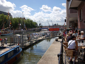
MY WIFE Jane and I have lived in Bristol for 20 years. We’ve made a home, raised four children and forged good friendships here. But we’d never actually stepped back and had an appreciative look at the city.

Bristol is not just the vibrant capital of the West Country, and it’s not simply a handsome old city with a salty, seafaring history. It’s the sort of place you land in as a youngster, to go to college or take up that first job, and then somehow never leave.

The heart and soul of Bristol is the magnificent Floating Harbour, a sinuous stretch of water lined with ships and waterfront bars at the core of the city, and that’s where we decided to base ourselves for our non-travel mini-break.

MORNING EXCURSION

On a brisk but sunny morning we hopped aboard one of the Floating Harbour’s busy water taxis (0117 927 3416/www.bristolferry.com) that buzz between a dozen embarkation points along the city’s waterfront.

As the boat plied the water between old warehouses and eyecatching new apartments, the fascinating history of Bristol – merchant harbour, slaving port, transatlantic money market, wartime target and revitalised leisure waterfront – passed before us like a living pageant.

Up on the cobbled quay of Welsh Back we headed off to explore St Nicholas Market – a charming scramble of wooden kiosks and booths selling everything from second-hand books and bike tyres to Bristol Blue Glass and ancient Dinky toys, all under a classic glass roof on elaborate Corinthian pillars.

GRAB A BITE

I could have fossicked in St Nick’s Market all day, nibbling Smokey Joe pies from Pieminster’s stall, but Jane had other ideas for lunch – namely a glass of sancerre and a bowl of hot and piquant fish soup at the River Station (0117 914 4434/www.riverstation.co.uk) on The Grove.

This former river police station with its picture windows and cool but friendly service is a firm favourite with Bristolian lunchers à deux. We got a table looking out over the Floating Harbour, and watched the gulls drift by for a blissful hour.

AFTERNOON ATTRACTION

In the city forever associated with the greatest of all Victorian engineers, Isambard Kingdom Brunel, it would be sacrilege not to pay a call to SS Great Britain (0117 926 0680/www.ssgreatbritain.org) the iron-hulled ship that lies in the very dock from which she was launched in 1843.

Jane and I had visited the ship before, but not since her great overhaul. You can hire her saloon for a private wedding feast or join historical tours of the ship. Better still, simply wander at will; from grand saloon to engine room, from first-class cabins to steerage passenger hellholes.

It has also been fitted out with life-size waxworks of crew. Admission: £10.95 adults, £5.65 children.

SUNDOWNER

Back on the Floating Harbour we made time for a quick pint outside the Cottage Inn (0117 921 5256). Why hadn’t we ever visited this friendly watering hole on Baltic Wharf, with its Bristol-brewed beers and views of scudding dinghies? Never mind – we were on to it now and would return.

DINNER DATE

We might have chosen any one of dozens of excellent eateries in the city. But one glance into the Bistro restaurant of our night’s stopover, the Hotel Du Vin on Narrow Lewins Mead, and we agreed we could hardly do better anywhere else.

The subtly lit room looked rosy and intimate; lamplight glowed on musky walls and regiments of old green and brown bottles stood cheerfully guard on sills. Jane’s haddock was a smoky dream, she reported; my pink-roast duck ditto.
Room for spiced plums or some of that homemade coconut ice cream? Yes, but no time if we wanted to catch some music.

ON THE TOWN

We hared over to the Old Duke (0117 927 7137/www.theoldduke.com) on the cobbles of Welsh Back for a drop of “filthy jazz”, courtesy of Cass Caswell and his almighty Allstars. Through Dixieland to bebop, Mr Caswell and chums drove our head-pumping crowd, a sweaty and steamy triumph of music over elbow-room.

The Old Duke is a seven-nights-a-week, cheek-by-jowl jazzer’s paradise where blues and rock are also smuggled in from time to time.

SLEEP EASY

It felt strange to be staying in a hotel only 10 minutes’ walk from our house. Bristol’s Hotel Du Vin is a highly imaginative conversion of an 18th-century sugar refinery and you just couldn’t ask for a friendlier stopover.

A home from home, in fact – if our home happened to have a 7ft-wide bed, a bath big enough to accommodate three close friends, and cheery faces saying “Certainly!” to every request.

Proper job, as they say down here.

INFORMATION: Hotel Du Vin, The Sugar House, Narrow Lewins Mead (0117 925 5577/www.hotelduvin.com) offers
doubles from £140 per night (two sharing), room only. Bristol Tourist Information Centre: 0906 711 2191/www.visitbristol.co.uk


 Posted by at 00:00
Oct 132007
 

Cyclamen were glowing pink under the beech trees on Mengore Hill in the mild Slovenian autumn air. But even their beauty, and that of the Soca River seen winding in milky turquoise bends between the mountains of the Julian Alps, could not soften the chill that went through me at first sight of the gun caverns.

Their naked rock mouths, opening like black wounds in the flanks of Mengore, had not healed at all in the 90 years since the horrific fighting of the First World War, when they belched smoke, flame and bullets again and again down the steep slopes of this hill.

"The Italians were up there on the Kolovrat ridge," remarked Edward Granville of Upland Escapes, pointing west to a long green mountain back. "When the fighting started in earnest in 1915 they selected their crack troops, their bersaglieri and alpini mountain fighters, to attack the Austro-Hungarians. But after a year or so they were using pretty much anyone who could be made to go over the top.

There were 11 major Italian offensives on the Soca Front – the Isonzo Front, as the Italians called it – trying to break eastward into Austria, but they never did get through." Edward gestured down the slope. "You can see why." The cause of the Italians' failure to take Mengore Hill was all too obvious. The hill is only a pimple compared with the majestic mountains round about.

But its slopes rise at an angle of 1:2 – in places, far steeper than that. A heavy-laden infantryman with a rifle to encumber him, a frightened young conscript already demoralised by one bloody repulse after another, outlined against snow or pale grass as he stumbled upwards among the decomposing corpses of previous assaults, made an easy target for an experienced machine gunner or sniper securely ensconced in a solid rock cavern high above. Mengore Hill, and the other hills and mountains around it, were like the battlefield of the Somme tilted at 45 degrees. The advantage was all with the dug-in defenders.

Upland Escapes specialises in walking holidays in carefully selected areas that other organisations don't frequent. Generally these settings lack such ferocious and poignant history. The company's Slovenian tour, however, goes right to the heart of the Alpine region contested so bitterly between the Allied forces, represented here by Italy, and the armies of the Austro-Hungarian Empire.

In this 90th anniversary year of the last and greatest of the Soca Front battles, Edward had come out to Slovenia to guide me through a stunningly beautiful mountainous landscape, where over 29 months, and on a front less than 50 miles long, more than a million Italians and nearly 700,000 of their opponents – Austrians, Bosnians, Poles, Hungarians and Germans – died or were mutilated for life.

What these enormous armies were doing, entrenched opposite each other along the Soca River mountains only a few hundred feet apart, exactly mirrored the positions of their respective Allies 1,000 miles away on the Western Front in Flanders.

The Italian commander, the stubborn and autocratic General Luigi Cadorna, convinced himself after each catastrophic repulse that the next strong push, if determined enough, would achieve a complete and decisive eastward breakthrough – a "stroll to Vienna" – and victory. The Austro-Hungarian troops held most of the vital high ground and were determined to prevent that breakthrough, while awaiting their own chance to advance westward into the Friulian plain of northern Italy.

The stalemate produced a campaign as bloody and terrible as that on the Western Front, but one which – apart from Ernest Hemingway 's classic and romantic account of it in A Farewell to Arms – has remained all but unknown outside Italy, Austria and Slovenia.

By another row of defensive tunnels beside the path up Mengore Hill, Edward and I found a noticeboard with two faded black-and-white First World War photographs of this same location. The soldiers have built wooden "houses" out from the stark rock of the tunnel mouths; they have knocked up rough benches and tables where they sit amid wild flowers trained up into a tiny garden – touching efforts by lonely men separated from their families to bring a touch of the domestic and familiar into a place of filth, noise and death.

At the top of the hill we came to a chapel. From here Edward pointed out the mountain ridge where a young Erwin Rommel (later to become the famed and feared "Desert Fox" of the Second World War) won the coveted Blue Max decoration, storming the hilltop during the Austro-Hungarians' one great victorious offensive of October 1917.

Before that military triumph broke the stalemate on the Soca, General Cadorna (who never came nearer the front than Udine, nearly 50 miles away) drove and punished his troops with threats, demotions and executions to undertake 11 fruitless and fatal assaults on the impregnable Austro-Hungarian line. I saw more of these fortifications on another climb, this time up the domed hill of Humèiè in the northern sector of the line.

Here in the damp beech woods and autumn crocuses, the black mouths of the gun caves and their connecting tunnels yawned in the impossibly steep slope of a hill where thousands died.

My three-night stay was based at the farm of Vinko and Irena Kranjc in the upland hamlet of Koseè, under the 7,400ft peak of Krn, the highest mountain of the region. Everything you eat and drink is produced by the Kranjc family from their bursting orchards and lush green pastures. Near this homely paradise two contrasting museums filled out the Soca Front picture.

In the neighbouring village of Drenica, Mirko Kurinèiè has spent 40 years filling his attic with items collected from the battlefields. Displayed here in profusion are helmets with bulletholes, spoons and forks, homemade snow shoes, shell caps, diaries discovered under rocks, propaganda postcards ("Is your girl getting off with a spiv back home while you're dying on the Isonzo?"), and chest and groin protectors crudely forged of cast iron.

Very different is the immaculately organised, award-winning museum in the nearby town of Kobarid. A huge scale model of the entire region helps you appreciate the relative positions of the combatant armies.

But it is the contemporary photographs that leave you stunned and silent – Italian corpses contorted by gas attack, zigzag lines of soldiers toiling up snowy slopes, a field hanging of a "coward", bodies stacked like firewood, faces blown apart and crudely reconstructed, a naked man under the knives of bloodied surgeons while a general looks on with a smile of polite inquiry.

Kobarid is known to Italians as Caporetto, a name synonymous with disaster. The two museums furnish facts, figures and images of what happened on October 24, 1917 when the Austro-Hungarians initiated their first and final offensive on the Soca Front. A beautifully restored section of the Italian front-line trenches at Predolina just north of Kobarid gives an idea of the environment in which the young men fought and died.

But I only caught the terror and futility of the battlefield when I climbed with Edward high above Predolina on to the crest of the ridge around which the Austrian advance surged towards the north Italian plain.

The October 1917 Austro-Hungarian offensive would eventually grind to a halt in northern Italy on the Piave River, more than 100 miles to the west, a stasis that would last until the overall Allied victory in November 1918. The Italian troops high on this knife-edge ridge, however, reeling from the shattering effects of Austrian mines exploding under their trenches, hearing the shouts and screams of battle in the morning mists below, then fleeing headlong down the slopes of Mount Vrsiè to captivity or death in the valleys, knew nothing of the future.

Staring out across the mountains from the ridge today, it's hard to imagine a more serenely peaceful prospect. But the terrified and half-frozen young men who left behind their fish tins, their helmets, their barbed wire and their boot soles remain ghostly presences.

Soca Basics

From London Stansted, Ryanair (www.ryanair.com) flies daily to Trieste and Easyjet (www.easyjet.com) flies to Ljubljana. Hire car and onward route instructions included in Upland Escapes package. Upland Escapes (01367 851111, www.uplandescapes.com) organises flexible, independent holidays in beautiful, unfrequented upland areas. These include group or solo walks and cycle rides, guided or self-guided, from easy to challenging.

In Slovenia it has a choice of 20 self-guided walks, five escorted walks and four cycle routes, several featuring Soca Front sites. Breaks cost from £615 per week, including hire car, escort/guide, local b & b accommodation, packed lunch, maps and guidebook. Three-night minimum stay.

 Posted by at 00:00
Sep 222007
 

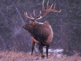
An answering roar, deep and melancholy, echoes from the hillside opposite. “Ah, there they are, dear old boys, giving each other the early warning,” smiles Richard Eales, Exmoor National Park Ranger of several years’ experience and a born deer fanatic.

“There are about 4,000 red deer on Exmoor,” whispers Richard. “The stags can tolerate each other’s company most of the year, in a laddish sort of way – a fair amount of bumping and barging, and even a bit of boxing with their forelegs when their new antlers are growing and itchy.
“But come this time of year, a hint of rough weather gets the old hormones flowing. Their necks thicken up into a big, dark mane and they get all edgy and restless. That’s when they have to collect a harem and try to hold on to it.”

The throaty roar, like a turbo-charged ram in full voice, comes up from the edge of a wood that we’re cautiously approaching. “Some call it belling, others say boving,” Richard murmurs. “It’s a challenge and a threat. Usually that’s enough to keep a rival away, but sometimes two stags will come face to face. If they’re serious, it’s heads down and let’s get to it.

“Lots of people think they fight to the death, but normally it’s just a clash of antlers. Or you’ll see them walking round each other, sizing one another up, like two blokes in a pub – ‘Come on, then, if you think you’re hard enough’, that sort of thing. Then one will back off, and it ends there.”
Hunched down and tiptoeing through the wet grass, we creep towards a five-barred gate.

Here he comes, cantering into view a couple of hundred yards away, a magnificent stag with heavy antlers and a big muscular body. He launches himself clean over a five-foot barbed-wire fence and then a hedgebank before charging straight up the hillside towards his opponent, who’s guarding a small hind – sole member of his harem.

The other stag skitters about nervously. And a particularly loud roar seems to convince him that the game is not worth the candle, and he backs away and moves uphill.
The victor stops to bell a couple more times, then turns his back and makes his way downhill and into the wood. Behind him trots the hind, now his exclusive property – unless and until some new stag, bigger, stronger or more aggressive, can manage to lure her away.

Crouched by the gate, we draw breath at the conclusion of this drama. “That one up on the common has to start all over again,” Richard says. “And this one in the wood, he’ll have one more hind to guard. And that’ll go on for another month or so, until the rut’s over and he’s mated with as many hinds as he can. The stags get really run down by the end of it, all thin and on edge.
“They’re absolutely knackered, poor old boys. Come to think of it – I was up at five this morning, so I’m feeling a bit that way myself. Fancy a cup of tea?”


 Posted by at 00:00
Aug 182007
 

Splashing through the shallows of the River Torridge, I was keeping half an eye out for otters. I knew my chances of seeing Tarka or one of his ilk mid-morning – even such a beautiful, hazy spring morning as this – were minimal.

Otters are essentially nocturnal creatures, and very shy of humans. But a mother and cubs had recently been spotted by day nearby, a mile or so downriver at Beam Weir. The sleekly furry little water-wanderers have been reported spreading once more along the rivers of North Devon after decades of near-extinction. Here in the country of the most famous – though fictional – otter of them all, I just couldn't prevent myself hoping against hope.

Henry Williamson wrote Tarka the Otter 80 years ago, covering hundreds of miles on foot with the local otter hunt and uncounted more on solo expeditions as he researched his story meticulously.

Wandering in his footsteps today around North Devon and the Country of the Two Rivers, Torridge and Taw, I found it quite astonishing to discover how little had changed at otter's-eye level – or, to put it another way, just how careful and accurate had been Williamson's descriptions of the river banks, the flood islands, the trees and meadows, the bridges, the flowers growing among the stones.

Roads have been built, railways closed, new housing thrown up around old town centres since Williamson lived and roamed here. But the rivers and woods, the high bogs and heather tracts of Exmoor have altered remarkably little.

Henry Williamson, born in 1895, served in the trenches during the First World War. This extremely sensitive, highly strung and romantic soul never recovered from the horror and the disillusionment he experienced in Flanders. From 1921 onwards he buried himself in the little North Devon village of Georgeham, seeking an escape from inner torment by exploring and writing about the wild and unfrequented landscapes of Exmoor.

When Tarka the Otter won the Hawthornden Prize for Literature in 1928, fame came, too. But it didn't make Williamson happy. He was a prickly customer, an outsider, who could be witty and charming or crushingly rude and intolerant as the mood took him.

In the 1930s he embraced Fascism with a naïve conviction that turned many of his friends against him. He almost drove himself mad, and did drive his family to despair and eventual break-up, by taking on the reclamation of a derelict Norfolk farm during the Second World War.

After the war he returned to Georgeham and spent much of the rest of his life in a spartan writing hut he built on the hill above the village. He died in 1977, author of dozens of books, recipient of no honours or public recognition.

All this sadness was far from my mind as I commenced my wanderings in the pawprints of Tarka. Through my hands in childhood had passed most of Henry Williamson's nature writings – Salar the Salmon, The Old Stag, Tales of Moorland and Estuary and, of course, the incomparable Tarka the Otter.

I loved them all – their romance and high adventure, their tiny details and flashes of humour, their absolute truthfulness to nature. The countryside of North Devon was for evermore to be seen by me through Williamson-coloured spectacles. For me he remains the supreme writer of the English countryside.

I started in the middle of Exmoor, its loneliest stretch of ground up at Pinkworthy Pond and the bare sweep of moorland known as The Chains. Heather and coarse grass squelched under my boots, water squirted with every step and the sharp, spring wind carried a curlew's mournfully bubbling cry.

Tarka would recognise the steely waters of Pinkworthy Pond where he hunted for frogs, and the remote goyal or valley of the Hoaroak Water down which he journeyed to the sea at Lynmouth. It was a boggy footpath that carried me seawards on the otter's track, a section of the 180-mile Tarka Trail whose waymarks I came across time and again on these foot expeditions in Henry Williamson country.

Down on the East Lyn Water I came to Watersmeet, a renowned beauty spot where the Hoaroak Water tumbles to meet the East Lyn among trees. Here, Tarka grappled with his mortal enemy Deadlock the otterhound, escaping hound and hunters to make his way to the sea and the safety of the coast.

I followed the cliff roads round to the great westward-facing scoop of Morte Bay, two miles of shining sand enclosed between the sentinel headlands of Morte Point and Baggy Point. Surfers were making the most of the wind-whipped rollers in the bay as I sat looking out to the Morte Stone, a rock rising from the tiderips where Tarka hunted bass. Later I caught the last of a spectacular red sunset out at the tip of Baggy Point, a favourite haunt of Henry Williamson's when he was living at Georgeham a mile or so inland.

In the morning I followed the final act of the Tarka drama from Great Torrington down the River Torridge, biking and hiking along the Tarka Trail from the mill house where Tarka hid on the waterwheel (still there) at the start of the hunt to the mouth of the estuary where the otter closed with Deadlock the hound and dragged him down to drown in the ebbing tide.

As the hunters stood round the body of the hound, "a great bubble rose out of the depths and broke, and as they watched, another bubble shook the surface, and broke; and there was a third bubble in the sea-going waters, and nothing more." So passed Tarka.

My last day in Williamson's North Devon I spent mooching around the writer's adopted village of Georgeham. The thatched cottage that he rented for £5 a year, last in a short row under the church tower, still carries the name he gave it, Skirr Cottage.

Just up the lane, a blue plaque has been fixed to the house to which he moved as his family expanded. But there's not a great deal else in Georgeham to commemorate the man who lies between Skirr Cottage and church tower under a black slate stone inscribed with his barn owl colophon or trademark and the simple comment, "Here rests Henry Williamson".

Up on the hill above the village at Ox's Cross, Williamson's writing hut is preserved in the grove of pine trees he planted. The views over fields, estuary and moor are stunning.

Inside the elm-board hut he built, Williamson's boots stand against the wall and his tatty old plaid jacket hangs across the back of his chair. A pair of spectacles lie folded on the blotter, as if their owner had just laid them down to go outside for a moment. I could easily believe that the man himself might appear in the doorway, perhaps to blare out, "What the bloody hell do you think you're doing in my hut?" – or maybe to allow me to shake his hand and tell him how his masterpieces of country writing had shone like beacons of delight in a boy's imagination.

Essentials

Getting there

Rail to Barnstaple (08457 484950, www.thetrainline.co.uk). Car: M5 to Jct 27, A361 to Barnstaple.

Getting around

Maps OS Landrangers 180, 181; Explorers OL9, 139.
Tarka Trail 180-mile circular walking trail connecting many Tarka sites. Meeth-Braunton (32 miles) suitable for cycling. Free Tarka Country leaflet with map, places to visit, information on cycle hire, refreshment stops: call 01271 336070.
Bike hire Torrington Cycle Hire, Station Yard, Great Torrington (01805 622633 ); Tarka Trail Cycle Hire, Railway Station, Barnstaple (01271 324202 ); Biketrail, The Stone Barn, Fremington Quay (01271 372586/07788 133738, www.biketrail.co.uk); Bideford Bicycle Hire, Torrington Street, East-the-Water, Bideford (01237 424123).

Staying there

Yoldon House Hotel, Durrant Lane, Northam, Bideford, EX39 2RL (01237 474400, www.yeoldonhousehotel.co.uk): stylish and welcoming, on the Torridge Estuary; double b & b from £110; short-break deals available.
The Croft, Ox's Cross, near Georgeham (inquiries 01271 816345, www.coastal-cottages.com): cottage where Henry Williamson lodged; self-catering weekly rate from £225 (low and mid-season), £545 (high).

More information

  • Henry Williamson Society (webmaster@henrywilliamson.co.uk, www.henrywilliamson.co.uk) offers talks, meetings, books, tapes and videos on the life of Henry Williamson. UK adult membership, £12; family, £15. Members can visit Williamson's Writing Hut at Ox's Cross, by arrangement.
  • Barnstaple TIC, The Square, Barnstaple (01271 375000, www.discoverdevon.com). Among useful publications available here are Tarka Country Explored by Trevor Beer, Pub Walks Along The Tarka Trail by Michael Bennie, and Henry Williamson, A brief look at his Life and Writings in North Devon by Anne Williamson and Tony Evans.
  • Background reading Tarka the Otter by Henry Williamson (Puffin Modern Classics, £6.99). The Illustrated Tarka the Otter (Webb & Bower, 1985), with photographs by Simon McBride, is out of print but obtainable on-line.
  • www.northdevon.com
 Posted by at 00:00
May 052007
 

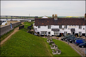
‘Cloud Nine, that used to be,’ says Chris Fenwick, as we gather round him on the Canvey Island sea wall. He points across Parkin’s funfair to a little upstairs clubroom beyond. ‘That’s where Dr Feelgood played their first gigs, a few dozen jammed in, a few quid if we were lucky, plus a pint each. I was really green as their manager then, but I knew enough to count the punters on the door!’

Pekka from Finland, a doctor by day and a Feelgood tribute band member by night, has a question – so when did things actually take off for Dr Feelgood? The Big Figure, the Canvey-born-and-bred R&B heroes’ original drummer, has been strolling the sea wall with us, a dozen outdoor-minded souls out of the hundreds of fans and followers who have come down to the ‘Canvey Delta’ – as we affectionately term this muddy, marshy corner of the Thames Estuary – to worship at the shrine of ‘the greatest local band in the world’. Now he nods. ‘Things kicked off big style when we started hitting the London pubs, forty miles up the A13 that way.’ The Big Figure points a leather-jacketed arm west up the murky Thames. ‘That was the pub rock scene back in the ‘70s. Bang! We were off and running. But Canvey was the backdrop, our home town, a very unpretentious and down-to-earth place. We were Canvey boys, pure and simple. Canvey made us all what we were. And we didn’t ever let each other forget that.

Lee Brilleaux, the gravel-voiced frontman of that famous first incarnation of Dr Feelgood, died of lymphoma in 1994. In his honour Feelgood fans gather in Essex from the four corners of the globe every year on the weekend nearest his birthday, 10 May, for the Lee Brilleaux Memorial. Chris Fenwick, the band’s manager since Day One, steers us on a nostalgic walking circuit of Feelgood sites around the sea walls of Canvey Island – sometimes, if our luck is in, with former Feelgoods for company. Then we drink a bathload of beer in the tiny, atmospheric Canvey Club, before sending the Oysterfleet Hotel reeling with a night of gale-force R&B. Revered rockers from the area – Eddie and the Hot Rods, the Kursaal Flyers, Larry Wallis of the Pink Fairies and Motörhead – jump up on stage with the current Feelgoods to trade Telecaster licks and thunderous drum fills. It’s a sweaty, chaotic, brilliant night, with any oversize egos left at the door and all proceeds to a local community nursing team.

Canvey Island, the flat piece of reclaimed marshland shaped like a horse’s skull that lies off the Essex coast of the Thames Estuary between Tilbury and Southend-on-Sea, is a Feelgood fan’s R&B Shangri-la. Where others see only a bleak shore seeded with chemical silos and cheek-by-jowl housing, we scent romance and adventure. No matter that many of us have come to know the real Canvey well, and have made good friends among the Canvey islanders. The moment we cross East Haven Creek we enter a parallel universe – the chancy but captivating world of Oil City where men are men and women are vixens, where devastating dames tap their scarlet nails on your wallet, and dodgy motors are forever screeching up with just the kind of bourbon-guzzling characters you’d step off the sidewalk to avoid.

It was Wilko Johnson, the Bard of Canvey, who created this fantasy island in our minds back in the early 1970s when he was Dr Feelgood’s guitar-slinger supreme. The Feelgoods were Canvey to their boot-heels, a quartet of sharply-dressed R&B belters who burst through the soft underbelly of the jaded post-Beatles music business like an uppercut from a private dick. Gruff-voiced Lee barked out the 100 mph, three-minute-maximum songs; John B. Sparks thwacked a bass impassively; the Big Figure played whipcrack drums. Wilko Johnson, meanwhile, thrummed his Fender Telecaster like a stuttering machine-gun and jerked around the stage like a bug-eyed madman. But the guitarist was far more than simply a showman. Wilko was a rock’n’roll poet, a master craftsman of tales and tunes. The songs he wrote presented sharp cameos of cheerful chancers down on their luck, of cheating girls and hard men, citizens of a harsh yet lively town he called ‘Oil City’. Each miniature chronicle came across as pungently and economically as a Raymond Carver short story.

‘Back when we were starting out,’ Lee Brilleaux once told me, ‘Canvey had an element of toughness, like most working-class places. Men were expected to be men. If you wanted to find a fight, you only had to spill another man’s beer or look at his wife. But there was a warmth about it as well. The funny thing was, Canvey was really a rural community in lots of ways. Everyone on the island knew us kids, and they’d look out for us. I grew up playing on the creeks, building pirate dens out on the marshes – a country boy’s background. We knew about tides, about birds and shellfish, alongside the bookies and the boozers.

Wilko’s Johnson’s songs did not exactly detail the real Canvey Island, but they played around with it as a setting and an atmosphere. In Wilko’s Oil City, his hard-boiled protagonists watched the refinery towers burning at the break of day as they waited for some red-eyed rendezvous; they went places and stayed too long; they jumped up right out of a dream to find the front door wide open and the rain blowing in from the street. If a Wilko Johnson character was faced with an unfaithful girlfriend, he wouldn’t lose his cool or burst into tears: no, he’d just rasp, ‘I’m gonna get some concrete mix and fill your back door up with bricks – and you’d better be there waiting when I get my business fixed!’

One way of discovering Canvey Island – the Feelgood version – is to turn up at the Lobster Smack Inn on the sea wall on Memorial Friday morning, and join we Feelgood walkers on our R&B pilgrimage. Or you can nose it out on your own. The sea wall path runs right round the island, a superb 14-mile expedition. You can walk the eastern half with its tight-packed streets and shell-sand beaches, its marshes and huge estuary views. Or start at Benfleet station, cross the creek onto Canvey and strike out round the green western end, strolling for hours with only oystercatchers and marsh horses for company before ducking into the Lobster Smack for plaice and chips and a pint. Charles Dickens, that supreme appreciator of lonely marsh country, had Pip and Magwitch hiding out at the Lobster Smack in Great Expectations, and the old pub under the sea wall still somehow retains a tang of remoteness and of idiosyncrasy.

Wilko and his three Canvey Island compadres parted musical company long ago. The guitarist tours with his own band these days. Dr Feelgood are still on the road, too, other musicians having slipped into the shoes of the original Feelgoods over the years. Now the dust has settled, it’s no strange thing to see them all up on the stage on Memorial night, giving it plenty. And that’s what happens when Pekka and I swagger into the Oysterfleet this evening with our crowd, some sorefoot from the walk, all thirsty, all up for it – whatever ‘it’ might turn out to be.  

Dennis the Dog is on the door and we give him a respectful hello. Then it’s into the ballroom, pints in hand. On the stage Wilko Johnson, the Big Figure and sundry band members past and present are giving the Feelgood songbook a good sound thrashing. ‘I looked for my baby all over in town,’ sings Wilko, up to the mic and back again with his tense clockwork strut, ‘I never seen so many women since the time they closed the factory down.’ He grimaces, bulges his eyes menacingly. ‘Midnight on the river, by the light of the flames; I’m staring at the water and I’m trying to fit a number to her name.’

We’ve stared at that water, too, today, and have seen the light of the flames flaring from the pipes on Shell Haven oil refinery. I stand wedged in between Pekka and Chris, glorying in the sheer escapist pleasure of hearing those tight, razor-edged Oil City tales of drinking, cheating and losing the plot as they should be heard – live, loud, and right here in their Canvey Island birthplace.


FACT FILE

Travel: Rail to Benfleet (08459-484950; www.thetrainline.co.uk), then taxi (01268-693355 or 680865). Car from M25 – Jct 29, A127, A130; Jct 30, A13, A130

Staying:Oysterfleet Hotel, Knightswick Road, Canvey Island (01268-510111; www.oysterfleethotel.de) – £56dble B&B.Lee Brilleaux Memorial Walk: Friday 11 May 2007; meet at Lobster Smack Inn, Canvey Island sea wall, 10.00-ish.

For details of gigs, recordings, Lee Brilleaux Memorial and all other information about Wilko Johnson and Dr Feelgood, visit www.drfeelgood.org

 Posted by at 00:00
Mar 312007
 

Driving north across the plains of Extremadura I ran into an army of dust devils. Whipped up by the cold winds of spring, they rushed bowing and whirling across the flat landscape. In the vast fields the tiny figures of Extremaduran farmers, digging and hoeing in timeless labour, hardly bothered to look up as the spirals of dust and last year’s holm oak leaves sped by them.


Groves of crusty-barked cork trees, orchards foaming with pink and white blossom, rows of stumpy vines pruned hard back to the dark earth, brimming ditches lined with thrashing reed beds and whistling willows – these signs of a fruitful land were suddenly extinguished by a slate-grey curtain of rain marching in from the low dark sierras on the western horizon. All was blotted out. Five minutes later Extremadura re-emerged, arched over by a superb double rainbow in front of which flew a leisurely line of cranes, their ragged wings taking them north to their boggy breeding grounds thousands of miles from Spain. Rain, cranes, sharp winds and labouring farmers – all was exactly as my friend Frank Caňada, born-and-bred Extremaduran exiled to Britain, had described when he urged me to spend a few days of early spring in his native village of Navalvillar de Pela.


Spring and autumn bring the rains that turn the soil rich and the grass green, and they also see birds by the million on migration. Yet the regional name of Extremadura (‘extremely tough’) has been hard earned. This is a place that bakes in 40o of heat in summer and freezes in sub-zero temperatures when winter strikes. And tough describes its people, often forced by poverty to emigrate, fiercely proud of their traditions, conservative to the backbone.


Ten minutes after knocking at the door of Frank’s parents, Antonio and Petra Caňada, I was sitting at their dining table, eating Petra’s home-killed pork and drinking tiny tumblers of Antonio’s home-made wine, with my rain-chilled feet perched to warm on the rim of a giant bowl of glowing embers. This was central heating, Navalvillar de Pela style, and I couldn’t get enough of it.


Conversation spat and sparked as my Spanish phrase book took a battering. Antonio smiled ferociously at me from under his brows, an expression I well remembered from my previous visit to Navalvillar. That had been on a frosty January night, on the occasion of the village’s horse-centred Festival of San Anton. A confirmed and cowardly non-rider, I had found myself galloping recklessly between bonfires through the town’s narrow streets, under a starry sky. It was Antonio who had grasped me by collar and waistband and thrown me bodily up onto the horse before I could demur. Now, recalling my terror on that distant night, he smacked his legs and roared with laughter.


I lodged in the Casa Rural La Lozana in a back lane of Navalvillar – one of those splendid Spanish rural guesthouses that for neatness, stylishness and sense of welcome put most British B&Bs to shame – and spent every waking hour with the Caňada family. One day we picnicked by a lake in the Sierra de Pela, and I climbed with Antonio to a peak jewelled with violets and daisies. On Sunday, a beautiful cold day of blue sky, we went to church among flocks of black-clad crones, and I recognised the priest as the one who had stood with holy water on the Feast of San Anton to bless the cattle, horses, dogs, hamsters, cats and goldfish brought to the church by members of his congregation.


One day I spent on my own, venturing north through another rainstorm to the Monastery of Santa Maria at Guadalupe. This is arguably Spain’s most famous place of veneration. The huge walled monastery contains glittering treasure – paintings by El Greco and Goya, embroidered altar cloths, jewelled crosses; also an ivory Crucifixion, said to have been carved by Michelangelo, whose miniature Christ I saw kissed with great reverence by a young, black-clad woman. The monastery is also the setting for a tiny statue of our Lady of Guadalupe, so reverenced in medieval Spain that the Virgin of Guadalupe became patron saint of all Spain’s territories in the Americas. Dwarfed by angels, saints and pinnacles in her fabulously elaborate altarpiece, the Virgin stares serenely over the heads of tourists, guides and worshippers alike.


On a cold, cloudless morning I left Navalvillar and drove north. Fertile fields gave way to the harsher rock of the Sierra Brava. Snow capped the peaks, and the stone walls of the city of Trujillo shone pale on their high saddle of ground. Here I met up with Martin Kelsey, an expatriate Englishman who runs the Birding Extremadura company. Martin, I’d heard, might be able to get me within sight of that giant elusive bird of the open grasslands, the great bustard. Ever since learning in childhood of the extinction of Britain’s great bustards – hunted to non-existence on Salisbury Plain by 1832 – I had longed to catch sight of the big turkey-like birds with their handsome chestnut breasts and flashing white wings. The wide grassy plains of Extremadura, where male great bustards meet in spring to ‘lek’ (join in communal display) and mate with the rather drab females of their species, seemed my best bet, especially under the expert tutelage of a guide as experienced and passionate as Martin.


First, though, we took a swing through the city of Trujillo. It is just the right size to walk around in half a day, an evocative jumble of medieval houses and tight, steep lanes centred round a square where Francesco Pizarro stands a-triumph in statue form. The ruthless conquistador, who with his 180 men suppressed the Inca nation in the 1530s, inspired others to grow rich on the blood of South American peoples. Trujillo owed its prosperity to Pizarro and his followers. Nowadays he poses in the town square, sword on hip, staring from beneath his coal-scuttle helmet at the snogging teenagers and hurrying housewives of Trujillo.


My day with Martin yielded ornithological wonders – hen harriers flapping over the pastures, a colony of storks in a clump of dead trees, golden-plumaged griffon vultures and a rare black stork in cliffs above the River Tagus. It was nearer Trujillo, out in the broad green expanses of the Belen plain, that we went looking for my dream birds.


‘These are steppes,’ Martin pointed out as we drove down a bumpy road, ‘grasslands that have never been irrigated or intensively managed. They’re full of flowers and insects, and therefore of birds. Great Bustards do very well here – I reckon there might be five or six thousand in Extremadura.’


A stunning view opened out towards the snowy mountains. On a grass ridge not far away, chestnut-coloured dots were moving. Five magnificent male great bustards paced the ridge with long, powerful strides. Their white underparts, glossy brown necks and fox-red backs showed up dramatically against the sunlit green of the grass. We watched through Martin’s telescope as two of the birds bowed to each other, fluffing up their chest plumage and flicking their wings upside down to display the brilliance of the white under-feathers.


‘They’re practising lekking,’ said Martin. ‘In a few weeks’ time the females will be here, and these boys will have their work cut out to make their mark.’


Spring seemed stirring all over the steppes and sierras of Extremadura. Breaking free of its winter chains, the hard land felt full of vigour, full of life. I stood holding my breath, watching the great bustards flick from white to chestnut and back to white, and marvelled at my luck.


TRAVEL: FACT FILE


Getting there: Easyjet (www.easyjet.com) fly to Madrid from London Gatwick, Luton, Bristol and Liverpool; Ryanair (www.ryanair.com) from East Midlands to Madrid and Granada, and London Stansted and Liverpool to Seville; Iberia (www.iberia.com) from Madrid to Badajoz   


STAYING: Navalvillar de Pela – Casa Rural La Lozana, Calle Moreno Nogales 18, 06760 Navalvillar de Pela (Badajoz). Tel 00-34-924-824-291/924-860-428; www.lalozana.com. Dble B&B from around £42.


Trujillo – Casa Rural El Recuerdo (Martin and Claudia Kelsey), Pago de San Clemente, Apartado de Correos 28, 10200 Trujillo (Càceres). Tel 00-34-927-319-349; mobile 609-684-719/609-684-631; www.birdingextremadura.com. Dble B&B from £45; evening meal inc. wine £12.


BIRDING EXTREMADURA: www.birdingextremadura.com. Guided tour including packed lunch: £75 (1 person), £85 (2), £90 (3).


INFORMATION: www.spain.info

 Posted by at 00:00