First published in: The Times Click here to view a map for this walk in a new window


Facebook Link:

Cuilcagh is an eye-catching mountain. It stands lone and proud, straddling the border of Northern Ireland and the Republic, a long table of a mountain, isolated in a vast expanse of blanket bog.
;)
Jane and I had admired Cuilcagh’s upstanding ridge for years, a backdrop to dozens of walks in Counties Fermanagh and Cavan. But starting off from Gortalughany viewpoint on a morning of sun and cloud shadows, we had no idea of just what a wet and squelchy walk it would be to reach the mountain.
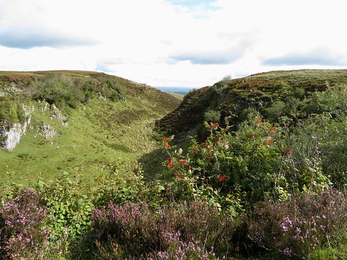
The blanket bog of peat that encompasses Cuilcagh, thousands of years old and ten feet thick, has trapped an awful lot of water. Some of it runs into swallow holes in the limestone pavements of the northern slopes, to reappear miles away and lower down – the Shannon, Ireland’s chief river, has its origin here in this manner. But on the sandstone and shale that underpin Cuilcagh itself and its surroundings, the bog lies sodden and juicy.
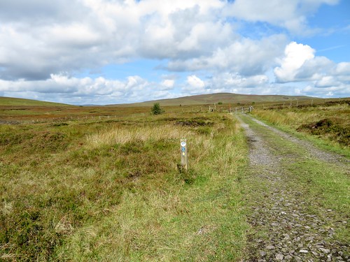
Driving up to Gortalughany, we spotted the small, dark cross shape of a merlin gliding out over the valley. A pause to look north and east across the shattered mirror of Upper Lough Erne and its thousand lakelets and drumlin islands, and we set off across the bog following the Cuilcagh Way marker posts that faithfully showed the way.
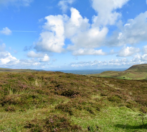
Orange spears of bog asphodel, brilliant purple buttons of devil’s bit scabious and the blue bonnets of insectivorous butterwort. A hum of bees busy in the heather, harsh cursing of ravens, and the sudden onrush of thousands of midges hungry for our blood. We leaped black bog streams, trudged the wet peaty path, and looked round to savour the absolute loneliness as the sun lit up great empty swathes of dun-coloured bogland, the green farmlands and blue Donegal mountains far beyond.
Arriving at last at the foot of Cuilcagh, we looked aloft up the route of the waymarkers, hardly able to believe our eyes. Really? Climb a grass slope as steep as that?
It was one hell of a scramble, by grass tuft and boulder, handhold and boot tip. But once up there at Cuilcagh’s summit cairn, burial place of some Bronze Age chieftain, we too were lords of a hundred miles of bog and mountain, field and forest in every direction. A might position in the sky, a reward for all our efforts.
Start: Gortalughany Viewpoint, near Swanlinbar, Co. Fermanagh BT92 (OS ref SA 257956)
Getting there: Signposted from A32 Enniskillen-Swanlinbar road, 2 miles north of Swanlinbar. Car park (free) at top of road.
Walk (8½ miles, strenuous moorland walk and short, very steep climb, OSNI Discoverer map 26; download map/instructions at walkni.com): From Gortalughany Viewpoint, ahead along road. In 300m, right over stile (‘Cuilcagh Way’/CW); follow stony track into Aghatirourke RSPB reserve (signed, CW). In ¾ mile, at top of Legacurragh Gap gully, at waymark post with many directions (248964), bear left across rough ground to CW post 100m away. From here follow CW waymark posts across bog for 2¾ miles to eastern foot of Cuilcagh Mt (214941). Follow CW markers up steep slope (grass, then scree and rocks) to summit cairn (212939). Carefully back down slope; follow CW markers back to Gortalughany.
Conditions: Very wet underfoot; take binoculars for spotting CW arrows (helpfully spaced).
A wild mountain walk and short, steep climb for experienced, fully equipped hill walkers – good weather only.
Lunch: Picnic
Accommodation: Lough Erne Resort, Belleck Road, Enniskillen, Co. Fermanagh BT93 7ED ()28-6632-3230; lougherneresort.com) – exceptionally comfortable, friendly, helpful hotel.
Info: walkni.com; discovernorthernireland.com; satmap.com; ramblers.org.uk