First published in: The Times Click here to view a map for this walk in a new window

A rain-spattered morning gave way to a brighter sky over the Welsh Borders. From the pastures south of Shrewsbury rose thickly forested Pontesford Hill, a double hump leading up to the Iron Age ramparts at the grassy crown of Earl’s Hill.
;)
A long stony track led up the flank of Pontesford Hill, steepening through pine and oak woods and the slender white stems of silver birch. The track was littered with fragments of pine branches torn loose by winter storms, among which lay little heaps of scales dropped from larch trees by feasting grey squirrels.
We stopped to watch one at his work forty feet above our heads. He sat upright, intense and efficient, balanced by his fluffed out tail, nibbling energetically at a cone held in his paws, neatly picking out the nutritious seeds and letting the scales fall spinning to the ground.
Rocks and tree roots offered slippery footholds as we went up to where the tattered trees of Pontesford Hill give way to the grassy slope of Earl’s Hill. Shropshire Wildlife Trust have plans to remove the failing conifers planted on Pontesford Hill in the 1960s and to restore a sheep-grazed sward for wild flowers and butterflies, an exciting prospect.
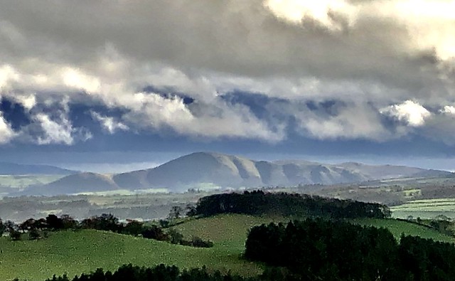
A great Iron Age hill fort encloses the elongated top of Earl’s Hill, and from here we gazed round a breath-taking 360o panorama, north to the Cheshire plain and its sandstone ridge, west to the Welsh hills, and south towards a rise of ground where the jagged outcrop of the Stiperstones broke the skyline. The big isolated hump of the Wrekin lay to the east, while away in the southeast the furrowed flanks of the Caradoc Hills were dramatically sunlit under a dark wave of cloud.
A broad tongue of grass led steeply off the hill and down into woods where celandines were beginning to show their miniature golden suns beside the path. At a mucky crossing of tracks, more slurry than solid ground, we turned northeast through sunny Oaks Wood and down to the rushing Habberley Brook in its dell below the cliff face of Earl’s Hill.
A path led downstream, crossing and recrossing the stream before heading for Pontesbury across shaggy pastures. Some of the wildlife ponds at Earlsdale carried a paper-thin skin of ice, and the afternoon sun put a shimmer on the water of those pools as yet unfrozen.
How hard is it? 4¾ miles; moderate; hill and woodland tracks, muddy in woods.
Start: Pontesford Hill car park, near Pontesford, Salop SY5 0UH (OS ref SJ 409057)
Getting there: Bus 552/553, Shrewsbury-Bishop’s Castle
Road – ‘Pontesford Hill’ is signed from A488 at Pontesford, between Shrewsbury and Minsterley
Walk (OS Explorer ): Pass bollards, up main track. In 350m, left up steps (408055, ‘Summit’); steeply up to summit trig pillar on Earl’s Hill (409048). Ahead, steeply downhill to stile (406043); right (‘Walk 17’). At foot of slope, left (405044, gate, ‘Ride UK’). In 500m at path crossroads (406039, gate), left (blue arrow/BA). In 200m, half right across field to gate/footbridge (409041, yellow arrow/YA, ‘Chris Bagley Walk’). Path through Oaks Wood. In ¾ mile at top of wood (417046) path curves left and descends; at bottom, right; immediately left (415048, BA, ‘Ride UK’) down to cross footbridge (415051). Right (BAs); in 250m, cross stream (416052, BAs); in 100m recross (416053, YA). Up to kissing gate/KG; keep ahead, following YAs and keeping Earlsdale ponds on your right, across fields to car park.
Lunch: Picnic; or Mytton Arms, Habberley SY5 0TP (01743-792490 – ring first for details!)
Accommodation: Prince Rupert Hotel, Butcher Row, Shrewsbury SY1 1UQ (01743-499955, princeruperthotel.co.uk)