First published in: The Times Click here to view a map for this walk in a new window

Facebook Link:
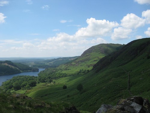
A warm day of sun and cloud over Galloway, the forgotten corner of south-west Scotland. Finch and warbler song echoed in the woods of alder and silver birch along the Water of Trool. A good squirt of Avon Skin-so-Soft, incomparable deterrent to the bluidy midges, and we were off along the river with the high hills of Galloway cut sharply against white cumulus and blue sky, the crumpled-bed profile of Mulldonoch standing tall across Loch Trool, the grey-green teeth of Cambrick Hill beyond.
Up beside the roughly squared lump of Bruce’s Stone we gazed across the head of the loch to the slopes where Robert Bruce’s ragged guerrillas had whipped the mail-clad asses of the English in 1307, rolling great boulders down on them and charging the demoralised remnants into flight. The tumbled hills around Glen Trool lay in mild sunshine today, as peaceful as could be. We crossed a miniature gorge of black rock walls by way of Buchan Bridge, and followed a hill path through the bracken into the lonely side cleft of the Gairland Burn.
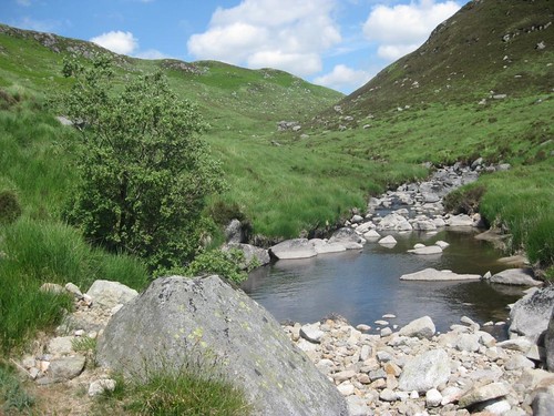
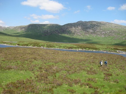
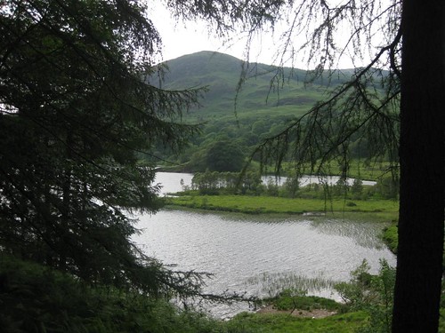
The Galloway hills hold many secret places, especially in these foothills of the wonderfully named Range of the Awful Hand. You’d never suspect it from down in Glen Trool, but a string of beautiful peat-dark lochs with white quartzite sand beaches lies above the Gairland’s glen. The hillside track led us up among boggy patches jumping with tiny green and yellow frogs, upstream beside the glassy oxygenated waters of the burn. We skirted steely dark Loch Valley and climbed beside ancient animal pens of massive boulders to reach imperial blue Loch Neldricken, its waters bright with bogbean, its white and salmon-pink beaches etched in crescents under the shoulder of The Merrick.
‘Ony sauchle o’ a body can write a book,’ a local shepherd growled to rural writer Rev C.H. Dick at the turn of the 20th century, ‘but it tak’s a man tae herd The Merrick.’ Looking at the great whaleback of Galloway’s highest mountain, we saw exactly what he meant.
Down in Glen Trool once more we crossed the head of Loch Trool and turned back along a swooping path through the forest. Cuckoos made call and response across the sunny valley, and the loch waters sparkled as though a generous, invisible hand had scattered diamonds there.
Start & finish: Car park at foot of Loch Trool (OS ref NX 297791)
Getting there:
Bus 359 (Newton Stewart-Ayr) to Glentrool village (www.dumgal.gov.uk)
Road: A714 Newton Stewart-Girvan. In 8 miles, right to Glentrool Visitor Centre. Follow ‘Bruce’s Stone’; in 1½ miles, right (‘Start of Loch Trool Trail’) to car park.
Walk: (5½ miles, or 10 miles inc. upper lochs; moderate, OS Explorer 318): Follow woodland path past ‘green waymarks’/GW sign. NB: GWs are posts with green bands; they carry white waymark arrows (on their reverse sides) for clockwise walkers!). In ½ mile enter conifer forest; in 200 yards, look for GW on left; climb track to road (402799). Right past Bruce’s Stone car park (416804); descent rough road to cross Buchan Bridge (418804); fork left and continue (GW; ‘Gairland Burn’). In 200 yards, at right bend (420805), Loch Trool Trail continues along road.
For Gairland Burn and upper lochs extension, go through gate and up hillside path (‘Loch Valley, Gairland Burn’). Follow track to Gairland Burn; continue up left bank. Near top, cross side burns (436818); keep near Gairland Burn to Loch Valley. Keep left of loch, then follow stone wall by burn up to Loch Neldricken. Return to gate near Buchan Bridge; rejoining Loch Trool Trail by turning left along road (GW).
In ⅓ mile cross Gairland Burn and continue; go through gate, and in 150 yards bear right off road (430801; ‘National Cycle Network 7’). Follow path to cross burn (430800); forward up side of forestry (‘Southern Upland Way/SUW’); left along SUW beside Loch Trool for 1¾ miles, to cross Caldons Burn footbridge and reach T-junction (399789) with SUW post, GW post and a blue post marked ‘7 Stones’. Bear right here to footbridge and car park.
NB: Online maps, more walks: www.christophersomerville.co.uk
Lunch: Picnic
Loch Trool Visitor Centre (01671-840302): light meals, maps, Avon Skin-so-Soft midge repellent!
Accommodation: Creebridge House, Newton Stewart DG8 6NP (01671-402121; www.creebridge.co.uk)
More info: www.visitscotland.com/gold