The sun beamed on bean rows and potato ridges in the gardens we passed on our way out of Borough Green.
First published in: The Times Click here to view a map for this walk in a new window


Facebook Link:
If Kent is the Garden of England, the stretch of idyllic countryside round this village on the northern edge of the Weald is a particularly lush corner of the vegetable plot. The trees are thriving well, too – there are enough deep pockets of forest left to give a flavour of how dense and green the sprawling old Wealden wildwood must have been before the Kentish ironmasters began stripping the ancient forest for charcoal.
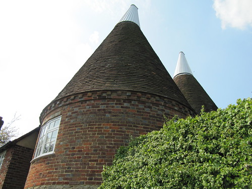
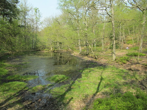
A tangle of bluebell woods runs down the twisting Basted valley, skirting the old millpond with its white-browed coots and delicately stepping moorhens. There were mills all down the River Bourne here, all gone now in favour of fabulous new houses. We walked the woodland paths past long-forgotten watercress beds, then climbed a flinty track onto the roof of the downs, with heat-hazed views over rolling, darkly wooded country. Near the triplet oasts at Yopps Green – how long since they last dried a load of hops? – we turned onto a bridleway and came down off the ridge to Ightham Mote.
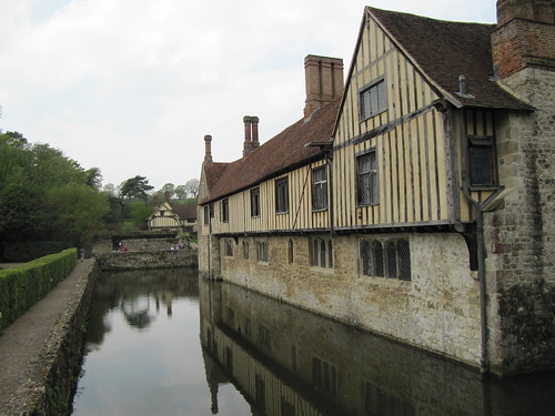
A dream of a moated Elizabethan manor, Ightham Mote contains a far older hall house, dark panelled and timbered. This ‘vile and papisticall house’, as it was styled in a Catholic-bashing report of 1585, is truly a place of secrets, of concealed passages and priest’s holes. Tales say that Ightham Mote is haunted by a Grey Lady, the ghost of Dame Dorothy Selby, who gave away the Gunpowder Plot by warning her cousin not to attend Parliament on 5 November 1605, and was walled up alive in the house as a punishment. It never happened like that – but who can stop a good gothic yarn?
We could have stayed all afternoon at Ightham Mote – most of the visitors seemed set to do that. Tearing ourselves away at last, we climbed steep Raspit Hill and followed the path over an overgrown common and into Oldbury Wood. One of the largest Iron Age hill forts in Britain lies hidden in the wood, its earthen ramparts rooted with oak and sweet chestnut. The invading Romans captured it from the Belgae warrior tribe in 43AD as they advanced towards the Thames – perhaps ‘with extreme prejudice’, if the burned defences and mounds of slingshots excavated here tell a true tale.
Picturing the mayhem, we followed the ancient trackway through the silent, tree-smothered old fort and out into the late afternoon sun.
Start & finish: Borough Green & Wrotham station TN15 8BG (OS ref TQ 609574)
Getting there: Train (www.thetrainline.com; www.railcard.co.uk) to Borough Green & Wrotham station. Road: M25 (Jct 5), M26 (Jct 2a); A20 to Wrotham Heath, A25 to Borough Green.
Walk (8½ miles, moderate grade, OS Explorer 147): From Borough Green and Wrotham Station (609574), turn right over the railway. On the following right bend, keep ahead along Borough Green’s High Street (with National Westminster bank on your right). Cross A25 at the end, and continue along Quarry Hill Road (‘Church’). Opposite the church, turn left (608572, ‘footpath’ fingerpost) and follow the footpath south out of Borough Green, crossing a couple of roads and keeping the same direction, to descent through woods to a road near Basted mill pond (607563). Turn left past the pond.
You pass a Southern Water pumping station on your right, and at the foot of Plough Hill fork right (607557) through the woods along the valley bottom. At Winfield Lane (606550) turn right uphill for 100 yards (100 m); then turn left over a stile (fingerpost) and on through an orchard. Cross a river and continue up a stony lane between orchards for two-thirds of a mile to the road in Yopps Green (602542).
At Yopps Green turn left along the road past the three oasts. Opposite White Beam house turn right (602540; concrete bridleway marker) along a bridleway. Keep heading west over crossing paths for a third of a mile (0.5 km) to a T-junction of paths at the top of a rise (596539). Turn right (‘bridleway’) for a third of a mile (0.5 km) through woods to A227. Cross the road (591541); bear left through a gate and along a bridleway (fingerpost). In 200 yards (200 m) bear half-right over a crossing of paths (591539) and continue along the wooded ridge. Follow the path downhill beside a hedge; at the bottom, turn right along a lane (589534) to reach the road at Ightham Mote (584534).
To continue the walk, keep on between the house (on your right) and the lake (on your left). Bear left at the end, then through gates and right up the road for a third of a mile (0.5 km), passing Mote Hill Cottage on your right (583538). In 100 yards (100m) bear left (‘bridleway’) up a woodland track for ½ mile (0.8 km) to cross a road (580546). Climb steeply uphill (‘bridleway’). At the top the path doglegs left and right to reach a crossing bridleway (579547). Turn left for 50 yards (50m), then right (blue arrow) down steps and on northwards across the wooded land of Raspit Hill for a good half-mile (almost 1 km). Pass ponds to reach A25 (579555). Turn right for 200 yards (200m), cross the road with great care to the central reservation, then on to a bus stop at the far side. Fork right here past a National Trust ‘Oldbury Hill’ notice, on a bridleway that rises through the trees.
The bridleway soon levels out. Follow it north for a quarter of a mile (400 m) to a 5-way junction of tracks (582560). Bear half-right (‘bridleway’) and follow this bridleway, crossing various paths, for another quarter of a mile (400 m) to a T-junction at the northern edge of the trees (584564). Right down a bridleway here to follow Oldbury Lane to the A25 (592565). Cross and go down Sevenoaks Road opposite. At A227 turn left, then right up Tycewell Lane opposite the George and Dragon Inn (595566). In 150 yards (150m) bear right up a path just before an oast (fingerpost). In 200 yards (200m), at the top of a bank (598566), bear left along a fence. Just before the A227, turn right along a path (599570), under power lines and across a minor road (602570). Continue along the path for a quarter of a mile (400 m). At a housing estate turn left, then right up Tilton Road. By a ‘Staley Avenue’ sign, keep ahead up a short path. Turn right at the end, then left up Quarry Hill Road (607571) to return to the station.
Lunch: Mote Restaurant, Ightham Mote (01732-811314); George & Dragon Inn, Ightham (01732-882440).
Ightham Mote (NT): 01732-810378, ext. 100)
More info: Sevenoaks TIC (01732-450305); www.visitkent.co.uk