Shirenewton sits pretty on its low ridge, a well-cared-for village of flower gardens and neat stone houses.
First published in: The Times Click here to view a map for this walk in a new window


Facebook Link:
Why such a small South Wales borders settlement on the road to nowhere in particular should be hemmed in by four pubs is a matter for conjecture, but here in the land of songful devotion a thirsty walker can only hymn the Lord for His munificence.
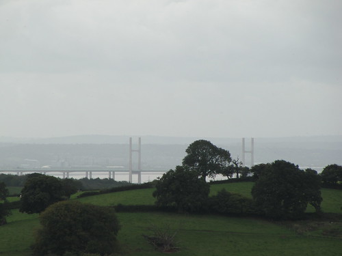
The children of Shirenewton and neighbouring Mynydd-bach were squealing fit to burst in their schoolyard as we set out into the tight, tumbled countryside of green hillsides and wooded valleys. Looking back from the heights of Itton Common, we found the prospect had broadened to lay the Severn Estuary open to view – the stork-like white gateway piers of the Old Bridge, a leaden gleam from the river, and the long line of the north Somerset hills beyond.
It was one of those steamy days when the rain threatens, but never definitely arrives. We could see a faint gauze of rain rippling up the estuary, obscuring the English shore. The faintest of sprinkles came to us on the wind, along with the barking of a couple of collie dogs and the fruitless commands of their distant owner. They circled us, fulfilling the genetic imperative of sheepdogs as they tried to herd us where we didn’t want to go. ‘Ah, leave ‘em – stupid sheep – up on their hind legs, eh? – what’ll they think of next?’ yapped the collies to each other as their master hauled them away with an apologetic grin.
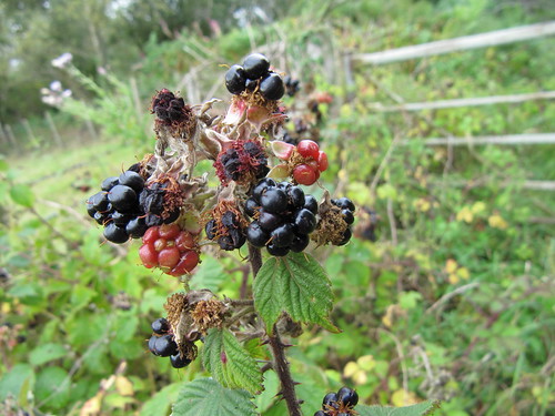
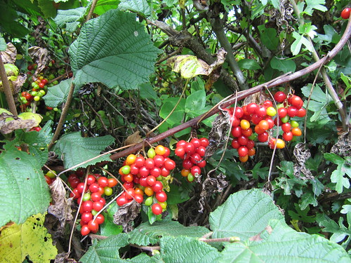
Between the plough rows of the fields, little round buttons of fungi punched up pale caps crazed across with dark zigzag cracks. Down in the lanes near Coetgae Wood the hedges were thick with fruit – elderberries in dangling clusters turning from green to black, scarlet hips and crimson haws, blackberries green, red and indigo on the one stalk, and necklaces of deep orange bryony berries as plump and tempting as a witch’s redcurrants. The open-handedness of nature, so casually stringing the countryside with wonderful colours, shapes, and means of sustenance for winter-bound creatures, struck home for the ten thousandth time.
There must be a fabulous gardener at Little Pant-y-cosyn on the way back to Shirenewton. The cottage flowerbeds were still bright with late-flowering geraniums. From the turn of the drive we looked back at the parent farmhouse of Pant-y-cosyn, three-storeyed and many-windowed, a house built for farm servants and big families back when Welsh Border farms were self-contained communities. A few steps more and we were staring down across the twin bridges of the Severn, over into rainy England, another country.
Start & finish: Tredegar Arms, Shirenewton, Monmouthshire NP16 6RQ (OS ref ST 479936)
Getting there: Bus – Service 63 (Chepstow-Cwmbran) to Shirenewton Road Junction
Road – M4; M48 Jct 2; A466 (‘Chepstow’); in 1 ¾ miles, left (B4235) to Shirenewton
WALK (6 ½ miles, moderate, OS Explorer OL14):
Leaving Tredegar Arms, right (‘Chepstow’). Pass Tan House PH and bear left downhill. In 150 m on right bend, fork left over stone stile (482938; fingerpost); cross field, aiming between houses. Over stile (yellow arrow/YA); on to cross lane (484941); left down green path (‘Chepstow Road’). Cross B4235 by Carpenter’s Arms PH (485942); on down track opposite. At bottom it curves left, but keep ahead down grass path, through gate, over stream and uphill, keeping right of Roughet’s Wood. Through gate at corner of wood (486947), through next gate and the following one, keeping trees on left. Beyond next gate, right (483952) along hedge; left at field corner to barn (485954). Diagonally left over next field to cross stile (484957, YA). Down right side of wood to cross road (481958). Footpath down 2 fields to cross stile to crossroads (479960) at Rhyd-y-fedw Green.
Go over, up lane past Pyotts Cottage and on for ½ mile past Coetgae Wood. 250 m past wood, left (471964; fingerpost) down Coed-llifos Farm drive. In 100 m, right along plantation edge. In 100 m pass barn on right (469965). Don’t go left or right here, but aim ahead down rubbly slope to tarmac lane with barns on left. Follow lane to right. Keep right of house, through gate; down field slope, through gate (467963); down next field, into wood. Across footbridge (466961), up path, over gate (wired up); up field slope to far right corner; left down grassy lane, through Pant-y-cosyn farmhouse gate (465959). Ahead between house and shed; on up drive for ½ mile to cross B4235 (466952).
Up bridleway opposite (fingerpost) to T-junction (466949); left past Marls Farm to road (464946). Left for 100 m, right across mouth of side road (‘Earlswood’); over stile (fingerpost). Down field, over stile; left over stile into lane (463944). Right past Upper Argoed Farm. At crossroads (462943), hairpin left (bridleway sign). In 100 m, right over stile fingerpost). Down field slope past lone tree; through gate immediately below beside another tree (463940). Cross dirt track; keep ahead up field slope, bisecting field, to top corner (left of a gate); bear left through neck of woodland (463939). Through gate; cross field to gate on skyline (464937); right along gravelled lane (not sharp right along footpath!). In 100 m lane bends right; keep ahead here on grassy green lane for ⅓ mile, down to road (469932). Left to junction opposite golf clubhouse (474934); left to Shirenewton.
NB: A walk for those who can find their way confidently with map/compass/GPS. Detailed directions (essential!), online map, more walks: www.christophersomerville.co.uk
Lunch: Tredegar Arms, Shirenewton (01291-641274; www.thetredegararms.co.uk)
Information: Chepstow TIC (01291-623772);
Shirenewton Community Council: http://www.shirenewtoncc.org.uk
www.ramblers.org.uk www.satmap.com www.LogMyTrip.co.uk