A beautiful day of blue sky and cold wind over County Down. ‘OK, what we’ll do,’ offered Fiona Mullan of Mountain Sojourns, ‘is head up Doan.
First published in: The Times Click here to view a map for this walk in a new window


Facebook Link:
That’s a good wee scramble, and it’s right in the heart of the Mournes so there’s brilliant views of all the main peaks.’
The Mournes are manageable mountains; they extend an invitation rather than a threat. We were lucky to have Fiona as a companion. She’s been in outdoor activities all her life, she’s cheerful and funny, and she knows these famous but under-walked mountains as well as anyone.
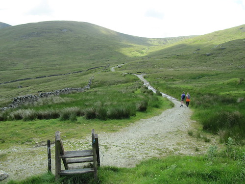
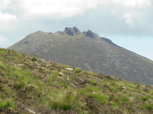
The stone-rubbled path led gently up a slope of short grass spattered with heath bedstraw, heading for the Mourne Wall, a 22-mile long monument to the hungry men of the 1900s. They built it across the main summit to demarcate the Mourne catchment area, and it stands as a guide for anyone roaming here. At the Wall stile we stopped to stare over the crescent of Lough Shannagh lying low, the long back of Slieve Binnian looming over Silent Valley Reservoir, the ragged granite castle of Bearnagh’s summit, and mighty Donard in the east with a pimple of cairn on top, looking out on a broad sweep of sea. In the foreground rose the horse’s neck and craggy head of Doan, our aiming point.
Down into the hollow of the hills, a slog among eroded peat hags and a climb up the nape of Doan. A scramble by boot and finger tip up a rough granite outcrop and we were sitting pretty with our sandwiches at the peak, absorbed in a great cartwheel panorama of mountains, lakes, sea and sky.
Back at the Mourne Wall once more and looking down on Lough Shannagh, we made out a slip of sandy beach and a pair of tiny figures swimming out from shore. ‘Hmm,’ said Jane, ‘I envy them. What a gorgeous place to cool off!’
Back beyond the Wall we struck up the broad green flank of Ott Mountain, walking the grass with a soft swish of boots. A trackless uphill pull under lark song up to the summit cairn, a heap of chunks of striped and contorted shale and quartz. A quick glance back to the rugged head of Doan, and we were bowling downhill on the homeward stretch.
;)
Start & finish: Ott/Blue Quarry car park, Mourne Mountains (OSNI ref J280278).
Getting there: Bus – Mourne Rambler (http://www.mourne-mountains.com/mournes/information/), May-August
Road: A2 to Newcastle; A50 towards Castlewellan; left on B180 (‘Bryansford, Hilltown’). In 3 miles (5 km), left (‘Kilkeel, Silent Valley, The Rock’). In 3½ miles (5.5 km) park in Ott/Blue Quarry car park on right
Walk (5 miles, moderate/hard grade. OS of Ireland 1:50,000 Discovery Sheet 29; 1:25,000 Activity Map ‘The Mournes’): Cross road, over stile, follow stony path. In 200 m fork right, uphill to Mourne Wall in saddle on skyline (OS ref 290265). Stile across wall; left of 2 paths, aiming for Doan ahead. In ½ mile pass white stone heap; fork right into dip; up spine of Doan. At top, pass left of first craggy outcrop; bear right up to second outcrop. Keep to left side of it; scramble to top (302262). Return to Mourne Wall stile; recross; aim half left up rough ground to Ott Mountain summit cairn (284270); descend to car park.
Lunch: Picnic; or Meelmore Lodge, signposted off B180 (028-4372-5949; www.meelmorelodge.com)
More info: Newcastle Tourist Office (028-4372-2222); www.mournelive.com
www.discovernorthernireland.com
Subscriber Walks: Enjoy a country walk with our experts. Mourne Mountains, Co. Down, N. Ireland, 8 July. Email timespluspartners@newsint.co.uk to book. Tickets £10.
www.ramblers.org.uk www.satmap.com www.LogMyTrip.co.uk