They dress their wells in the Peak District – always have, probably always will. First published in: The Times Click here to view a map for this walk in a new window

Facebook Link:
The old springs and sources of Derbyshire are famous for the intricate way they are ornamented by the local people with pictures of flowers and seeds in high summer. But here in Middle Mayfield across the county boundary in Staffordshire, they’re proud to carry on this ancient pagan tradition, too, garlanding the village wells in June come rain, come shine.
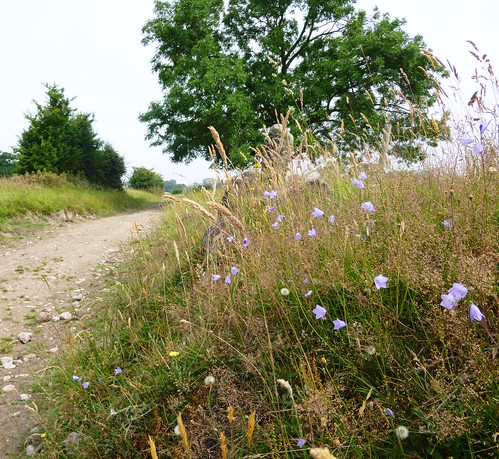
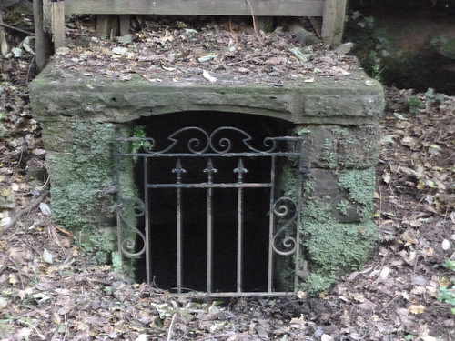
On a close, steamy morning, with heatwaves and thunderstorms threatened, we passed three or four wells on our way up Hollow Lane out of the village, the dark still water concealed like a treasure behind gridded gates or wooden doors. Spatters of blue and white seeds and stones showed where they had been glorified only a month before. Now the dimpling sources lay in secret among the borage and comfrey, knapweed and moon daisies along Hollow Lane.
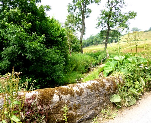
From the ridge at Ashfield Farm we had a view lent mystery by the thick grey heat – the misty woods and hayfields of the River Dove’s deep valley behind us, and the long bald head of Blake Low rising ahead. Then we plunged down through Gold’s Wood to walk the bank of the shallow, glass-brown Ordley Brook. The local geology seemed to be having an identity crisis – the houses were of beautiful sun-paled pink sandstone, but the abundant scabious where the butterflies were feeding spoke of lime beneath the soil. The knobbly old shaft of the medieval Ousley Cross beside the road was peppered with conglomerate pebbles – another puzzle.
A stony lane between fields of skittish cattle brought us up to Stanton, from where Flather Lane rose northwards under shady ash and hazels to leave us on the brink of Cuckoohill Wood and its steep little gorge. Here Ellis Hill Brook chuckled under giant hogweed and the sky-blue flowers of nettle-leaved bellflower.
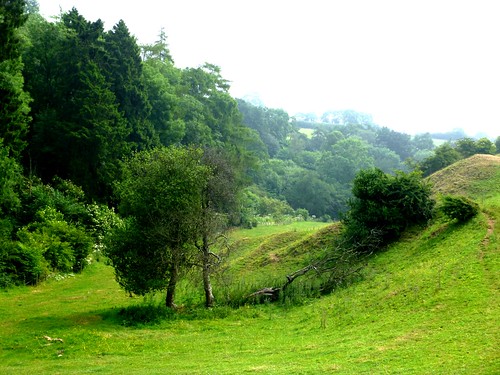
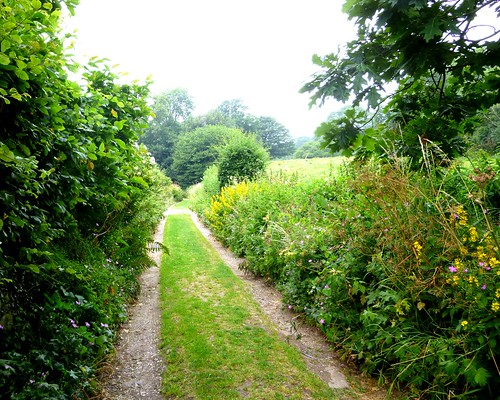
After skirting Leasow and Ellishill Farm we dropped into the cleft and went south beside the brook through thickets of nettles and brambles. A stiff climb to the ridge once more, and we followed the ill-waymarked but lovely Limestone Way path across newly mown hayfields on the crest of the land, with a wonderful breeze to cool our sun-baked faces.
Start: Rose & Crown PH, Middle Mayfield, Staffs DE6 2JT (OS ref SK 148447)
Getting there: Bus 409 (arrivabus.co.uk) Ashbourne-Uttoxeter
Road – Middle Mayfield is on B5032 (off A52, 2 miles west of Ashbourne)
Walk (7½ miles, moderate, OS Explorer 259): Opposite Rose & Crown, up Hall Lane. Just past Old Hall, left up Hollow Lane (147449, fingerpost). In 500 m leave trees by stile (142448); ahead with hedge on left. Cross stile; bear half right, aiming right of Ashfield Farm, to cross stile (139448, 2 yellow arrows/YA). In 30 m, right through squeeze stile/SS (YA). Diagonally left, over stile beside right-hand of 2 gates. Follow right-hand hedge to cross concrete roadway (137447); in 50 m, right through gateway (no waymark); half left to cross SS. Follow hedge on your left. Through next SS; on past conifer plantation. At end, over wooden stile (133447); right to bottom of slope, left along wood edge. In 250 m, right through stile (132447, YA); down path through wood, curving right in 150 m to descend and cross Ordley Brook by footbridge (131448). Left along far bank for 700 m to road (126445). Ahead for 50 m to see remains of Ousley Cross on right.
Retrace path along Ordley Brook. In 200 m cross side stream; in another 50 m, left (128447) through stile gap (YA, ‘Weaver Walk’/WW). Follow path through wood to stile out of trees (128448, WW). Forward to stone wall; left along it (YA, WW). Soon path becomes grassy lane. In a little over ½ mile, at a gate by Smithy Moor Farm (131457), don’t turn right (YA), but go through gate ahead (fingerpost) and on up farm track for ¼ mile to road on outskirts of Stanton (130460). Left; in 150 m, right up Flather Lane.
In ½ mile, after passing silage clamp on right, continue along wide grassy lane. Descend to cross stile (131472, YA); then steeply down to Cuckoohill Wood. Cross stony gap in bottom left corner of field (131473); bear left along stream bank for 50 m; cross footbridge and up steps to cross stile into field. Bear left and follow line of electricity poles across field to cross stile/kissing gate into field just south of Leasow (132477). Right along fence for 100 m; right over triple stile (YA); half left to cross double stile (133477). Half left to go through SS by holed stone. Aim for Ellishill Farm across field, and through SS.
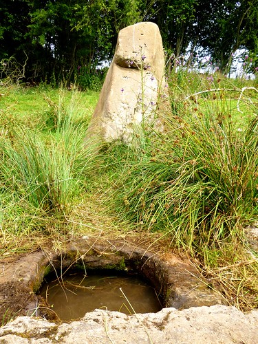
NB Path is currently being diverted to pass left of house – please watch for signs! At time of writing, path passes close to right of house (134474) and continues for 50 m to go through wall gap (135473). Ahead along ridge with hedge on left and valley on right. In 100 m (135472), diagonally right down slope to bottom edge of field. 100 m from end of field, right over stile into wood (135469, YA). Follow path (can be very overgrown!) south for ½ mile on left (east) bank of brook. Just beyond stile out of wood, pass well and standing stone (137464) to Stanton Lane (138462).
Left up lane, past Harlow Farm drive. In another 150 m, at top of hill, right through gate (142464, arrow) on Limestone Way (labelled as such on map). Through SS above farm and on; at next gate, through stile on left of it (143461). On with hedge on right, through gateway (YA); half left across field to stile (144459, YA); on with hedge on left to double stile (YA). Across field to SS (YA); halfway across next field, right through hedge (143455, stile, YA) and left along green lane. Cross stile by metal gate; same at next one. In another 70 m, left (142452, YA, WW on your right) up hedge, over ridge and down through stile in left corner of field (143451, YA). Descend with hedge on left for ¼ mile to lane by Old Hall (148449). Right into Middle Mayfield.
Lunch/Accommodation: Rose & Crown, Middle Mayfield (01335-342498; roseandcrownmayfield.com). NB Closed Sunday evening, all Monday; but B&B operates 7 days.
Middle Mayfield Well Dressing 2014: Sat 14 June, 11 a.m.
Info: Ashbourne TIC (01335-343666); visitpeakdistrict.com
David Odling has kindly sent these notes (22.10.17). Thanks, David! …
1. At the northern end of the walk near Leasow, you wrote “Right …
100m; right over triple stile (YA); half left to cross double stile
(133477). Half left to go through SS by holed stone.” This needs
correcting: the double stile is actually another triple
(wood-stone-wood, like the previous one); more importantly, it should
then read “Half right to go through SS …”, not “Half left …”.
2. The diversion to the left at Ellishill Farm is complete with new
YAs supplemented by “Diverted Footpath” discs.
3. However, the new route rejoins the old at a most unfriendly stile –
you need v. long legs, especially on the downward side; the path then
descends steeply and awkwardly through scrub and trees (narrow and
slippery), although there is a parallel, concrete farm track which you
are kept off.
4. The subsequent path along the left bank of the brook is, as you
state, overgrown/far from clear especially over the first 1/4 mile.
5. This whole stretch of about 1/3 – 1/2 mile from the unfriendly
stile was tough going and, yes, it is December. As an experienced
walker with good, strong boots, I did not mind, but I did wonder about
the description of the walk as “moderate” – fine for the rest of it,
but for this stretch??? Perhaps a advisory note about wet/winter
weather.