First published in: The Times Click here to view a map for this walk in a new window


Facebook Link:

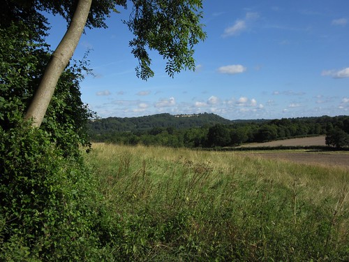
A sunny morning, windy along the south coast, still and warm here in the Hawkley valley under the great hangers of East Hampshire. Those hangers – steep-sided slopes of chalk and greensand covered in thick woodland – have enchanted poets and artists, writers and walkers since people first began to look on the landscape as something wonderful and uplifting, rather than as an adversary to be wrestled with and overcome.
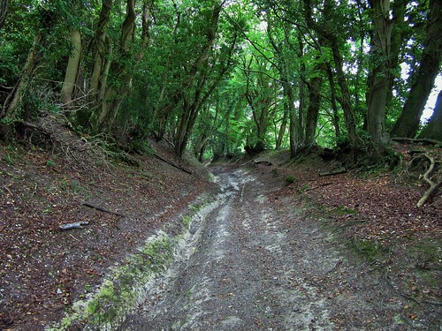
The sun cast long black shadows from the woods clinging to the scarp of Hawkley Hanger. Raspberries and blackberries hung in the margins of the field paths we walked, along with ropes of heart-shaped bryony leaves, and umbellifer heads full of seed ready to be scattered at the brush of a hare’s flanks or a walker’s trouser leg. Hollow old Standfast Lane snaked deeply sunk in the greensand, overhung with coppiced hazel sprays and floored with flinty cobbles of malmstone. Hazelnuts had already fallen and lay scattered along the laneways and the road through Empshott Green where we picked up the long-distance Hangers Way.
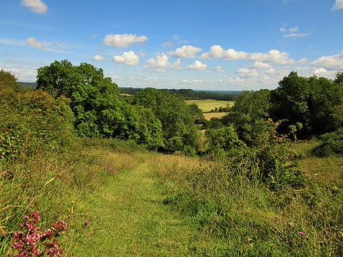
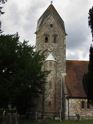
The Way wound southward through the skirts of Hawkley Hanger. We walked in and out of shadows and sunsplashes, the deep pink shade of a grove of old yews, a translucent green window of beech leaves giving a glimpse of the tower of Hawkley church with its cap like a jousting helmet rising from trees. We turned through the outskirts of the village into a tangle of greenery around the multiple threads of the Oakshott Stream, then a stony lane that climbed steeply up from Middle Oakshott. A cherry plum tree overhung the path; we scooped up a few of the plump wine-coloured windfalls and sucked the sweet flesh from the bitter skins as we went on steadily up to the crest of the hanger at the Shoulder of Mutton.
Edward Thomas, early 20th-century poet and mighty walker, lived in Steep village at the foot of the Shoulder of Mutton. These were the views he loved – south over Steep to the rising country beyond, north to Hawkley’s church and houses in a slanting patchwork of corn and pasture, woods and hanger slopes. We stared our fill, then went slipping and sliding down an ancient flinty holloway on the homeward stretch to Hawkley.
Start: Hawkley Inn, near Petersfield, Hants GU33 6NE (OS ref SU 747291)
Getting there:
A3 (Petersfield-Haslemere); B3006 to Liss; Hawkley is signed from Spread Eagle PH in West Liss.
Walk (8½ miles, moderate, OS Explorer 133): Leaving Hawkley Inn, left (east) up road. Across T-junction (749291) on fenced footpath (yellow arrow/YA). Left at lane (752294) past Uplands Farm; at next left bend, right (750295, Bridleway fingerpost, anticlockwise round field edge. In far right corner (751299, fingerpost) right down lane. At Mabbotts house (752300), take middle of 3 tracks (‘Byway’). In 600m, leave trees and follow field edge; in 100m, left (755305, kissing gate), and fork right on path along bottom edge of wood. In 450m, just after crossing stile and before reaching a house (750306), YA on telegraph pole points right over stile, across footbridge and up to Mill Lane (750307).
Right; in 100m, left up sunken wooded lane to road at Quarry House (746310). Left; in 300m on right bend, left over stile (743310; ‘Hangers Way’/HW). Follow HW across fields; at lane, left (740308); past Vann House and pond, right (stile, HW) up hedge. Anti-clockwise round 2nd field; on south (738302, HW) in tunnel of trees. In 1 mile, left out of trees (741290, HW) along field edge into Hawkley.
Left at road (745290); fork right at village green; right again along Cheesecombe Farm Lane (HW). In 200m, fork right up ramp (746288, HW, ‘Steep’). Fork left by gate (HW). In 200m, cross stile (747286); bear right (HW fingerpost by fence on left, 30m down) round slope of field, keeping lower edge of wood on right. In 200m, right across stile (746285); follow path round to left (HW) and on. Cross Oakshott Stream by footbridges (742283, HW). At Middle Oakshott cross road (741279, HW) and on up stony lane. In 150m, left over stile by house (740277, HW); follow path, steeply up through Access Land (740275); over stile, through wood and on up to wood at crest (739271).
Right along Old Litten Lane (HW); in 150m, left (738270, ‘Shoulder of Mutton’) to bench and viewpoint. Return to Ashford Hangers NNR notice; right along woodland path. In 150m, just before wooden barrier, fork left (740270) and follow red horseshoe waymarks up to Old Litten Lane (742272) Left for 100m; just beyond ‘car and motorcycle’ sign, right (741272) down stony lane for ⅔ mile. At road (745278), ahead; in 100m, left along stony lane for 1 mile back to Hawkley.
Conditions: Some steep slopes; holloways can be sticky and slippery after rain.
Refreshments/Accommodation: Hawkley Inn (01730-827205; hawkleyinn.co.uk) – a lovely welcoming country pub; great beer choice!
Info: Petersfield TIC (01730-268829); visit-hampshire.co.uk
satmap.com; ramblers.org.uk;
Today I did your Hawkley, Hants walk with husband and son. It was quite lovely, and your directions were immaculate. Thank you!