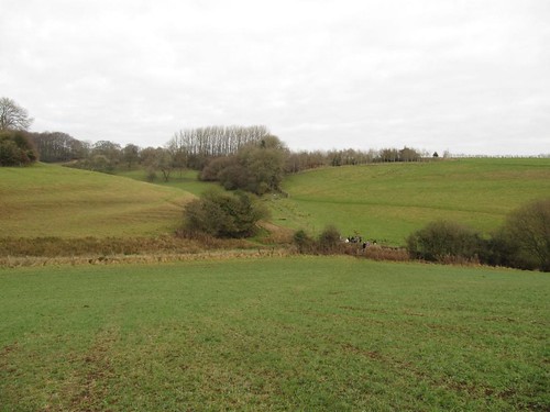
On a cold dewy morning we set off from the Hunter’s Hall Inn, a cheerfully chattering crowd of friends delighted to be up and away from post-Christmas lethargy. The wide south Cotswold fields were heavy with meltwater, their winter wheat flattened like a giant’s crewcut by weeks of lying under snow. Hereabouts the Gloucestershire landscape revolves around a network of delectable hidden valleys, snaking unseen a hundred feet below the upland fields.
First published in: The Times Click here to view a map for this walk in a new window


 Facebook Link:
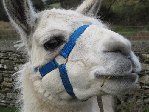
Down in Hay Bottom we met a trio of superbly disdainful llamas being led reluctantly across a footbridge. They dug in their widespread horny front toes, resisting until a coaxing word from their owner melted their intransigence. ‘People just love to go walking with them,’ said the llama leader. ‘They’ve got lovely natures – haven’t you, Two Tone?’ Two Tone fluttered a pair of eyelashes a Fifties starlet would have killed for, and nuzzled our hands with his baby-soft lips.
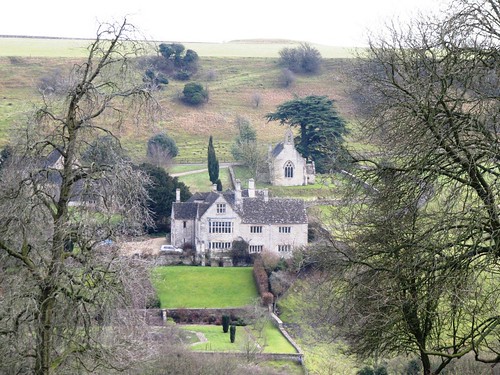
We climbed through Church Covert to reach the closed and wooden-shuttered Church of St Bartholomew, all alone and lonely on its ridge. Nearby rose a little round tuffet of rough grass surrounded by a ditch – all that remains of some Norman lord’s motte-and-bailey castle, commanding a deep cleft carved through the oolitic limestone by the Little Avon river. Diminutive settlements shelter here, gorgeous in golden stone – the close-clustered farmhouses and barns of Newington Bagpath, the battlemented Georgian mansion of Lasborough House, and between them the sloping gardens of medieval Lasborough Manor, a Jilly Cooper dream of gables and tall chimneys. We stopped at the lip of the escarpment to gaze and speculate – ‘Oh, there’s Rupert Campbell-Black eyeing up the au pair!’ – before dropping down the parkland slopes into the woods along Ozleworth Bottom.
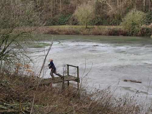
Frozen lakes where we skimmed twigs across the ice; muddy sloshes through half-melted ruts; a zee-zee-zee of long-tailed tits in the fir tops; the sense of winding deeper into secret country. A quick halt for rum-laced hot chocolate and bickies (New Year Resolutions come into force tomorrow, we decided); then a stiff climb up through the trees to reach Scrubbett’s Lane and the gambolling pigs of Scrubbett’s Farm. ‘The black ones are Hampshires,’ explained the farmer when we met her in the lane, ‘and those gingery ones are Durocs from New England. They love dashing about all over the place –must be happy, I suppose!’
Back at the Hunter’s Hall we stripped off scarves and gloves, ditched the muddy boots and sat down to lunch nearly 20 strong. A cheery warm pub, a lowering afternoon outside and a good post-walk glow – ye canna whack that, man.
Start & finish: Hunter’s Hall Inn, Kingscote, near Tetbury GL8 8XZ (OS ref ST 814960)
Getting there: Hunter’s Hall is on A4135 Dursley-Tetbury road (M4 Jct 18/17, M5 Jct 14/13)
Walk (5½ miles, easy/moderate, OS Explorer 168): Leaving Hunter’s Hall front door, right along A4135; cross mouth of side road; right into field; follow left-hand of 2 fingerposts across field. On far side, through hedge (814956; yellow arrow/YA); in 50 m, where fence bears left, continue downhill (YA) with wall on right. At end of wall, bear half left across slope to go through gate (813953; ‘public right of way’); up woodland track to road; left past St Bartholomew’s Church (815948). Immediately right (fingerpost); pass motte (816947); bear left along track by wall. In 200 m, though gate; bear left up to continue along edge of escarpment. In ¼ mile, descend; cross Lasborough House drive (819938); through gate; follow grass track below house, on into wood in valley bottom (816935). Follow valley-bottom path for 1¼ miles, passing ponds (815934) and a flat area with a pond at far end (809930). Continue, soon passing through a gate along Ozleworth Bottom. At next gate/stile, where path slopes downward (798929), don’t go through gate, but bear sharp right up slope to go through gate with waymark (799931). Steeply up woodland path. In 300 m, meet gravelled track on bend; bear right uphill along track for ½ mile to Scrubbett’s Lane (808936). Left to pass Scrubbett’s Farm, then pass left turn to Bagpath (807946). In 200 m, right over stile (807949; fingerpost); cross field (YAs) and road (810952). Descend to cross footbridge (812954); up through gate; follow track to Hunter’s Hall.
NB – Online maps, more walks: www.christophersomerville.co.uk
Lunch: Hunter’s Hall Inn (860393; www.huntershallinn.co.uk) – very friendly staff, good walker’s grub
Cotswold Camelids (walks, picnics with llamas) – 07910-294802; www.cotswoldcamelids.com
More info: Tetbury TIC (01666-503552); www.cotswolds.com
Re: Lasborough walk – Thanks for the mention and for putting our details in your article. Glad you all enjoyed your walk. I know the Llamas enjoyed meeting you!