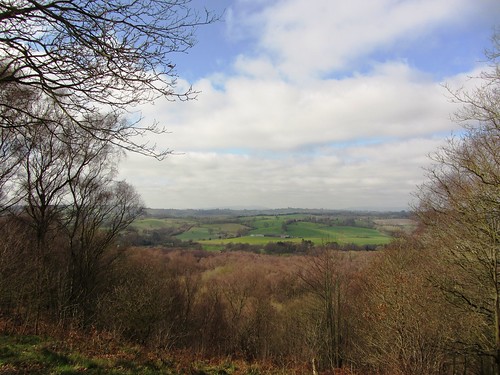
The view from the sandstone peak of Kinver Edge on this brisk, sunny morning was utterly sensational. First published in: The Times Click here to view a map for this walk in a new window

Facebook Link:
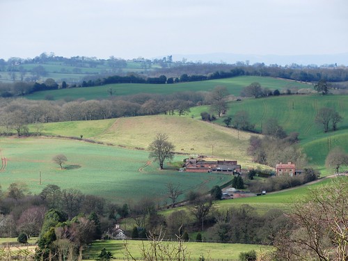
It was all there, spread at our feet like butter on a green and lumpy pancake – the Worcestershire plains stretching away south-east, the quarried prow of Titterstone Clee and the amorphous lump of Brown Clee standing up far to the west, and dead in the south the pale blue humps of the Malvern range floating on a surf of mist.
Eventually we tore ourselves away and went south along the ridge, following the broad pebbly track of the Staffordshire Way as it wound between the mossy tree trunks, with tremendous views over the precipitous drop of Kinver Edge’s west flank. A side path brought us down through conifers, and on along a green lane by the balustraded Italianate tower of Blakehall House. Two horses with beautiful feathery legs went snorting impatiently by – ‘Irish cobs,’ said their owner, ‘they don’t like to stand still!’
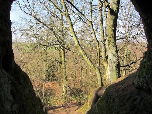
Just here, hidden in the ground somewhere under our boots, ran the 3-mile complex of Drakelow Tunnels, ghost-haunted by local reputation, the remnants of a Second World War ‘shadow factory’ built well away from the bombed-out Black Country to manufacture Rover aircraft engines. Climbing back to Kinver Edge, we fancied we could hear the hollow boom of the tunnels. A northward stretch past the well-concealed cave called Nanny’s Rock – once home to a ‘cunning woman’ who could cure your ailments and tell your fortune – and we were dropping down towards the remarkable cliff dwellings of Holy Austin Rock Houses.
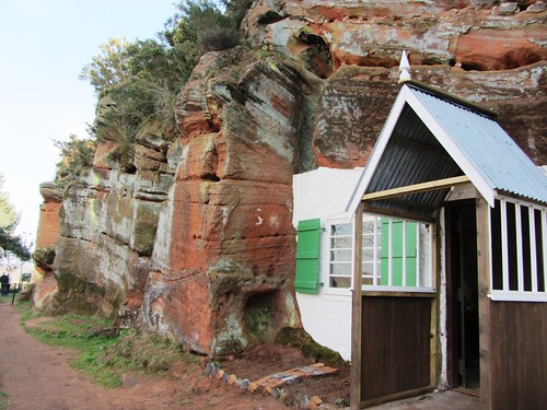
Burrowed into the rich red sandstone, their outer surfaces smoothed into house walls, windows and doors cut out, floors quarry-tiled, the Holy Austin houses have been dwellings since time out of mind, certainly since pre-Reformation days when resident Augustinian hermits gave them their name. At the turn of the 20th century Rose and Harry Shaw raised 10 children here – mostly boys, so boisterous that Mrs Shaw would banish them outside during the day. J.R.R. Tolkien knew the place, and it may have prompted him to imagine the tunnel homes of Hobbiton. The children playing Bilbo Baggins and Smaug the dragon around the rock houses this afternoon certainly seemed to think so.
Start & finish: National Trust car park on Compton Road, just west of Kinver, DY7 6DL approx (OS ref SO 836836)
Getting there: Bus 228 (networkwestmidlands.com) Stourbridge-Kinver. Road: Kinver is off A458, 3 miles west of Stourbridge.
Walk (4½ miles, moderate, OS Explorer 219): From NT car park, cross clearing with oak tree. Uphill to right – not path with red arrow, but with post labelled ‘Car Park’. At top of slope (834835), left (‘Viewpoint’ fingerpost, ‘Staffordshire Way’/SW) up path and steps to viewpoint (836834). Right (south) along SW (red and orange waymarks). In ¾ mile, go through barrier (829822). By seat, North Worcs Path/NWP continue ahead (fingerpost); but bear left downhill here (angled yellow arrow/YA). In 150m, right (831822, YA) on track through conifers. In 300m, 5 paths meet (831820) – there’s a seat on your right and a post pointing left to a path marked ‘Woodpecker, Nuthatch Trails’. Take path immediately to right of this one – i.e. straight ahead. In 200m, through barrier (831818; ‘No cycling, no horses’); in 250m, ahead (‘Cookley 1) to road in Blakeshall (831813).
Turn right; in 30m, right along green lane with houses on left, to road (829812). Right; in 50m, fork right on sandy track past lodge of Blakeshall House. On along sandy track. In 500m, right through barrier (825812; NWP), along path through conifers. In 500m, in a dip, right through barrier (825817; NWP). At top of slope. left through barrier (828817; YA, NWP, ‘Coal Tit Trail’). In 200m, at grassy reservoir (828819), right; in 30m, left (YAs, NWP). In 300m NWP meets SW at fingerpost (829822). Left here down slope; in 50m bear right (north) keeping parallel with SW above and passing Nanny’s Rock cave (830826). In another ⅓ mile (832831), ahead over crossing of tracks (not left downhill, or right up steps), up slope ahead, over brow and down to path crossing. Fork left (orange waymark). In 400m fork right (‘Rock Houses’/RH post); follow RH to car park. Rock Houses (836836) are just beyond.
NB Excellent directions of a very similar walk at walkingbritain.co.uk
Lunch: Bell & Cross PH, Holy Cross, Clent DY9 9QL (01562-730319; bellandcrossclent.co.uk)
Holy Austin Rock Houses Tea Rooms: 11-4, Thurs-Sun
Holy Austin Rock Houses: 2-4 Thurs, Fri; 11-4 Sat, Sun
More info: nationaltrust.org.uk/kinver-edge; enjoystaffordshire.com
www.ramblers.org.uk www.satmap.com www.LogMyTrip.co.uk
Click on Facebook “Like” link to share this walk with Facebook friends.
Dear Christopher,
I read your lovely piece about Kinver Edge in the Times last week and just wanted to drop you a line about our Bed & breakfast which is located on the lower slopes of Kinver edge.
We have two very well appointed ensuite guest rooms and should you or your colleagues visit the area again you might consider visiting us. Our web site is to be found at http://www.kinverbedandbreakfast.co.uk.
Kid regards,
John Hawkins